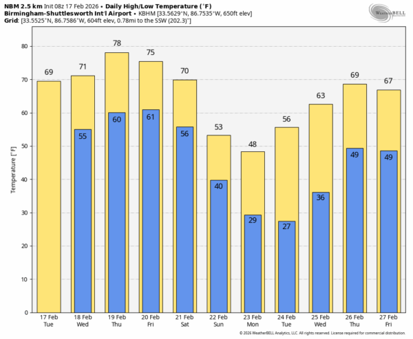
ANOTHER NICE DAY AHEAD: With a good supply of sunshine, we expect temperatures to reach the 70s across almost all of Alabama this afternoon. Temperatures will stay well above average for the rest of the week; some South Alabama communities could reach the 80 degree mark Thursday afternoon.
After today moisture levels will rise, and we could see a few small, isolated showers tomorrow and Thursday.
FRIDAY AND THE WEEKEND: A cold front will drift down toward the Alabama/Tennessee state line and become stationary. Showers and storms are likely Friday and Friday night, mainly over the northern half of the state. The air will be somewhat unstable, so a strong storm is possible, but it really isn’t a classic severe weather setup.
Showers and a few thunderstorms are likely statewide Saturday as the front begins moving southward; by afternoon the reliable European global model suggests the best chance of rain will be over the southern counties of the state. Afternoon highs remain in the 70s Friday and Saturday.
Colder, drier air arrives Sunday. Highs drop into the 50s for the northern 2/3 of the state, and by daybreak Monday a freeze is likely for north and central parts of the state.
NEXT WEEK: Températures won’t get of the 40s across North Alabama Monday, and a freeze is likely Tuesday morning down into the southern counties. But this cold snap won’t last long; afternoon highs will be in the upper 60s and 70s again by Thursday. Global models suggest showers and storms will likely return by Thursday and Friday… See the video briefing for maps, graphics, and more details.
ON THIS DATE IN 2008: A total of 13 tornadoes moved through Central and East Alabama. One was an EF-3 that tore through parts of Prattville and Millbrook injuring at least 50 people. The tornado touched down near the waste water treatment facility southwest of Prattville. The tornado tracked northeastward and crossed US Highway 82, US Highway 31, and Cobbs Ford Road. The southern and eastern parts of Prattville sustained significant damage. The highest winds likely occurred along Cobbs Ford Road/East Main Street near McQueen Smith Road and in the Silver Hills Subdivision. An estimated 200 residential homes and 40 businesses were damaged or destroyed.
Look for the next video briefing here by 3:00 this afternoon… enjoy the day!