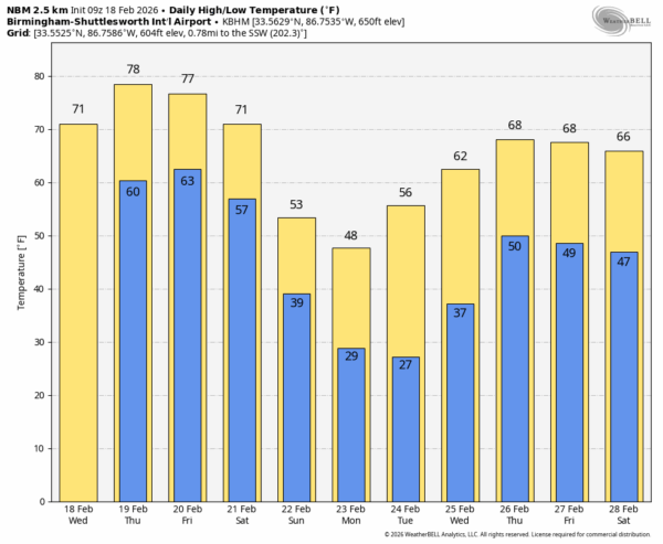
SPRING-LIKE DAYS: Temperatures will remain above average across Alabama through Saturday, with highs mostly in the 70s. A few South Alabama communities could touch the 80 degree mark tomorrow.
Moisture levels will slowly rise, and we will mention the chance of a few isolated showers today and tomorrow. Chance of any one spot seeing rain is only 15-25 percent both days.
FRIDAY AND THE WEEKEND: A cold front will drift down into Alabama Friday and we will see an increase in the number of showers and thunderstorms. The front will stall, move northward Friday night, and then it heads southward again Saturday. This will mean periods of rain and some thunder; the air will be somewhat unstable, but dynamic support really doesn’t look supportive of severe thunderstorms at this point. Rain amounts will be 1/2 to 1 inch for the northern half of the state, amounts will be under 1/2 inch for the southern counties.
Sunday will be mostly sunny, breezy, and colder with highs generally in the 50s.
NEXT WEEK: Temperatures will drop below the freezing mark both Monday and Tuesday morning over the northern 2/3 of the state… many places will see lows in the 25-30 degree range. Then, expect a warming trend over the latter half of the week with highs in the upper 60s and low 70s by Thursday and Friday. Rain and a few thunderstorms will return to the Deep South Thursday and Friday… See the video briefing for maps, graphics, and more details.
ON THIS DATE IN 1992: A thunderstorm spawned a powerful F4 tornado in southern Van Wert County in Ohio. The tornado touched down just west of US Route 127 and traveled northeastward for about 3 miles. One house was completely leveled, and nine others experienced severe damage. Six people were injured.
Look for the next video briefing here by 3:00 this afternoon… enjoy the day!