RADAR CHECK: Several bands of showers are passing through Alabama early this morning ahead of a surface front. The front will stall over Central Alabama later today, then it moves northward this evening as a warm front. The best chance of showers during the midday hours will be over the southern counties of the state, then shifting back into North Alabama late this afternoon and tonight as the front moves to the north.
It will be another very mild February day for most of the state with temperatures in the 70s.
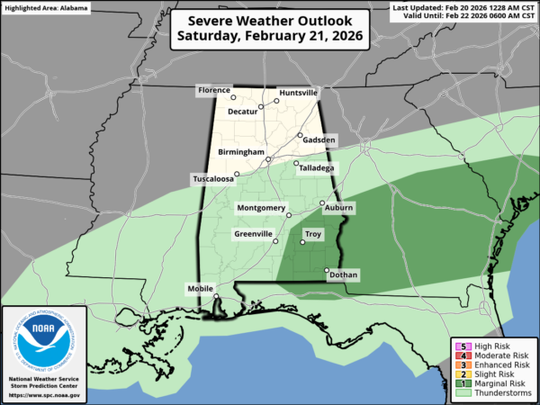
THE ALABAMA WEEKEND: The front gets a good southward push tomorrow. Showers over North Alabama early in the day will shift quickly into the southern part of the state. A thunderstorm is possible tomorrow afternoon across Southeast Alabama, where SPC has defined a low end “marginal risk” (level 1/5) of severe thunderstorms, but with weak wind fields the severe risk is very low.
There will be a large temperature spread across Alabama due to the front; during the afternoon the range will be from the low 50s over the Tennessee Valley to the upper 70s over the far southern part of the state.
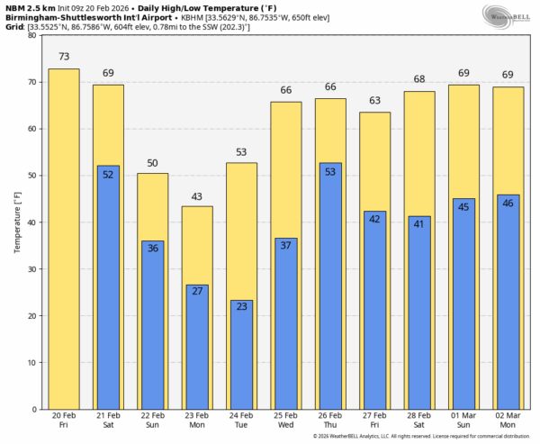
Sunday will be breezy and much colder with a sunny sky. Highs will be in the 48-58 degree range.
NEXT WEEK: A freeze is likely for much of Alabama both Monday and Tuesday morning with lows generally in the 20s. Some of the colder pockets over North Alabama could reach the upper teens early Tuesday. The weather will be warmer over the latter half of the week with highs back in the 60s and low 70s. A surface front will bring rain to the state Thursday; it doesn’t look like a severe weather setup, and there is no cold air behind this front. See the video briefing for maps, graphics, and more details.
ON THIS DATE IN 1912: A strong area of low pressure produced snow in Amarillo and high winds to Austin, Texas. In the warm sector of the low, severe storms developed and produced an estimated F3 tornado in Shreveport, Louisiana. The tornado killed nine people and injured 50 others.
ON THIS DATE IN 1989: A storm system brought 17 tornadoes to the Deep South on February 20 and 21. Four F2 tornadoes touched down in northeastern Mississippi and northwestern Alabama. One caused significant damage near Sulligent.
Look for the next video briefing here by 3:00 this afternoon… enjoy the day!