


WARM MARCH DAY AHEAD: Most Alabama communities will rise into the 80-85 degree range this afternoon with a mix of sun and clouds. A few small, isolated showers are possible this afternoon, but the chance of any one spot seeing rain is only 15-20 percent.
MORE STORMS: Tomorrow will be warm and breezy, and a few thunderstorms could form over the Tennessee Valley by late afternoon. But the main round of storms will tomorrow night; SPC has defined a level 2/5 risk of severe thunderstorms west of a line from Thomasville to Birmingham to Scottsboro; there is level 1/5 “marginal risk” as far south as Andalusia, Troy, and Lanett.

The main window for severe storms will come from about 5:00 tomorrow afternoon through 12 midnight; storms should weaken as they move into South Alabama during the pre-dawn hours Thursday. The main threat will come from strong, potentially damaging winds, but an isolated tornado or two is possible in the level 2/5 risk area.
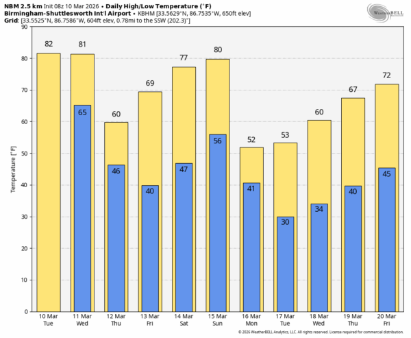
COOLER: The weather will be breezy and sharply cooler Thursday with a clearing sky. Highs will range from the upper 50s across the Tennessee Valley to the upper 60s near the coast. Some scattered light frost is possible early Friday morning across North Alabama where temperatures will dip into the 34-39 degree range. Friday will be a sunny day with a high between 67 and 75 degrees.
THE WEEKEND: Saturday will be a delightful spring day. After a cool morning, the high will be in the upper 70s and low 80s with sunshine in full supply. Look for a mix of sun and clouds Sunday with only a small risk of an afternoon shower. A cold front will bring some rain into the state after midnight Sunday night into early Monday morning.
LATE SEASON FREEZE POTENTIAL: Much colder air will follow the front for the first half of next week; models are now suggesting we will have potential for late season freeze over the northern half of the state by Tuesday morning (and possibly Wednesday morning as well). Then we expect a warming trend with highs back in the 70s by Friday. The week is looking rain-free… See the video briefing for maps, graphics, and more details.
ON THIS DATE IN 1992: An F3 tornado moved through parts of Greene and Hale counties in West Alabama; three were killed and several others injured. The tornado touched down south of Forkland… from there it crossed the Warrior River and passed south of Greensboro.The dame day another F3 tornado tore through Lauderdale County MS south of Meridian. A total of 255 dwellings were destroyed in the Zero community; three people were killed in mobile homes.
Look for the next video briefing here by 3:00 this afternoon… enjoy the day!



