


MORE STORMS: Today will be a warm, breezy day for Alabama with afternoon temperatures exceeding 80 degrees in most places. While most of the state will be dry, a line of storms will creep into the northwest corner of the state by 3-4 p.m. ahead of a cold front. Rain and storms will shift southward through the night.
SPC has defined a level 2/5 risk of severe thunderstorms for the western 2/3 of the state, and a level 1/5 for the eastern counties.

The primary threat with the storms late this afternoon and tonight will come front strong, potentially damaging straight line winds. But, a few isolated tornadoes are possible. Some hail could be involved as well.
For the southern half of the state, the rain and storms will come after midnight. Be sure you have a reliable way of hearing warnings (a NOAA Weather Radio is the baseline), and have the Alabama Weather Network app installed on your TV, phone, and tablet. We will be live through the entire event.
Rain amounts will be in the 1-2 inch range for most places, but a few communities could see over 2 inches with some flooding potential. Storms will exit the southeast corner of the state by 8:00 tomorrow morning.
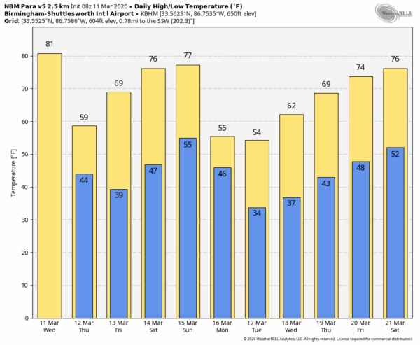
COOLER: Temperatures won’t get out of the 50s across the Tennessee Valley tomorrow with a cool north breeze. And, by Friday morning most of North Alabama will dip into the mid to upper 30s with a chance of scattered light frost. Then, with sunshine in full supply, temperatures warm into the upper 60s and 70s Friday afternoon.
THE WEEKEND: Saturday will be a beautiful day; after a low in the 40s temperatures rise into the 74-82 degree range by afternoon. Expect a partly sunny sky Sunday with a small risk of an afternoon shower over the southern counties; the high will be between 77 and 84 degrees.
NEXT WEEK: A cold front will bring rain to the state early Monday, followed by sharply colder air. The northern half of the state will have potential for a late season freeze Tuesday and Wednesday morning, followed by a warming trend Thursday and Friday. After the rain Monday morning the rest of the week looks rain-free… See the video briefing for maps, graphics, and more details.
ON THIS DATE IN 1963: An F4 tornado moved through Cullman County. The tornado moved northeast through Phelan, Berlin, and Fairview. About twenty homes and twenty farm buildings were completely demolished, and more than 120 homes were damaged across the county. Eyewitnesses described incredible destruction. One truck driver reported seeing houses and barns lifted from their foundations, trees blocking roads, and even a barn sitting on top of a truck. Two people were killed when their homes were destroyed: Geraldine Bowen, 34, near Berlin, and Minnie Dunn, 78, near Good Hope. Six others were injured.
ON THIS DATE IN 1993: I was forecasting 6-16 inches of snow for North Alabama for the following day (March 12) with strong winds and near blizzard conditions. Few people believed me, and I don’t blame them since it was mid March and the high the day before (March 10) was 75 degrees. As it turned out, the forecast was a good one. The great “Blizzard of 93” would begin in 24 hours.
Look for the next video briefing here by 3:00 this afternoon… enjoy the day!



