


BLUE SKY: Not a cloud in the Alabama sky this afternoon; temperatures are generally in the upper 60s and low 70s. Tonight will be clear with a low in the 40s for most communities. Colder spots will see mid to upper 30s.

Tomorrow will be a delightful day to start the weekend; lots of sun with a high in the 70s and low 80s.
SUNDAY/MONDAY: Moisture levels begin to rise Sunday, and a few small, isolated showers are possible by afternoon. The warming trend continues; temperatures reach the low to mid 80s over the southern half of the state.
A sharp cold front will bring a line of strong to severe thunderstorms into Alabama late Sunday night into the pre-dawn hours Monday. SPC has now defined a level 3/5 “enhanced risk” for parts of North and West Alabama, with a level 2/5 risk for the rest of the state.

Upper air wind dynamics with this surface front will be impressive, and models are trending toward higher instability values. Storms late Sunday night into the pre-dawn hours Monday will be capable of producing damaging winds, and a few tornadoes will be possible as well. Everyone will need to have a way of hearing warnings; the main window for severe storms will come from about 11 p.m. Sunday through 7:00 a.m. Monday.
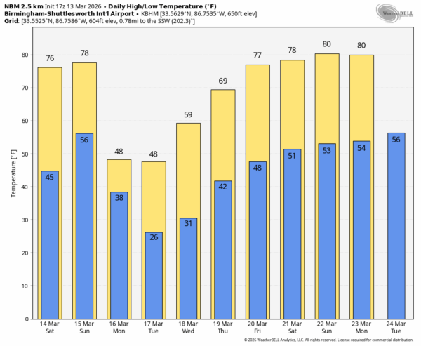
Rain ends early Monday morning, and more cold air rolls into the Deep South. Temperatures won’t get out of the 40s Monday over North Alabama, and a freeze is likely for just all of the state by Tuesday morning with most places dipping into the 20s. Another freeze is likely early Wednesday morning for the northern 2/3 of the state.
A warming trend begins Wednesday afternoon, and afternoon highs return to the 70s by Thursday and Friday. After the rain early Monday morning, the rest of the week will be dry with sunny days and clear nights. See the video briefing for maps, graphics, and more details.
ON THIS DATE IN 1954: A large F3 tornado struck Fort Mitchell, Alabama and Fort Benning, Georgia, damaging or destroying homes, buildings, and military equipment, killing two people and injuring 20 others. Another long-tracked F3 tornado began near Howard, Georgia, striking the communities Roberta, Knoxville, Lizella, Vineville and Macon, damaging or destroying over 750 homes, killing five, and injuring 75.
Look for my next video briefing here by 6:00 a.m. Monday…



