


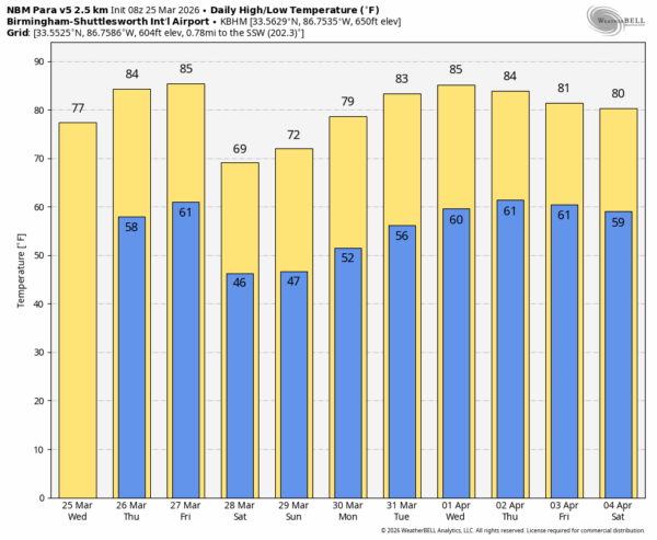
DRY PATTERN CONTINUES: Dry weather continues across Alabama through tomorrow. Expect a high today in the 74-80 degree range for most communities; tomorrow will be warmer with a high in the 80s.
Most communities will stay dry Friday, although we will mention some risk of isolated showers Friday evening across the Tennessee Valley ahead of a cold front. The weather stays warm Friday with a high in the 80s statewide.
Cooler air follows the Friday night front… the high Saturday will be in the 60s over the northern third of the state, with low to mid 70s for the rest of the state. Highs Sunday will be in the 70s; the weekend will feature sunshine in full supply both days.
NEXT WEEK: Still no sign of meaningful rain through the week as the unusually dry pattern continues. Afternoon highs return to the 80s Tuesday and through the rest of the week… See the video briefing for maps, graphics, and more details.
ON THIS DATE IN 2021: A significant tornado outbreak struck central Alabama as part of a larger multi-day event across the Southeast, featuring multiple violent long-track tornadoes amid a rare high-risk severe weather forecast. NWS confirmed four EF-3s, three EF-2s, and three EF-1s, with six fatalities near Ohatchee in Calhoun County from a 38-mile EF-3 tornado.
One long track EF-3 moved from near Sawyerville to just south of Columbiana; it was the longest track of the day at nearly 80 miles across five counties. It downed transmission towers, debarking trees, and destroying homes/mobile homes; injuries occurred but no deaths.
Another long track EF-3 moved from near West Blocton to Vandiver. It moved through the southern part of the Birmingham metro area producing major damage, but there were no fatalities thanks to timely warnings.
Look for the next video briefing here by 3:00 this afternoon… enjoy the day!



