


SUMMER PREVIEW: Today will be the warmest days so far this year for much of Alabama… we expect a high in the 87-91 degree range this afternoon for most communities with a good supply of sunshine.
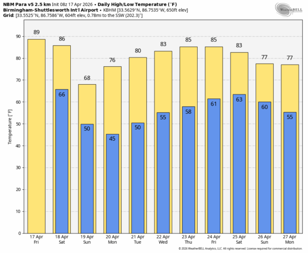
WEEKEND FRONT: A cold front will bring some significant weather changes over the weekend. Showers will begin to push into Northwest Alabama tomorrow afternoon; the rest of the state will be dry with a high in the 80s. Showers and few thunderstorms are likely over the northern half of the state tomorrow night as the front pushes southward. Severe storms are not expected with weak dynamic support and marginal instability.
Showers will fade during the day Sunday as they move into South Alabama; rain amounts there will be light and spotty. Most of the state will see a mostly sunny sky by Sunday afternoon, but the day will be much cooler with highs in the 66-74 degree range.
Rain amounts over the weekend will range from near one inch around the Shoals, to just a trace across the southeast counties.
NEXT WEEK: Monday morning will be cool with lows generally in the 40s… we might see a few spots reaching the upper 30s over the northern third of the state. Highs will be in the 70s Monday, followed by 80s for the rest of the week. The weather will be dry through at least Thursday. Global models continue to suggest rain will return at some point over the weekend (April 25-26), but consistency has not been good and it is way too early for a specific forecast. See the video briefing for maps, graphics, and more details.
FOOTBALL WEATHER: Auburn’s annual A-Day spring game is tomorrow (2:00p CT kickoff at Jordan-Hare Stadium). The sky will be partly to mostly sunny with temperatures in the 80s. No risk of rain.
The Birmingham Stallions home opener is tomorrow against the Orlando Storm (3:00p CT kickoff at Protective Stadium). Expect a partly sunny sky… a shower is possible during the second half. Temperatures will be in the mid 80s at kickoff, falling to near 80 by the final whistle.
CONCERT WEATHER: Bryant-Denny Stadium will be packed tomorrow night for the Morgan Wallen concert; be sure and have some rain gear. A few showers are possible in Tuscaloosa as early as 4:00, but the more widespread rain will come after 7:00. Some lightning is possible, but we don’t expect any threat of severe thunderstorms. Temperatures will fall from the low 80s at 6:00 into the upper 70s by 8:00.
ON THIS DATE IN 1963: A massive F4 tornado tracked for 70 miles from Essex, Illinois, into Indiana. Damage near Essex was reported as “near-F5,” where several well-constructed homes were completely swept away. One person was killed, and 70 were injured.
Look for the next video briefing here by 3:00 this afternoon… enjoy the day!



