


RADAR CHECK: We have patches of light rain across the southern half of Alabama this morning… rain will become widespread later today and tonight as a wave of low pressure forms along a stalled front over the northern Gulf. The air will be cool and stable, no thunderstorms for most of Alabama. There is some chance of thunder near the coast, but the high resolution models keep the unstable air offshore tonight. Rain amounts will be in the 1/2 to 1 inch range over the next 24 hours.
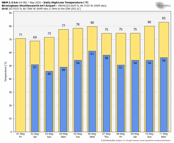
THE WEEKEND: Rain will end from the northwest early tomorrow morning, and the sky becomes sunny during the day with a high between 68 and 74 degrees. Sunday will be a sunny day… after a low in the 40s highs will be in the 70s.
NEXT WEEK: Dry weather continues through Tuesday; showers and thunderstorms will return to the state Wednesday as a cold front moves through. At this point it doesn’t look like a severe threat; Thursday and Friday will be dry and pleasant. See the video briefing for maps, graphics, and more details.
ON THIS DATE IN 1953: One of four tornadoes in Alabama that day, a violent F4 carved a 12 mile path through Clay County from near Millerville to Lineville. Seven people were killed and 12 injured as the twister destroyed 19 homes, 36 other structures, and even leveled a gas station. Some chickens were stripped of feathers by the winds. Another F4 moved through Choctaw County… it was on the ground for 10 miles and 200 yards wide. This tornado was responsible for the deaths of two people and injuries to three others in the Riderwood, Lisman, and Yantley communities. According to the NWS Birmingham, two homes were “disintegrated” at Yantley and the debris was thrown over a half mile.
Look for the next video briefing here by 3:00 this afternoon… enjoy the day!



