


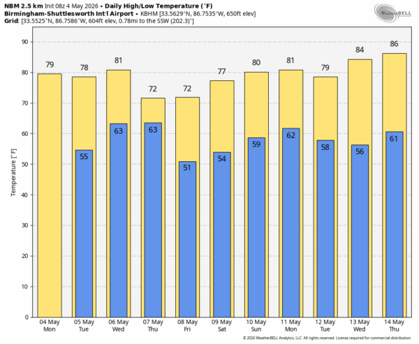
ANOTHER SUNNY DAY: Expect sunshine in full supply across Alabama today with a high in the 77-83 degree range this afternoon. The weather stays dry tomorrow with similar temperatures through the day.
RAIN RETURNS: A cold front will bring an organized band of rain and storms into Alabama late Wednesday. SPC has defined a “slight risk” (level 2/5) of severe thunderstorms over parts of North and West Alabama, with a “marginal risk” (level 1/5) down into the southern counties of the state.
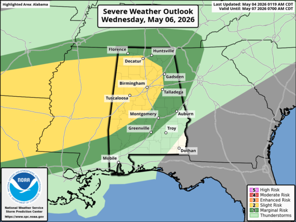
The main threat will come from strong thunderstorm winds, but hail is also possible along with a brief, isolated tornado or two. The main threat of strong to severe storms will come late Wednesday afternoon and through Wednesday night.
The front will move slowly, so rain will likely continue Thursday over the southern 2/3 of the state. Rain could even linger into Friday over the southeast corner of Alabama and along the Gulf Coast. Beneficial rain is likely, with most Alabama communities getting two inches or more.
Temperatures will reach the low 80s Wednesday ahead of the front, then afternoon highs fall into the low to mid 70s Thursday and Friday.
THE ALABAMA WEEKEND: At this point the weekend looks dry and very pleasant. Mostly sunny days, fair nights, highs between 75 and 83 degrees.
Global models suggest rain will return on Monday (May 11)… See the video briefing for maps, graphics, and more details.
ON THIS DATE IN 2007: A massive and violent tornado moved through Kiowa County in southwest Kansas, before impacting the city of Greensburg and causing very widespread devastation. The tornado tracked 28.8 miles through the area, killing 11 to 12 people and injuring 63. The tornado was the first to be rated EF5 on the Enhanced Fujita scale after the retirement of the original Fujita scale in the United States on February 1, 2007.
Look for the next video briefing here by 3:00 this afternoon… enjoy the day!



