


Tropical Moisture Keeps Alabama Wet Through Memorial Day
A broad belt of tropical moisture remains stretched across Alabama and the central Gulf Coast this weekend, keeping periods of showers and thunderstorms in the forecast each day. While widespread severe weather is not expected today, repeated rounds of rain and slow-moving storms will continue to raise concerns about localized flooding, especially where the ground is already saturated.
YESTERDAY’S WEATHER ACROSS ALABAMA
Friday brought another active round of showers and thunderstorms to portions of the state, although most storms remained below severe limits. Temperatures ranged from 73 at Cullman to 88 at Dothan and Eufaula, with Huntsville reaching 76, Birmingham 76, Montgomery 83, and Mobile 82.
The heaviest rainfall occurred across southwest Alabama, where Mobile officially recorded 5.78 inches of rain, establishing a daily rainfall record. A broad corridor across northeast Mobile County, including Creola, Satsuma, Saraland, Chickasaw, Celeste, Kushla, Semmes, and west Mobile, received more than 6 inches of rain, while isolated personal weather stations reported totals near 10.5 inches. Bayou Sara at Saraland crested at 8.98 feet, its third-highest crest on record.
SHOWERS AND STORMS RETURN TODAY
Another unsettled day is ahead statewide with scattered to numerous showers and thunderstorms developing through the late morning and afternoon. Storms will be capable of producing heavy downpours, frequent lightning, and brief gusty winds, although the organized severe weather threat is limited.
Highs will reach the upper 70s in north Alabama and the lower to middle 80s farther south. Huntsville should be near 80, Birmingham around 81, Montgomery near 82, and Dothan in the upper 80s.
WET PATTERN CONTINUES TONIGHT
Showers and thunderstorms will gradually diminish after sunset, but scattered rain will remain possible overnight. Low clouds and pockets of fog may form toward daybreak, especially where heavier rain falls today.
MEMORIAL DAY WEEKEND STORMS ON SUNDAY
Sunday will bring another round of afternoon and evening thunderstorms across much of Alabama. Most storms should remain below organized severe levels, but isolated stronger cells may produce gusty winds and very heavy rainfall.
MONDAY THROUGH WEDNESDAY REMAIN UNSETTLED
The wet pattern will continue into early next week as disturbances move across the Deep South. Numerous showers and thunderstorms are expected Monday through Wednesday, with forecasters watching the potential for a few stronger storms Monday.
Additional rainfall totals of 2 to 4 inches are possible through midweek, with locally higher amounts where storms repeat over the same areas. Localized flooding concerns will continue in urban areas, poor drainage spots, and communities that received heavy rain in recent days.
LATE WEEK PATTERN HOLDS STEADY
Daily opportunities for showers and thunderstorms should persist through Friday. Temperatures will remain near or slightly below late-May averages, with highs generally in the low to middle 80s and overnight lows in the 60s and lower 70s.
NATIONAL WEATHER
STORMS STRETCH FROM TEXAS TO THE OHIO VALLEY
A broad corridor of unsettled weather will dominate much of the eastern half of the country through the Memorial Day weekend. Repeated rounds of showers and thunderstorms are expected from Texas and Louisiana into the Southeast, Mid-South, and Ohio Valley, with a few storms capable of producing damaging winds and hail.
FLASH FLOOD THREAT GROWS ALONG THE GULF COAST
Eastern Texas and southern Louisiana face the greatest concern for excessive rainfall through tonight and Sunday. Tropical moisture from the Gulf will support clusters of slow-moving thunderstorms capable of producing rainfall rates above two inches per hour, especially from Houston toward Lake Charles.
COOL NORTHEAST, SUMMER HEAT IN THE WEST
Clouds, damp weather, and periods of soaking rain will continue from the Mid-Atlantic into the Northeast. Meanwhile, the West remains warm and mainly dry, with desert highs climbing into the 90s and lower 100s.
BEACH FORECAST
MEMORIAL DAY WAVES AND WARM GULF WATER
The Alabama and Florida Panhandle beaches will offer a warm early-summer setting this weekend, with Gulf water in the lower 80s, highs in the lower to middle 80s, and surf generally running 1 to 3 feet. Most beaches have a moderate rip current risk today, although portions of the eastern Panhandle have a high risk. Beachgoers should watch for scattered storms and plan for a higher rip current risk becoming more widespread by Memorial Day and early next week.
DANCING WITH THE STATS
TULSA LEADS A WET DAY OF RECORDS
Heavy rainfall placed several cities in the climate record book Friday. Mobile’s 5.78 inches was the most significant total in this group, while Tulsa broke a record that had stood since 1902.
- Mobile, Alabama — 5.78 inches
- Tulsa, Oklahoma — 2.68 inches, old record 2.10 inches set in 1902
- Wheeling, West Virginia — 1.76 inches, tied record set in 1950
- Zanesville, Ohio — 1.41 inches, old record 1.36 inches set in 1983
EMILY IN LONDON
Saturday brought one of the finest weather days of Emily’s trip across southern England. She visited Windsor Castle, Stonehenge, and Bath beneath mostly clear skies, with thin cirrus clouds and long-lasting contrails especially noticeable near Windsor and London Heathrow Airport.
Temperatures reached the upper 70s at each stop, with breezy conditions in Windsor and Bath and stronger winds over the open terrain near Stonehenge. The warm spell is expected to continue, with highs in the lower 80s this weekend.
WEATHERBRAINS THIS WEEK
This week’s WeatherBrains episode is titled “When Lightning Strikes.” The program will feature Dr. Mary Ann Cooper, internationally recognized for her work in lightning injury prevention, and John Jensenius, longtime National Weather Service meteorologist and lightning safety specialist.
The discussion will cover lightning injuries, safety, common misconceptions, and practical ways to better protect people during thunderstorms.
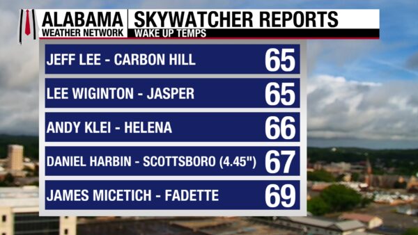
SPANN SKYWATCHERS
A damp and mild Saturday morning greeted Alabama as lingering clouds and saturated ground followed another round of heavy rainfall. Skywatchers checked in from the Tennessee Valley to the Wiregrass with several communities reporting multi-day rainfall totals over four inches.
- Jeff Lee – Carbon Hill – 65°
- Lee Wiginton – Jasper – 65.1°
- Andy Klein – Helena – 66°
- Daniel Harbin – Scottsboro – 67°
- Chris Cheatwood – Anniston – 68°
- James Micetich – Fadette – 69°



