


Daily Weather Briefing
Wednesday, June 17, 2026
ALABAMA THIS MORNING
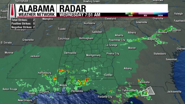
North through south-central Alabama is dry this morning, and clouds stretch across the sky. Meanwhile in south Alabama, pockets of showers cause many to wake to yet another rainy morning. Temperatures sit in the low 70s through the northern half of the state and the mid 70s in the southern half. It’s humid too, with dewpoints ranging from the upper 60s to low 70s north to the low to mid 70s centrally and in the south. Also, an Areal Flood Watch is in effect for the southern two-thirds of the state through Friday evening.
ALABAMA 7 DAY FORECAST
The northern half of the state will see a break from the rain today, while the southern half gears up for another wet day. Tomorrow, Potential Tropical Cyclone One and a cold front bring heavy rain, thunderstorms, strong winds, and the possibility for brief tornadoes to the entire state. More on that below. The front moves through all of Alabama by the end of Friday, keeping rainfall chances elevated, then a slightly more scattered rain pattern settles in for the weekend. Then an upper-level disturbance will increase rain chances for north Alabama next week, while rain chances in the south decrease.
MOSTLY DRY NORTH, SHOWERS SOUTH
Today is the break we need from the rain.
The northern half of Alabama sees only a 10% chance of showers and thunderstorms throughout the day today. If any rain falls, the showers will be short-lived and mostly in the late afternoon/early evening time. Any rain that falls will also favor north-central Alabama, while north Alabama should stay dry. Highs will climb to the upper 80s and even 90s degrees, despite mostly cloudy skies.
The southern half of the state will be rainy for sure but should be slightly less widespread than yesterday. A more scattered pattern with more breaks from the thunderstorms throughout the day is expected. A few storms could be strong and produce gusty winds at times, but nothing severe is anticipated. Highs will be limited to the mid 80s, with the upper 80s and low 90s still possible on the coast.
THURSDAY: RAIN, FLOODING, AND STORMS
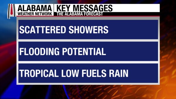
The remnants of Potential Tropical Cyclone One are expected to bring copious amounts of rain to the state of Alabama Thursday. As of right now, timing looks to stretch from the early morning to late evening, making it an all-day event. Impacts we’re watching as the system moves through are:
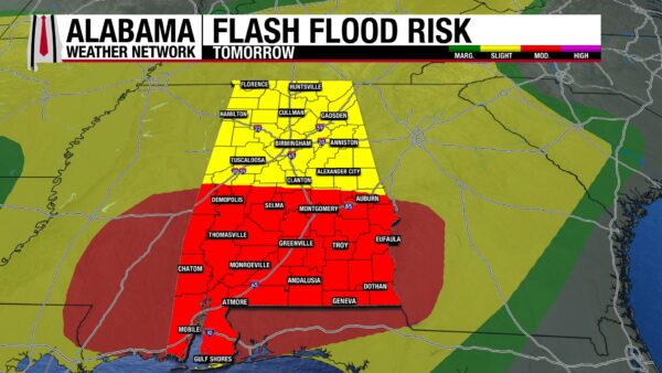
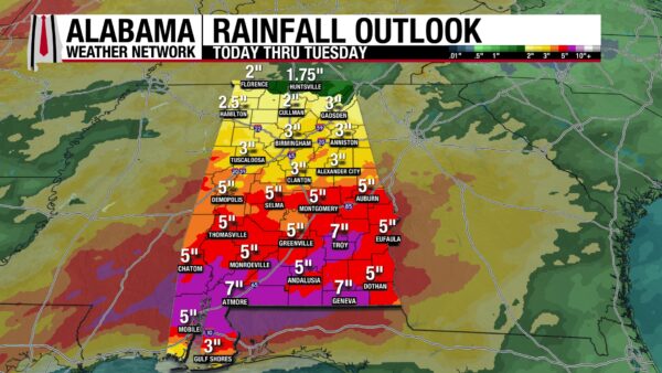
- Flooding: The system is supposed to bring the state at least 3-6″ of rain, with locally higher amounts possible. Given Alabama is already so wet, it will not take a lot of rain to cause flooding. And since we’re expecting so much rain, flooding is almost a guarantee. Have a flood plan in place today, especially if you live near a river or creek. If you have the ability to stay home, do so, but if you need to be out on the roads, remember: Turn Around, Don’t Drown! The Excessive Rainfall Outlooks are below, and we are especially concerned about south Alabama, as a Moderate Risk (3/4) for Excessive Rainfall is laid out for tomorrow.
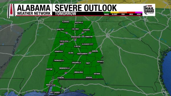
- Severe weather: A Marginal Risk (1/5) of Severe Thunderstorms spreads across Alabama tomorrow. Strong, gusty winds are the biggest concern, but brief isolated tornadoes cannot be ruled out with the unsettled atmosphere. Have a severe weather plan in place, one that includes a backup plan if your usual safe space is taking in water.
- Coastal flooding: On Alabama’s coast, flooding could occur as well. As of right now, minor inundation in usual flood spots such as Dauphin Island is possible.
Highs will sit in the upper 70s to lower 80s statewide.
It is important to stay weather aware tomorrow! The Alabama Weather Network will be monitoring the situation and will go live when warnings are issued.
FRIDAY’S FRONT
After Thursday, Alabama will be soaked, but it won’t be the end of the rain. A cold front associated with a low-pressure system to the northeast will move through Alabama starting late Thursday into Friday. More rain is expected, with a 70% chance of rain in the northern half of the state, and a 100% chance in the southern half. Highs will hit the mid 80s over the state.
PATTERN SHIFTS SATURDAY, RAIN STICKS AROUND
Some relief from the rain will come Saturday, especially for the northern half of Alabama as a brief ridge builds into the region. The rain chance in the region will only be 10%, and highs will be in the warm mid to upper 80s. The southern half of the state will still be wet, but only a 50% chance of thunderstorms is expected in the region. Mid 80s are expected in the area.
WET FATHER’S DAY FORECAST
After the rain break in the north, the rain chance jumps to 60% on Sunday. This is due to an upper-level disturbance that will approach the state, making for a wetter Father’s Day. Highs will be hot, with the upper 80s predicted.
The southern half of the state sees another day of a 50% chance of rain, and highs in the upper 80s to lower 90s.
WETTER IN THE NORTH TO START NEXT WEEK
As a relief to the southern half of the state, the higher rain chances start in the northern half of Alabama next week. A 70% chance is expected Monday and a 40% chance on Tuesday. The rain will keep the highs to the mid to upper 80s Monday and Tuesday. Meanwhile, the southern half of the state will only see a 20% chance of rain Monday and 30% chance Tuesday. What a difference compared to the rest of this week! Highs will hit the upper 80s and lower 90s each day as heat is anticipated to return.
RAINFALL OUTLOOK
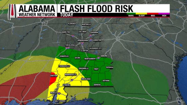
The flash flood risk is contained to the south today. A Marginal Risk (1/4) extends from the southeast to the northwest corner of south-central Alabama. A Sligh Risk (2/4) extends just north of Choctaw County, into Covington County, and through Mobile County. A Moderate Risk (3/4) reaches into the center of Washington County and clips the northwest corner of Mobile County. This small area could receive up to an inch and half of rainfall, on top of the almost 2” it got yesterday. Additionally, parts of this county have received more than 200% of the normal rainfall they get in the past 30 days (May 18-June 17). The area is already saturated and will have a difficult time receiving an inch and a half of rainfall.
Tomorrow, the northern half of the state will be under a Slight Risk for Excessive Rainfall (Flash Flooding), where a quarter of an inch to 2 inches of rain could fall. The southern half of the state will be under a Moderate Risk, where 2 to 4” of rain is anticipated to accumulate. Locally higher amounts are possible.
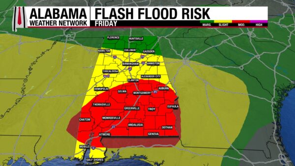
Friday sees three sections:
North Alabama will be under a Marginal Risk, only expecting up to half an inch.
Central Alabama and the southern half of the coast will be under a Slight Risk, as they’re predicted to receive three quarters of an inch to 2 inches of rain.
South Alabama will be under a Moderate Risk, with the possibility of seeing 2 to 2 and a half inches.
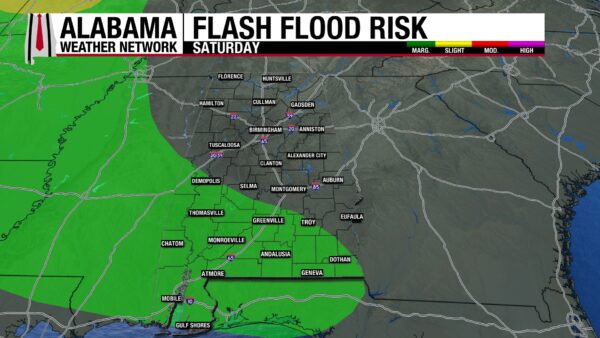
Saturday calms down a lot, and only a Marginal Risk of Flash flooding remains in the south.
All of this rain will add up to up to 7” by next week!
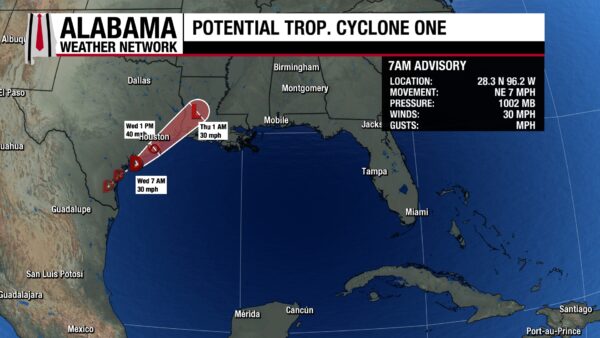
AWAITING TROPICAL STORM DEVELOPMENT IN THE GULF
The area of interest was upgraded to Potential Tropical Cyclone One yesterday and is expected to become a tropical storm this afternoon. It will take the name Arthur as the first named storm of the 2026 Atlantic Hurricane Season and is expected to impact Louisiana late tonight into tomorrow. A Tropical Storm Watch is in effect across the northern part of the Texas Coast while a Tropical Storm Warning is in effect on the Louisiana Gulf Coast. It will no longer be a tropical storm or depression by the time it rolls into Alabama, but it will drop lots of rainfall on the state regardless.
The area of interest in the Pacific has diminished.
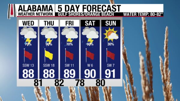
MORE RAIN ON THE BEACH
A 70% chance of showers and thunderstorms is in the beach forecast today, along with overcast skies, winds from the south at 15 mph, a Low UV Index, and a High rip current risk. The surf height is increasing, sitting at 3 to 4 feet right now as a High Surf Advisory is in effect until Friday evening. The high will hit the upper 80s. These conditions are expected to continue throughout the rest of this week as we watch the tropical system move through the Southeast.
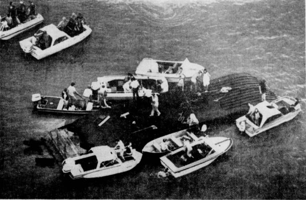
TODAY IN WEATHER HISTORY
June 17, 1978 – The Whippoorwill Disaster
On Saturday evening, June 17, 1978, the Whippoorwill Showboat pushed away from the dock on Pomona Lake in Osage County, KS, carrying passengers and crew into what was supposed to be a relaxing dinner-theatre cruise. It was a summer evening on the water, with families and friends aboard and the shoreline never seeming far away. But a severe thunderstorm watch was already in effect, and storm clouds were building across eastern Kansas. Around 7 p.m., the atmosphere turned dangerous quickly as a small tornado formed and began an erratic but generally eastward path of about eight miles toward the Michigan Valley area. It was not a massive Plains wedge tornado, but a compact and turbulent vortex. Witnesses described three funnels rotating around the main circulation, and the main tornado was only about 150 yards wide.
On land, the damage told the story of a relatively weak tornado. Campers, trees, power lines, and areas near the lake were damaged, but the tornado was rated F1; a classification usually associated with scattered structural damage rather than a major disaster. Over Pomona Lake, however, the same tornado found the worst possible target. As the funnel crossed the water, it struck very near the Whippoorwill and overturned the showboat, throwing some people into the lake and trapping others beneath the capsized hull. The scene changed in seconds from a dinner cruise to a desperate rescue. Other boaters and emergency responders rushed toward the overturned vessel, pulling survivors from the water as the storm moved away. The National Weather Service reported that 16 people died and three were injured among the 58 passengers and crew aboard. Though the deaths were drownings, they were attributed to the tornado because the vessel capsized in the tornadic winds.
The Whippoorwill disaster became the deadliest tornado in the United States in 1978 and remains one of the most unusual tornado tragedies in American weather history. Its significance was not in the tornado’s strength, width, or damage path, but in the vulnerability of what it struck. Many F1 tornadoes pass across open land and become brief local damage events. This one crossed a lake at the precise moment a crowded showboat was exposed on the water, where there were few safe options and little time to react. The tragedy at Pomona Lake stands as a sobering reminder that tornado risk is never measured by wind speed alone.
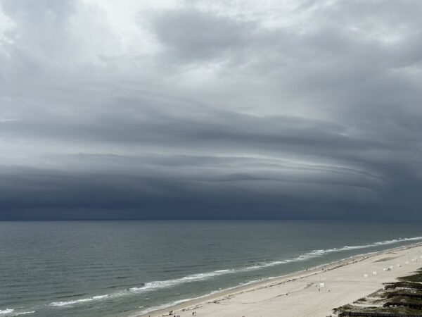
IMAGE OF THE DAY
Skywatcher Michelle Thomas took this picture of an awe-striking shelf cloud moving into Gulf Shores ahead of a Special Marine Warned storm yesterday evening!



