


Daily Weather Briefing
Sunday, August 2, 2026
ALABAMA THIS MORNING
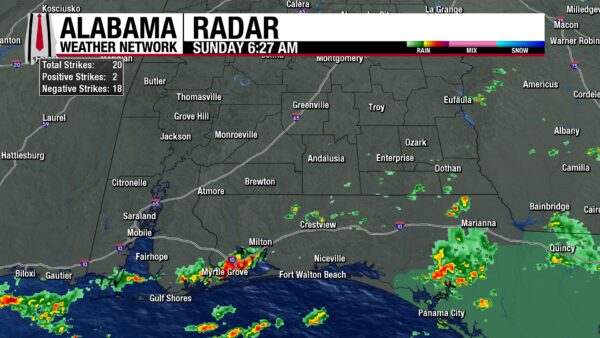
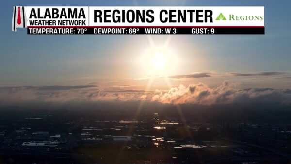
North and central Alabama wake to a relatively pleasant morning of partly cloudy skies and temperatures in the upper 60s in the north and lower 70s centrally. Dewpoints range from the mid 60s to lower 70s across the same region as well; the lower temperatures due to the passage of yesterday’s cold front. South Alabama is much warmer, with temperatures in the upper 70s and low 80s, cloudier skies, and some isolated showers. More specifically, coastal Alabama sees showers and thunderstorms over Coden, Alabama Port, and into Mobile Bay, and to the east over Miflin, Perdido Beach, and toward the Florida state line. Very isolated showers stretch from Samson to just north of Haleburg. The Birmingham Regions Center Skycam provides an amazing view of the beautiful sunrise featuring a bright sun and a low cloud deck!
ALABAMA 7 DAY FORECAST
Today will be drier across the state compared to yesterday, but rain chances aren’t gone completely. Tomorrow and Tuesday are similar, with highs mostly in the upper 80s. Rain chances stick around as an upper-level trough digs into the state and the Southeast. Wednesday through Friday will be back into the low 90s as an upper-level ridge to the west kicks the trough out of the region and rain chances stay scattered.
SCATTERED THUNDERSTORMS TODAY, STRONGER SOUTH – Aug 2
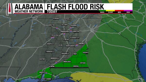
Showers and thunderstorms will be isolated to scattered today as the upper-level trough produces lift in the north and yesterday’s cold front keeps rain chances elevated south. Central Alabama should be mostly dry today, only a spotty shower or two possible. North Alabama could see showers pop up as the trough pushes into the region, with a focus on development in the northwest. South Alabama’s storm could be on the stronger side with gusty winds and frequent lightning possible, but severe weather is not expected. These storms will also produce heavy downpours, and a low risk of flash flooding exists for the region. Clouds and rain will keep highs limited to the low to mid 80s north, mid to upper 80s centrally, and upper 80s to lower 90s south.
SCATTERED SHOWERS FOR MONDAY AND TUESDAY- Aug 3-4
The upper-level trough will continue to hang out over the Southeast Monday and Tuesday, keeping rain chances in the forecast statewide, but low. Showers and thunderstorms will be isolated to scattered in nature on both days, and although lightning and heavy rain are expected, severe weather is not. Highs on Monday will reach the mid 80s north, upper 80s centrally, and upper 80s to low 90s south. Then as we head into Tuesday, highs increase to the upper 80s north, the upper 80s to lower 90s centrally, and low to mid 90s in the south.
ISOLATED TO SCATTERED SHOWERS FOR SECOND HALF OF WEEK – Aug 5-7
As we head into Wednesday and the latter half of this week, the upper-level trough will make its way out of the Southeast as the upper-level ridge to the west builds into the state.
On Wednesday, rain chances will be between 20-30% statewide, with scattered afternoon thunderstorms possible. Highs will hit the low 90s across Alabama.
On Thursday, rain chances will stay in the low to medium range, with any storms anticipated in the afternoon, with highs also in the low 90s.
Friday’s weather will change very little.
SCATTERED STORMS INTO WEEKEND – Aug 8
Rain chances look to stay the same on Saturday, and highs will stay in the low 90s.
RAINFALL OUTLOOK
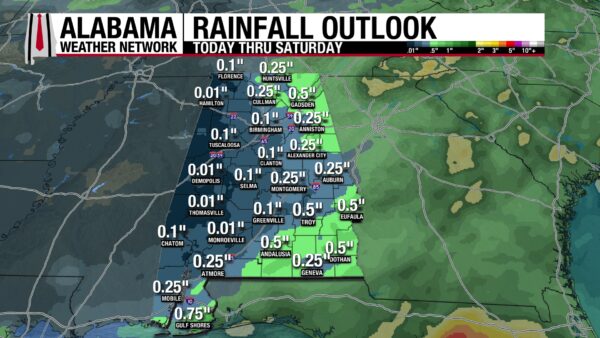
Rainfall amounts are relatively low over the next week, as our rain will be very scattered, and a widespread rain event is not in the forecast. Alabama could receive anywhere from less than a tenth of an inch in the western half of the state to up to half an inch of rain in the eastern half. With today’s southern storms, there’s a Marginal Risk (1/4) for Flash Flooding outlook for south Alabama.
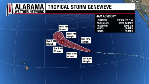
TROPICAL STORM GENEVIEVE SLOWLY LOOSES STRENGTH
Throughout this weekend, Tropical Storm Genevieve has slowly lost strength, and it will continue to do so through this week. As of this morning, it has sustained winds of 50 mph with a central pressure of 1003 mb. Tomorrow morning it will still be a tropical storm, but it will have winds of 40 mph, and by Tuesday morning it will be a tropical depression with sustained winds of 35 mph. It moves west-northwest and will not impact land.
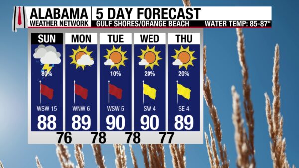
RAINY DAY AT ALABAMA’S COAST
An 80% chance of showers and thunderstorms is expected at the beach today. Storms will continue through this morning and into this afternoon, and are expected to end around 5 p.m. It shouldn’t be a total washout, but it will be rainier than the typical day on the Gulf Coast. It will also be mostly cloudy with breezy winds from the west at 15 mph, and a high in the upper 80s. Despite the mostly cloudy skies, the UV Index will be Very High. To accompany the not-ideal conditions on shore, the water is rough today, with a High rip current risk and surf heights of 3 to 5 feet. Rough waters continue through Tuesday, but land conditions improve tomorrow as the rain chance falls to zero.

WEATHERBRAINS 1072
Tomorrow’s WeatherBrains episode will feature Dr. Michael Peterson and Jessica Losego to spotlight the Georgia Tech Severe Storms Research Center. Listen to the episode wherever you get your podcasts or watch here.

TODAY IN WEATHER HISTORY
August 2, 1985 – Delta Flight 191
On August 2, 1985, Delta Air Lines Flight 191 was nearing the end of a Fort Lauderdale-to-Los Angeles trip with a scheduled stop in North Texas. The Lockheed L-1011 had 163 people aboard as it lined up for Runway 17L at Dallas-Fort Worth International Airport, where thunderstorms were developing near the north end of the field.
The aircraft descended into a rain shaft beneath a thunderstorm and entered a microburst. A microburst is a concentrated downburst of strong winds out of a storm that hits the ground and spreads outward. For an aircraft close to the ground, that kind of low-level wind shear can quickly steal airspeed and altitude.
Flight 191 first encountered a changing headwind, then a powerful downdraft and tailwind shift. The crew tried to recover, but the airplane descended below the glide path. At 6:05 p.m., it touched down short of the runway, crossed Highway 114, struck a car and a pole, then hit airport water tanks on airport property.
The crash killed 135 people, including 134 passengers and crew aboard the aircraft and 1 motorist on the ground. Twenty-nine people on the plane survived. It became one of the defining aviation-weather tragedies of the 1980s, showing that existing warning systems and cockpit training were not enough for microburst wind shear near airports.
Flight 191 came after a series of deadly microburst-related crashes, and its aftermath helped change aviation. Wind-shear training was strengthened, airborne detection and escape guidance improved, and ground-based Doppler radar systems were pushed forward at major airports. Flight 191 and other 1980s microburst crashes advanced better detection, warning, and training for wind shear.

IMAGE OF THE DAY
Skywatcher Michelle Miklik took a picture of bright mammatus clouds in Weaver last night!



