


Daily Weather Breifing
Saturday, August 29, 2026
ALABAMA THIS MORNING
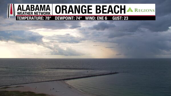
Skies are partly cloudy to mostly clear across most of Alabama, but clouds increase moving south. Temperatures are in the upper 60s north, low 70s over most of the rest of the state, and mid 70s in a few southern locations. The Orange Beach Regions Skycam captures a nice view of showers out over the water this morning.
ALABAMA 7 DAY FORECAST
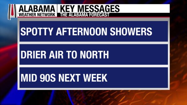
We enter a drier and hotter pattern this weekend, but the higher chance for rain this week is this weekend in the south, where scattered afternoon storms could develop each day. Otherwise, an upper-level ridge will build into the region throughout the next seven days, bringing hotter highs and lower rain chances.
DRYING OUT THIS WEEKEND – Aug 29-30
Today and tomorrow will see spotty showers across the state, as the northern half of the state will have a 10% chance of rain, and the southern half has a 30% chance. Any storms that do develop will form in the afternoon and evening on both Saturday and Sunday. The ridge’s influences will begin to impact west Alabama today, with the northern portions of the region reaching into the mid 90s. Across south Alabama, highs will be in the upper 80s, and over east Alabama highs will be in the low 90s. The same spread of temperatures is expected tomorrow.
HOT AND DRY TO END AUGUST AND REIN IN THE NEW MONTH – Aug 31-Sept 2
Hot and mostly dry conditions will settle well by Monday as the ridge settles into the Southeast. Rain chances will be at 10% across the northern half of the state and 20% over the southern half, meaning isolated afternoon and evening thunderstorms are possible Monday through Wednesday. Highs on Monday will range from the mid 90s in the northern two-thirds of Alabama to the low 90s in the south. Tuesday’s and Wednesday’s highs will do the same, but a few upper 90-degree readings are possible in west-central Alabama on Wednesday.
HOT PATTERN DOESN’T BUDGE TO END THE WEEK – Sept 3-4
The heat and dry weather will continue into the end of the week next week. Rain chances will drop off completely on Friday in the southern half of Alabama, but besides that, 10-20% statewide is expected. Highs will be in the mid 90s over the state both Thursday and Friday.
RAINFALL OUTLOOK
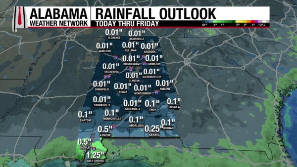
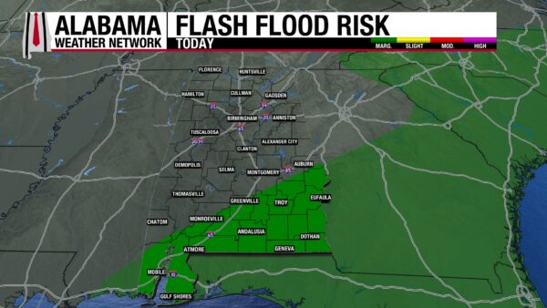
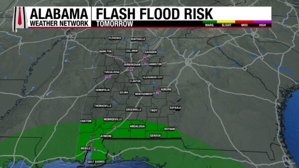
Rainfall averages over the next week will be very low across most of Alabama, only reaching a tenth of an inch, but not even that over the majority of the state. Coastal Alabama is the exception, as this weekend the region will see showers and thunderstorms in the region. Average rainfall accumulation in the region will range from 0.5″ to 1.25″ this week. Because of the expected southern storms, south Alabama is under a Marginal Risk (1/4) for Flash Flooding today and tomorrow.
FOOTBALL FORECAST
Today’s college football games will have great weather: temperatures in the upper 80s to low 90s and a very low chance of rain!
SOUTHERN DROUGHT EXTENDS FURTHER NORTH
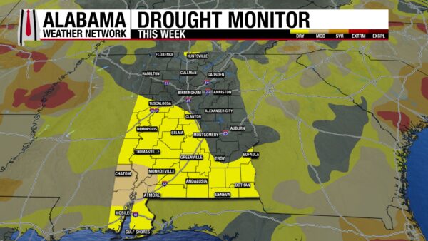
Over the past few weeks, we have watched drought conditions spread across south Alabama, and we are now watching it extend into portions of central Alabama. Last week, 34.62% of the state was experiencing Abnormally Dry (D0) Conditions, while 42.25% of the state is experiencing those conditions now. The good news is that the Moderate Drought (D1) area has not extended further. The drier pattern we are entering this weekend will not make these spreading conditions better.
THE ATLANTIC
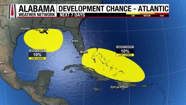
In the Atlantic, Tropical Storm Dolly has dissipated, but we are watching its remnants for possible redevelopment. The chance of it developing into a tropical system over the next 7 days is 10%. Additionally, a weak low in the Gulf responsible for this weekend’s showers over Alabama’s beaches has a 10% chance of tropical development.
THE PACIFIC
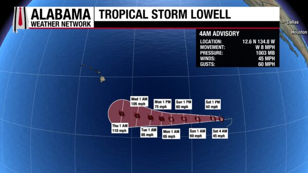
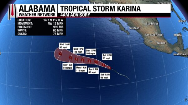
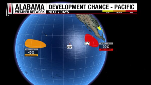
Tropical Storm Lowell has sustained winds of 45 mph and a central pressure of 1003 mb. It will move west at tropical storm strength until it is expected to reach hurricane strength Monday afternoon. Tropical Storm Karina has sustained winds of 65 mph and a central pressure of 989 mb. It is expected to strengthen to a Category 1 hurricane this afternoon, then to a Category 3 by Monday morning as it moves west-northwest. There are also two disturbances that could develop into tropical systems this week: the first is southwest of Hawaii with a 40% chance, and the second is closer to the Pacific Coast of Mexico and has a 90% chance of development.
RAINIER DAYS ON THE COAST
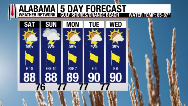
A weak low over the Gulf will provide the ingredients for showers and thunderstorms to develop on Alabama’s Gulf Coast this weekend and next week. There is a 50% chance of rain today, so washouts are expected, but periods of rain and storms are possible. The high will be in the upper 80s, skies will be partly sunny, the UV Index is Very High, and winds will be from the east around 10 mph. After very calm waters recently, the rip current risk today is Moderate, and the surf height will be around 1 to 2 feet.

TODAY IN WEATHER HISTORY
August 29, 2005 – Katrina Makes Landfall
Before sunrise on Monday, August 29, 2005, Hurricane Katrina was bearing down on the northern Gulf Coast. The hurricane had weakened from its extraordinary Category Five peak of 175 mph and 902 millibars the previous day, but its enormous circulation remained exceptionally dangerous. Katrina had undergone an eyewall replacement cycle, a process in which a new ring of thunderstorms forms around the original eyewall and eventually replaces it. This can temporarily weaken peak winds while expanding the hurricane’s wind field, and Katrina’s destructive winds and enormous storm surge covered a tremendous area as it approached the coast.
At approximately 6:10 a.m. CDT, Katrina made landfall near Buras in Plaquemines Parish, Louisiana. Post-storm analysis estimated maximum sustained winds near 125 mph, making Katrina a Category Three hurricane at landfall, with a central pressure near 920 millibars. The lower Mississippi River communities of Plaquemines and St. Bernard parishes were battered as water surged inland and hurricane-force winds tore through the region.
Katrina continued northward before making another landfall near the Louisiana-Mississippi border around 9:45 a.m., still a Category Three hurricane with winds near 120 mph. But along the Mississippi Gulf Coast, water became the storm’s most destructive weapon. Storm surge reached 24 to 28 feet across portions of the coastline, approaching 28 feet near Pass Christian and Bay St. Louis. Communities including Waveland, Gulfport, Biloxi and Pass Christian were overwhelmed as the surge swept buildings from foundations and carried wreckage far inland.
At the same time, another disaster was unfolding around New Orleans. Katrina’s surge overtopped portions of the hurricane protection system, while several levees and floodwalls failed. Water poured into neighborhoods, eventually flooding approximately 80 percent of the city. Some areas were submerged beneath many feet of water, leaving residents stranded inside buildings and on rooftops as rescue operations began under extraordinarily difficult conditions.
The Mississippi coast suffered destruction on a scale that recalled, and in places exceeded, Hurricane Camille in 1969. The surge reached 27.8 feet at Pass Christian, 25.7 feet at Long Beach and roughly 22 feet at Biloxi. Roads, bridges, casinos, homes and businesses were torn apart, and debris was carried far inland. Mississippi would ultimately record hundreds of deaths associated with Katrina, many caused by storm surge flooding.
Katrina remained powerful even after leaving the coast. The hurricane was still at hurricane strength well inland over Mississippi, while destructive winds, flooding and power outages spread through Mississippi and Alabama. Mobile Bay experienced a major surge as well, with water inundating portions of downtown Mobile and the waterfront. Katrina’s enormous circulation ensured that its effects extended far beyond the communities near the center.
The full scale of the disaster would take days to comprehend. Katrina ultimately became one of the deadliest and costliest hurricanes in United States history, but August 29 became remembered for more than the strength of the storm itself. The hurricane brought catastrophic wind and storm surge, while failures in levees, floodwalls, and other critical infrastructure magnified the suffering. Katrina’s destruction was compounded by infrastructure failures that made an already devastating disaster even worse.
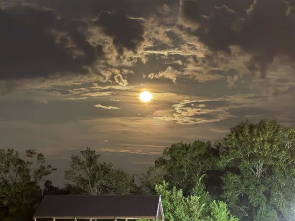
IMAGE OF THE DAY
Skywatcher Jonathan Aplin sent in this cool picture of the moonrise over Hope Hull last night!



