Daily Weather Briefing
Saturday, September 26, 2026
ALABAMA THIS MORNING
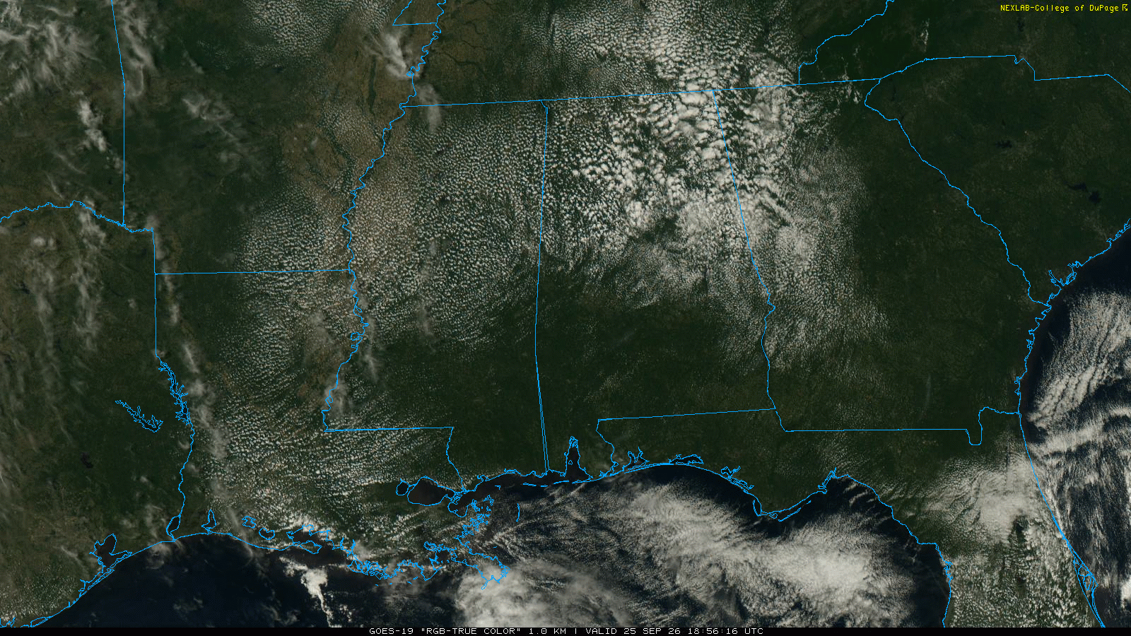
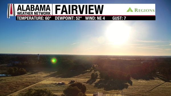
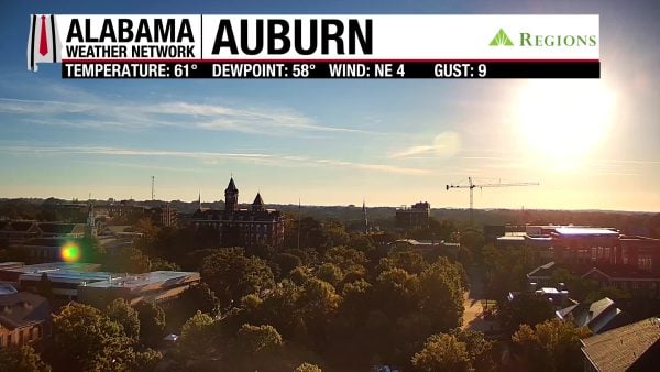
Skies are mostly clear this morning, and temperatures are in the comfortable mid to upper 50s in the north and eastern half of the state, and in the low 60s in the west. Our Regions Skycams display the bright sunrise on this Saturday morning.
ALABAMA 7 DAY FORECAST
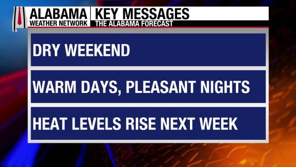
The cooler, dry pattern sticks around through tomorrow as the surface high pressure over the East (but not the Northeast) sticks around. As we head into next week, we’ll slowly return to warmer temperatures and a moister air mass as the upper-level ridge to our west spreads into the Southeast.
PLEASANT WEEKEND AHEAD – Sept 26-27
Today and tomorrow will be completely dry, with mostly sunny skies both days. Today will be the more fall-like of the two, with highs in the mid 80s across most of the state, with southwest Alabama flirting with the upper 80s. Tomorrow, the mid 80s will spread across the northern two-thirds of the state while the south sees a mix of the mid to upper 80s.
PATTERN SHIFT STARTS MONDAY – Sept 28-29
Monday will begin the pattern shift from the cooler, drier air to the warmer, moister air driven by the upper-level ridge that will cause southerly/southwesterly flow. This flow will advect (move) warmer temperatures and moister air into the state throughout next week, increasing rain chances and highs. Rain chances stay at 10% in the northern half of the state and 30% in the southern half, with any showers or storms forming in the afternoon and evening each day.
Highs on Monday will be in the mid 80s over north and north-central Alabama, while the upper 80s will dominate the southern two-thirds of the state.
If you’ve been enjoying the cooler weather, there’s some bad news. Highs on Tuesday will by mostly in the low 90s statewide, with parts of north and coastal Alabama barely hanging onto the upper 80s.
HOTTER AND MOISTER THROUGH FRIDAY – Sept 30-Oct 2
Through the rest of the week, conditions won’t change much as highs will be similar each day and rain chances will be the same as Monday and Tuesday’s. Rain chances on Friday in the south dip to 10%.
On Wednesday, highs will be in the low 90s with a few upper 80-degree readings sneaking around in the south.
Thursday will feature a better balance between the upper 80s and lower 90s.
The upper 80s and lower 90s will be the high temperature range for Friday as well.
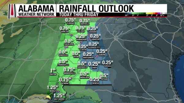
RAINFALL OUTLOOK
Expected rainfall amounts over the next week have increased, but most of the rain that will drop this number will not happen until Thursday and Friday. When this rain comes, it is expected to drop half an inch to an inch of rain on the western half of the state, while the east will stay drier with a quarter of an inch of rain. These numbers are averages, and locally higher amounts underneath a shower or storm are possible.
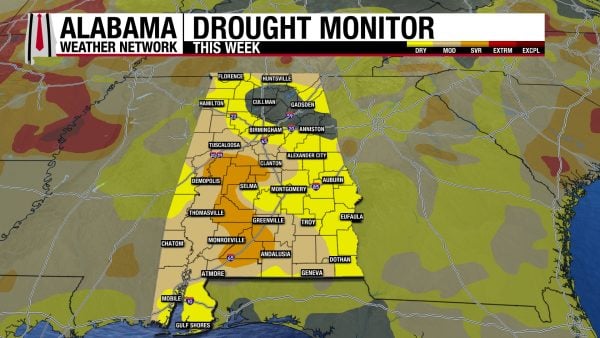
DROUGHT CONTINUES TO WORSEN
Over the past week, each drought category has expanded across Alabama, with more of the southwest experiencing Severe Drought (D2) conditions, more of the southeast and north experiencing Moderate Drought (D1) conditions, and more of the north/north-central region experiencing Abnormally Dry (D0) conditions. Our relatively dry week, sprinkled with scattered showers, will only continue to exacerbate these conditions.
FOOTBALL FORECAST
After a scorching, stormy first few weeks of college football, temperatures will be much less oppressive, and rain is out of the picture. It will still be sweat-worthy in the stadiums, but fans should be able to head home less drenched.
UAB VS. NAVY
UAB hosts Navy today at 6:00 p.m. CDT at Protective Stadium. The sky will be clear, with temperatures falling from near 83 at kickoff into the 70s during the second half.
AUBURN VS. VANDY
Auburn hosts Vandy today at 3:15 p.m. CDT at Jordan-Hare. The sky will be sunny with temperatures in the low to mid 80s.
ALABAMA VS. SOUTH CAROLINA
Alabama will play South Carolina tonight in Tuscaloosa with a 6:00 p.m. CDT kickoff. Expect a clear sky with temperatures falling from the low 80s at kickoff into the 70s during the second half.
MORE HOME GAMES
Jacksonville State, Alabama State, North Alabama, and Samford all have home games; today will be dry statewide, with a high in the 80s. Temperatures come down into the 70s soon after sunset.
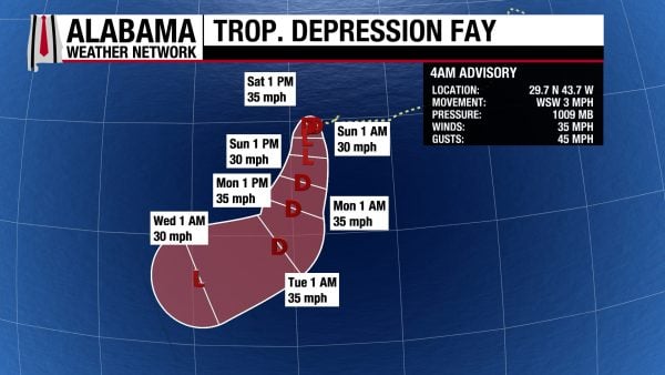
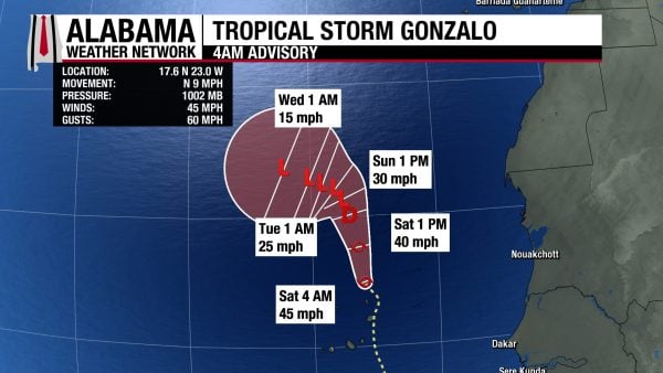
THE ATLANTIC
In the Atlantic, Fay has transitioned to Tropical Depression strength, with sustained winds of 35 mph and a central pressure of 1009 mb. As it moves south over the next few days, it will teeter between a tropical depression and a post-tropical depression. Tropical Storm Gonzalo has sustained winds of 45 mph and a central pressure of 1002 mb. It continues to move north-northwest and will manage to stay a tropical storm until tomorrow, when it will transition to a tropical depression.
THE PACIFIC
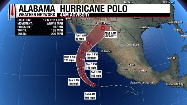
Hurricane Polo, still a Category 5 storm, is expected to take a northeastward turn in the coming days as it slowly weakens. By Monday night, it will make landfall in the Baja California Peninsula as a Category 1 or 2 hurricane. Then it will move across northwestern Mexico throughout the day on Tuesday. Tropical Storm conditions are possible in the region by Sunday night, then Hurricane conditions will begin Monday night, meaning tropical storm-force and hurricane force-winds are capable of beginning at those times. Portions of Baja California Sur will receive 4-8″ to up to 10″ of rain, which could lead to flash flooding and mudslides. Storm surge and large swells are expected as well.
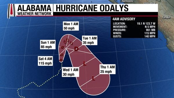
Hurricane Odalys, a Category 2 storm, has sustained winds of 115 mph and a central pressure of 951 mb. It will move north and stay a hurricane until Sunday afternoon, when it will transition to a tropical storm and make a southeastward turn.
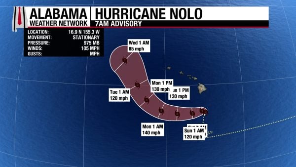
Hurricane Nolo is a Category 2 storm that will be intensifying this weekend. Although it will stay well offshore of the Hawaiian Islands, they will not be spared from impacts. A Hurricane Watch and a Tropical Storm Warning are in effect for Hawaii County, while a Tropical Storm Watch is in effect for Maui County. Tropical storm-force winds are impacting Hawaii County now and will continue to do so today. For the eastern and southern portions of the Big Island, Nolo will produce 8-12″ of rain with locally higher amounts of 16″ this weekend. This will lead to flash flooding and mudslides. The western portion of the Big Island will see 1-3″ of rain with a max of 6″, and eastern Maui will receive 4-6″ to up to 8″ of rain. The rest of the islands can expect 1-2″ of rain. Storm surge of 1-3 feet is possible, and large, dangerous surf will impact the islands this weekend too.
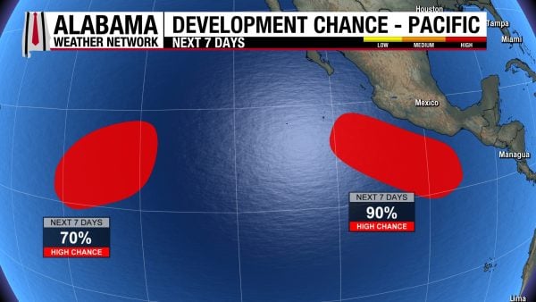
Two disturbances are being monitored for tropical development, with one off the coast of Mexico with a 90% chance of development and one well east-southeast of the Hawaiian Islands with a 70% chance.
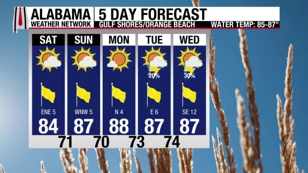
CALM BEACH CONDITIONS THIS WEEKEND
Conditions on Alabama’s Gulf Coast will be calm this weekend. Today, the high will be in the mid 80s, skies will be mostly sunny, and winds will blow from the east-northeast at 5 mph. The rip current risk is Low, and the surf height is around 1 foot. No rain is expected. Similar conditions persist through tomorrow and even Monday before rain chances return to the forecast.
TODAY IN WEATHER HISTORY
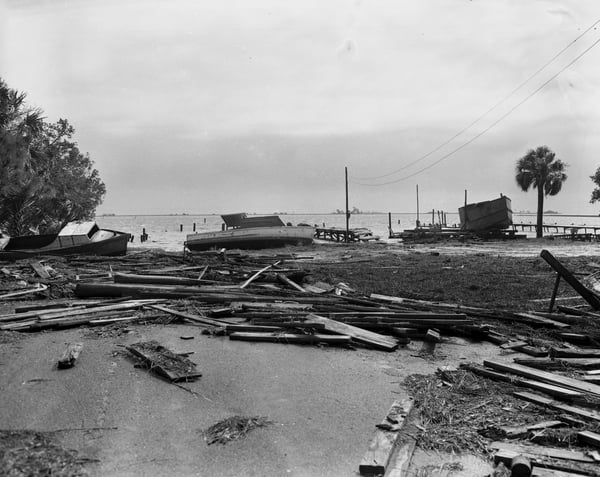
September 26, 1953- Hurricane Florence
Hurricane Florence began as a tropical wave moving across the Caribbean, organizing southeast of Jamaica before becoming a tropical storm. It strengthened quickly through the Yucatán Channel, reached hurricane intensity, and became a major hurricane over the Gulf of Mexico with peak winds later analyzed near 115 mph. But as Florence approached the northern Gulf Coast, cooler water and cooler air began taking a toll, weakening the storm considerably before landfall.
By the morning of September 26, 1953, Florence was approaching a much more sparsely populated Florida Panhandle than exists today. The hurricane came ashore between Fort Walton Beach and Panama City Beach as a minimal Category 1 hurricane, with sustained winds estimated near 80 mph. Because the center crossed a relatively undeveloped section of coastline with few weather instruments, the strongest conditions near the eye were never directly measured. Eglin Air Force Base, west of the landfall point, recorded a wind gust of 84 mph.
Preparations were significant for the era. Thousands of people left vulnerable areas around Panama City, military aircraft were moved away from the threatened coast, and Coast Guard personnel traveled along beaches warning residents of the approaching hurricane. Despite Florence’s earlier strength over the Gulf, its weakening before landfall and passage through a lightly populated area kept the wind damage relatively limited. Trees and utility lines came down, roofs were damaged, and agricultural losses mounted across northwest Florida and southeastern Alabama.
The most remarkable part of Florence was the rain. A frontal boundary interacting with the hurricane helped focus the heaviest precipitation north and west of the storm’s track, an unusual distribution that placed southeastern Alabama beneath repeated bands of tropical rainfall. Lockhart, Alabama, near the Florida state line, recorded 14.71 inches — the highest documented storm total from Florence anywhere in the United States. Some rainbands produced rainfall rates greater than an inch and a half per hour.
The deluge spread well beyond Lockhart. Montgomery recorded 8.72 inches, flooding homes and automobiles as drainage systems were overwhelmed. Across southeastern Alabama, winds generally averaged 30 to 40 mph with gusts reaching 50 to 60 mph, but the combination of wind and soaking rain caused more than $3 million in crop losses, an enormous agricultural blow in 1953. Florence rapidly weakened after moving inland and transitioned into an extratropical system as it crossed the Southeast.
Historical accounts differ on some of Florence’s damage totals. Contemporary reports cited during later hurricane reanalysis described relatively modest structural losses in northwest Florida, while later histories produced substantially higher numbers for destroyed and damaged homes in some coastal counties. What is far clearer in the surviving meteorological record is where Florence left its most distinctive fingerprint: not in extreme winds along the beach, but in nearly 15 inches of rain across southern Alabama. It was a reminder, decades before modern radar and rainfall forecasting, that a hurricane’s greatest threat does not always arrive with its strongest winds.
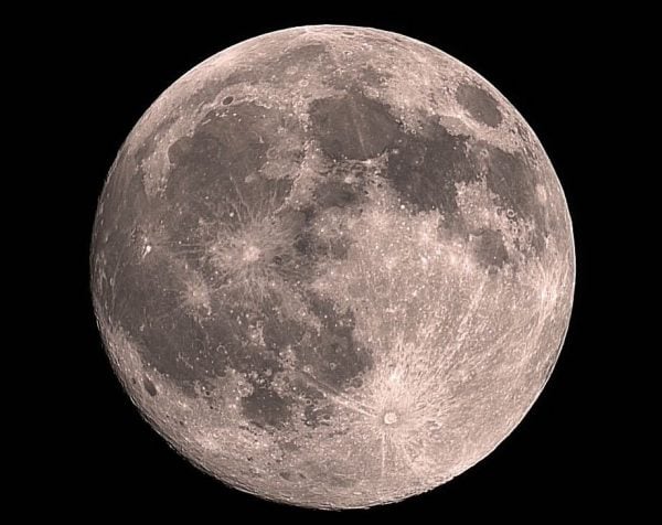
IMAGE OF THE DAY
Skywatcher Daniel Harbin captured the 99% illuminated moon last night. How beautiful!