ISAIAS GROWING STRONGER: Tropical Storm Isaias this afternoon has sustained winds of 50 mph, and is about 520 miles south/southwest of the mouth of the Mississippi River. It is moving to the east/northeast at 8 mph. The latest NHC forecast track pushes Isaias into the Central Gulf Coast around midnight Friday night with sustained winds of 90-95 mph. The circulation then moves quickly through West Alabama during the day Saturday.
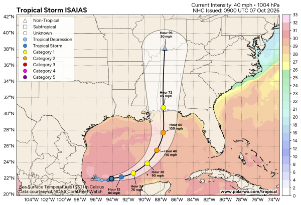
Here are the key messages this afternoon
*A Hurricane Watch is in effect for the northern Gulf Coast from Bay St. Louis, Mississippi to Indian Pass, Florida. This includes all of the Alabama Gulf Coast.
*On the latest forecast package, NHC nudged the track a little to the east, showing landfall near Perdido Key Friday night around midnight. Winds at the time of landfall are still expected to be in the 95-100 mph range. As you look at the maps, remember a hurricane is not just a dot or a skinny black line. Wind and rain impacts will extend far from the center, mainly on the eastern side of the system.
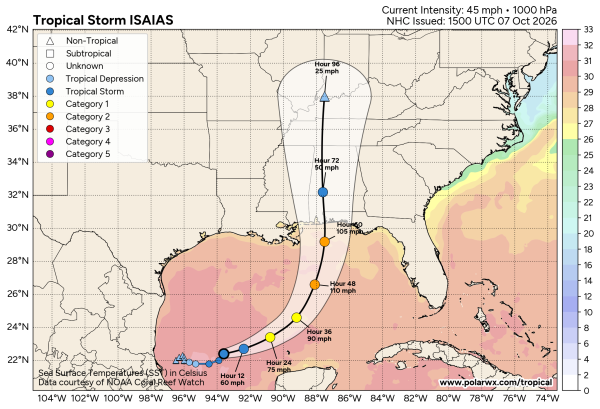
*A five to seven foot storm surge is forecast for the Alabama coast and Mobile Bay.
*Rain amounts could exceed 6 inches along the coast Friday through Saturday morning. The most significant rain and wind on the coast will come from 12 noon Friday to 12 noon Saturday.
*Saturday will be a windy, wet day for inland Alabama. Rain amounts of 2-4 inches are possible over the western half of the state, with 1-2 inches over North and East Alabama. Winds could gust to 40/50 mph over West Alabama as Isaias moves northward.
*A few tornadoes are possible Saturday morning, mainly over the southern half of Alabama.
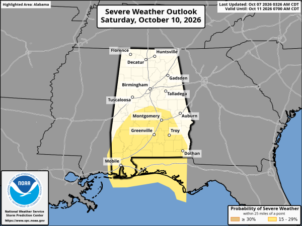
*Models continue to trend faster. A good chance much of the rain will be over in time for the Alabama/Georgia game in Tuscaloosa, and the Zach Bryan concert in Auburn. There will still be a risk of showers at both venues, but not the widespread rain we will experience Saturday morning.
*The weather improves on the coast by late Saturday morning with a clearing sky and diminishing wind. The rest of the weekend and all of next week will be dry.
*Rain will move out of North Alabama Saturday night, and Sunday will be warm and dry statewide.
And, remember, with any tropical system forecast changes are likely, so keep up with the latest updates.
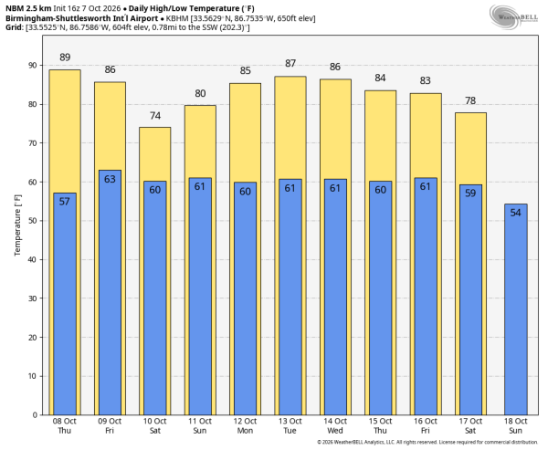
At this point next week looks dry with warm afternoons… highs in the 80s. See the video briefing for maps, graphics, and more details.
ON THIS DATE IN 2016: Hurricane Matthew was off the northeast coast of Florida. Matthew brought intense rainfall to the Carolinas on the 8th and 9th.
Look for the next video briefing here by 6:00 a.m. tomorrow…