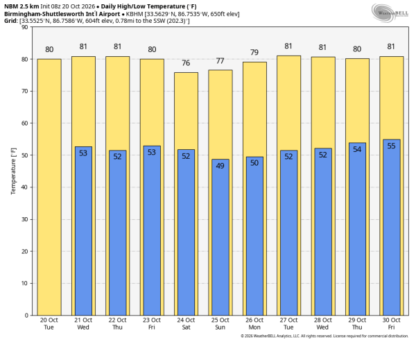
DRY DAYS: Weather like this means our job pretty easy; a dry pattern will continue across Alabama through the weekend with sunny pleasant days and clear cool nights. Afternoon highs will be close to 80 degrees through Friday, then in the mid to upper 70s over the weekend. Morning lows will hold in the upper 40s and low 50s for most communities.
And, no real change next week as dry weather continues across Alabama and the Deep South. It continues to look like our next meaningful rain event will come in early November. See the video briefing for maps, graphics, and more details.
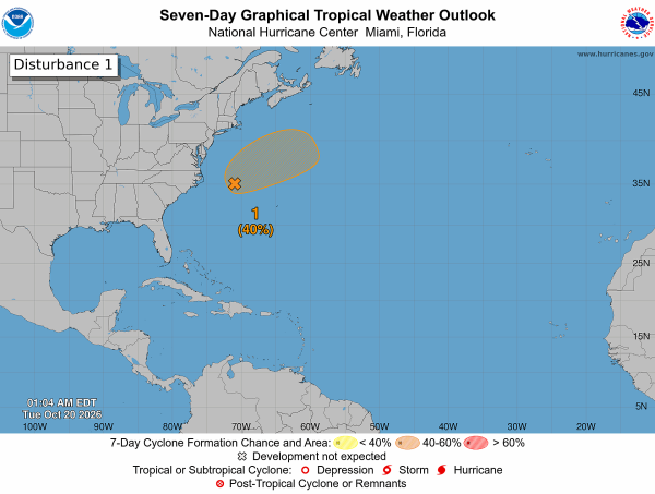
TROPICS: A storm-force non-tropical low pressure area (Invest 93L) remains attached to an occluded frontal boundary a few hundred miles off the North Carolina coast in the Atlantic. This low could develop some organized deep convection and gradually lose its frontal features over the next couple of days while it moves slowly north-northeastward over the Gulf Stream. By the end of the week, the system is expected to accelerate northeastward away from the the eastern United States, where environmental conditions are expected to become unfavorable for subtropical or tropical development.
Regardless of the status of the system, high winds, coastal flooding, and dangerous surf are expected along portions of the U.S. East Coast during the next few days. Chance of this becoming a sub-tropical storm is 40 percent.
The rest of the Atlantic basin is quiet, and tropical storm development is not expected in the Gulf for at least the next 7-10 days.
RACE WEEKEND: The weather could not be better for race weekend at Talladega. Sunny, comfortable afternoons, clear, cool nights. Afternoon highs in the mid to upper 70s, morning lows in the upper 40s and low 50s.
FOOTBALL WEATHER: Auburn hosts LSU Saturday at Jordan-Hare Stadium (11:00a CT kickoff)… the sky will be sunny with temperatures rising from near 73 at kickoff to around 76 degrees by the final whistle.
Alabama will host Texas A&M Saturday (2:30p CT kickoff)… a sunny sky over Tuscaloosa with temperatures in the mid 70s for the first half, falling into the upper 60s by the end of the game.
ON THIS DATE IN 1983: Remnants of Pacific Hurricane Tico caused extensive flooding in central and south central Oklahoma. Oklahoma City set daily rainfall records with 1.45 inch on the 19th, and 6.28 inches on the 20th.
I am at the National Weather Association annual meeting in Omaha, so just one video briefing today. I will post new forecast notes this afternoon… enjoy the day!