


Daily Weather Briefing
Saturday, November 7, 2026


ALABAMA THIS MORNING
Alabama starts the day in the mid 40s to low 50s in the north, the upper 40s to low 50s centrally, and the low to mid 50s in the south. Skies are partly cloudy, and our Regions Skycam in Hoover shows off a peaceful view!
ALABAMA 7 DAY FORECAST
The biggest weather story of the week is this weekend’s and next week’s cold morning temperatures. Otherwise, Alabama will be pleasant and dry through the period thanks to upper-level ridging and surface high pressure.
NICE AUTUMN WEEKEND – Nov 7-8
Today and tomorrow will be pleasant autumn days with no rain, cold mornings, and comfortable highs.
After today’s chilly morning, highs will reach the low to mid 60s north, mid 60s centrally, and mid 60s to low 70s south. Skies will be partly to mostly cloudy.
Tomorrow morning will be even cooler, with lows falling to the mid 30s north and upper 30s to low 40s across the southern two-thirds of the state. Frost is possible in the northern half of the state, so bring plants and pets inside tonight. Highs will climb to the mid 60s north an upper 60s to low 70s over the rest of the state. Some clouds are expected tomorrow also, but they are more likely over the southern half of the state.
QUIET BEGINNING TO WEEK – Nov 9-11
Little will change in the forecast next week, and comfortable weather will continue.
Monday morning will be chilly rather than comfortable as lows will range from the mid 30s north, mid to upper 30s centrally, and upper 30s to low 40s south. Skies will be partly to mostly cloudy, with the higher cloud cover chance in the south. Afternoon highs will warm to the upper 60s to low 70s north and low to mid 70s over central and south Alabama.
Tuesday’s temperatures will start in the 40s statewide, then reach into the upper 60s north and mid 70s south.
As Wednesday rolls around, lows will be in the 40s across Alabama again, then highs will be in the same spread of upper 60s to low 70s north to mid 70s south.
PLEASANT CONDITIONS CONTINUE – Nov 12-13
Thursday morning won’t be as cold, as temperatures will only fall to the upper 40s to low 50s in Alabama. Highs, however, won’t get as warm as the low to upper 60s spread from north to central Alabama, and the low to mid 70s are expected in the southern half of the state.
The 30s return on Friday morning with a low temperature spread from the mid 30s to the mid 40s. Friday’s highs will be limited to the cool mid to upper 50s north, upper 50s to low 60s in central Alabama, and the low to mid 60s south.
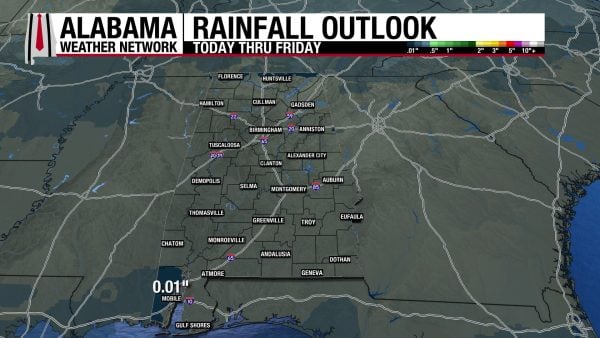
RAINFALL OUTLOOK
Alabama will be dry over the next 7 days, although there is a chance a trace amount of rain may fall in the most northern area of the state and in coastal Alabama.
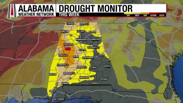
SLIGHTLY IMPROVED DROUGHT CONDITIONS
The rain Alabama received last week provided a little bit of drought relief to the state, mostly in the north. 0.41% of Alabama is under Extreme Drought (D3) conditions, compared to 1.52% last week. 10.22% of Alabama is under Severe Drought (D2) conditions, compared to 13.22% last week. Our dry week ahead will only reverse the progress made.
FOOTBALL FORECAST
AUBURN VS. ARKANSAS
Auburn hosts Arkansas at Jordan-Hare Stadium at 11: 45 a.m. CST this morning. The sky will be sunny with temperatures in the 60s.
ALABAMA VS. LSU
Alabama will be in Baton Rouge to play LSU at 2:30 p.m. CST this afternoon. It will be a sunny day there with temperatures in the mid 70s during the first half, falling into the upper 60s by the final whistle.
OTHER HOME GAMES
The weather looks excellent for all of the games across Alabama and the Deep South today and tonight.
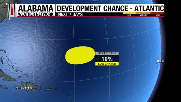
THE ATLANTIC
The area of low pressure the National Hurricane Center has been watching has a 10% chance of taking on tropical characteristics tonight before it becomes non-tropical as it moves eastward over the coming days.
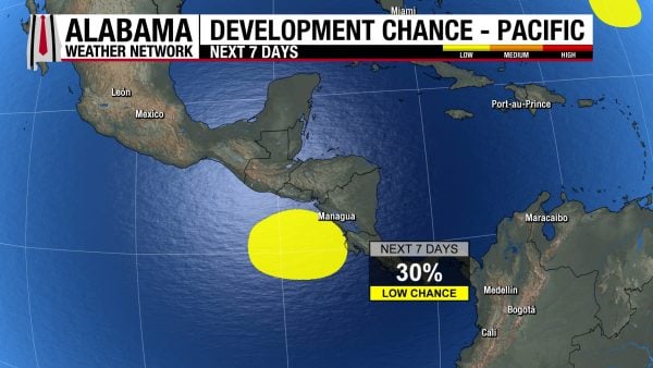
THE PACIFIC
Tropical Storm Pena has formed in the Pacific and will move westward over the coming days before finally becoming a Category 1 hurricane by Wednesday.
The area of low pressure off the coast of Central America has a 30% chance of development, as it is expected to encounter unfavorable conditions this week. Regardless, it will bring periods of heavy rainfall for Central America as it moves northward.
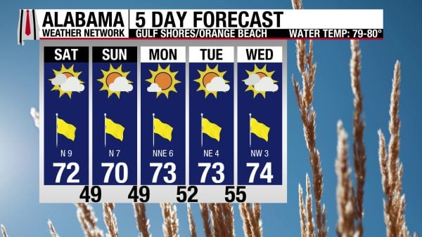
FALL ON THE COAST
Alabama’s Gulf Coast will experience a nice stretch of fall weather. Today and the next few days will see a high in the low 70s, partly to mostly sunny skies, winds from the north up to 10 mph, and a Moderate UV Index. The rip current risk will be Low, and the surf height is around 1 foot.
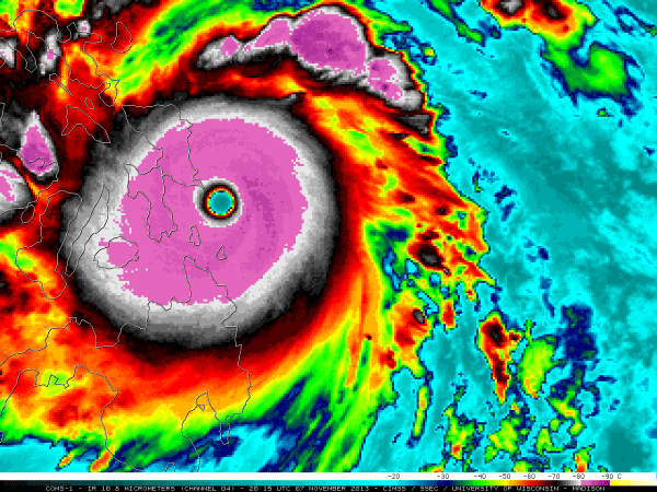
TODAY IN WEATHER HISTORY
November 7, 2013 – Super Typhoon Haiyan
On November 7, 2013, Super Typhoon Haiyan, known locally in the Philippines as Yolanda, reached extraordinary intensity as it raced westward across the Philippine Sea toward the central islands of the country. Fueled by exceptionally warm ocean waters and favorable atmospheric conditions, the massive cyclone developed sustained winds estimated at 195 mph, with gusts approaching 235 mph. Its central pressure fell to approximately 895 millibars according to the Japan Meteorological Agency, placing it among the most intense tropical cyclones ever recorded. The Joint Typhoon Warning Center estimated winds equivalent to a high-end Category 5 hurricane, making Haiyan a contender for the strongest tropical cyclone ever to strike land. Shortly before 4:45 a.m. local time on November 8, corresponding to the evening of November 7 in the United States, Haiyan’s enormous eyewall slammed into the eastern Philippines near Guiuan on the island of Samar. The storm arrived with such overwhelming force that weather instruments failed, communications disappeared, and entire communities were plunged into a catastrophe of historic proportions.
As Haiyan crossed the islands of Samar and Leyte, its devastating winds tore roofs from buildings, snapped trees, overturned vehicles, and flattened entire neighborhoods. But the hurricane-force winds were only part of the disaster. The storm drove an enormous surge of seawater into the shallow waters of Leyte Gulf, where the shape of the coastline and underwater topography helped concentrate the flooding. In Tacloban, a coastal city of more than 200,000 residents, the water rose with extraordinary speed, inundating densely populated neighborhoods. Post-storm surveys documented surge heights near 23 feet in portions of the city, with even higher water levels reported in some early assessments. Residents described walls of seawater sweeping through streets, carrying houses, vehicles, and enormous quantities of debris inland. Ships were driven ashore, concrete buildings were damaged, and entire coastal communities disappeared beneath the violent floodwaters. In some neighborhoods, residents had only moments to escape as the sea surged into homes and buildings where families had sought shelter.
The destruction in Tacloban was catastrophic. Thousands of homes were swept away, leaving behind vast fields of debris, broken lumber, twisted metal, and shattered concrete. The city’s airport was heavily damaged, roads were blocked, and electrical and communication networks collapsed. Hospitals struggled to function as injured residents arrived seeking treatment, while emergency responders faced enormous difficulties reaching isolated communities. Across Eastern Samar, the towns of Guiuan, Hernani, and neighboring coastal settlements suffered similarly severe destruction. In several locations, the combined effects of violent winds and storm surge left little standing near the shoreline. Families were separated during the flooding, and survivors searched desperately for missing relatives among the wreckage. Even buildings designated as evacuation shelters were overwhelmed in some areas, revealing the extraordinary danger posed by a storm surge far beyond what many residents had previously experienced.
As the typhoon continued westward across the central Philippines, additional communities suffered devastating wind damage, flooding, and landslides. Haiyan eventually crossed six Philippine islands before emerging into the South China Sea, leaving an enormous humanitarian emergency in its wake. More than 16 million people were affected, and approximately four million were displaced from their homes. The Philippine government ultimately confirmed about 6,300 deaths, with more than 28,000 people injured and over 1,000 still missing in the months following the disaster. More than one million homes were damaged or destroyed, while economic losses were estimated in the billions of dollars, with some broader assessments placing the impact near $14 billion. International relief organizations, military forces, and humanitarian agencies mobilized massive operations to deliver food, clean water, medical supplies, and temporary shelter. However, destroyed roads, damaged airports, and the collapse of communications made reaching the hardest-hit communities extraordinarily difficult.
Super Typhoon Haiyan became one of the defining natural disasters of the twenty-first century and the deadliest typhoon in modern Philippine history. Its estimated 195 mph sustained winds placed it among the strongest tropical cyclones ever documented at landfall, while its devastating storm surge demonstrated how coastal geography can amplify the destructive power of an already extreme storm. The catastrophe prompted renewed attention to storm surge forecasting, evacuation planning, resilient construction, and public understanding of tropical cyclone hazards. It also highlighted the particular vulnerability of densely populated coastal communities, where rapidly rising seawater can prove even more deadly than the hurricane’s winds. For the people of Samar, Leyte, and Tacloban, the legacy of Haiyan extended far beyond meteorological records. It was measured in lives lost, families displaced, communities rebuilt, and the extraordinary resilience of survivors who faced one of the most powerful storms ever to cross the Philippine coastline.

IMAGE OF THE DAY
Skywatcher Ryan Hoffman captured a single-sided sun dog in Inverness yesterday.



