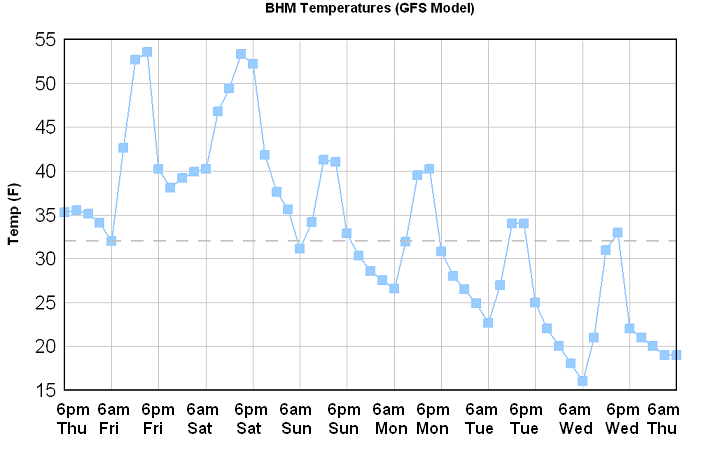
After one of the coldest Januarys on record, and one of the hottest and longest summers, here come the extremes again! December has already started out cold…with lows in the 20s across much of Alabama this morning (it was in the mid 20s in parts of the FL panhandle). But, a very cold air mass is gathering over Alaska and Canada late this week, and it will head south into the U.S. this weekend, reaching Alabama on Monday. Check out current temperatures in Alaska and western Canada.
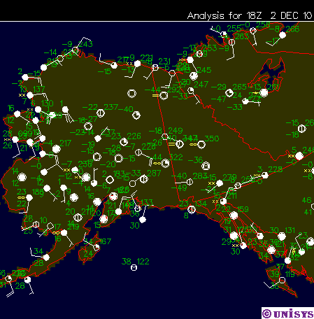
There are a lot of below zero temperatures, including a -40. This often happens when we have a warm autumn (80s well into late October). The air in the Arctic was not coming south and being replaced by warmer air, but it was, instead, sitting and getting colder. At some point, the temperature contrast becomes to great and it has to move, and that time is now.
The GFS was a little too cold on the last cold outbreak (it was 42 instead of 35 during the Iron Bowl), but the general idea is the same. Notice in the graphic at the top of this blog that we have highs in the 50s Saturday, 40s Sunday, and only 30s by Tuesday and Wednesday, according to this model. This time, it’s not just a quick shot of cold air, but a large cold air mass settling across the eastern US, with reinforcing shots of cold air about every 24 hours. Some locations may drop into the teens, especially north of I-20, and with daytime highs only 35 to 40, we could have 12 hours below freezing each day. This is pipe-freezing, pet-dangerous weather. There will also be a north wind, producing wind chills in the 20s even during the day.
The Canadian model agrees with this scenario, but even if the more moderate European model is right, we’re in for some of the coldest early-December air on record. Get ready!