


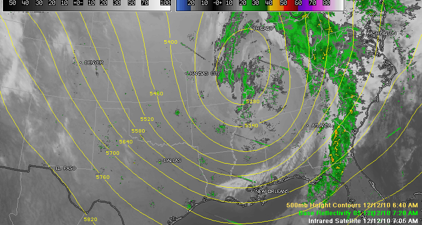
You can really see the source of our problems this morning, in the form of this powerhouse of an upper low that is over Illinois. It has been dropping southeastward.. It should peak about lunchtime today as it starts to turn more eastward.
Radars from Tulsa to Fort Smith to Memphis to Columbus MS are starting to show an increase in echoes indicating that the light snow in their areas is picking up a tad. From the NWS Jackson chat, we saw a report that flurries were starting to reach the ground in Kosciusko, MS.
There are probably a few flurries falling in Starkville over to south of Columbus MS. A slightly heavier flurry was aimed at Carrollton in Pickens County, Alabama. This activity could affect Tuscaloosa within the hour. A late report from Eric Law at WLBT in Jackson confirms snow flurries in the Starkville/Ackerman area.
Ronald Hughes in Coker reported a few flakes at 7:38 a.m.
Snow showers will continue throughout the day. Some areas could see heavier snow bursts, but generally no accumulation is expected. It will be cold and windy with temperatures falling to and holding steady around freezing most of the day. Northwest winds at 15-25 mph gusting to 30 and higher will make it feel like it is in the teens. And be alert for any standing water on roads that will freeze, causing patches of black ice. Get ready for a hard freeze tonight, with lows around 17. Lows Monday night will be even colder, averaging around 14F, with single digit sin the normally colder locations.
Once we go below freezing here at Birmingham, we may not see 32F until around noon on Tuesday.
Still monitoring the possibility of some freezing rain Wednesday morning over the northern half of the state. The evening run of the GFS delayed the onset of the precipitation, which makes sense because the air is really going to be dry and will take some time to moisten. The overnight run was a little more bullish on the idea of there being some freezing precip between 6-9 a.m. Wednesday. So this idea is one we will have to continue to watch.
But for now, the story is the cold. Think about steps you need to take today to protect the 4 Ps: people, pets, plants and property from the extremely cold temperatures.
LATE NOTES FROM MINNEAPOLIS
Our John Brown passed on a report that the roof of the Metrodome in Minneapolis has collapsed. That is confirmed through news reports. Minneapolis recorded the most ever snow on a December day with 16.5 inches yesterday. The NFL game there today had already been postponed until tomorrow night and may be delayed further, but thank goodness the snow and collapse didn’t come during a live event there.



