


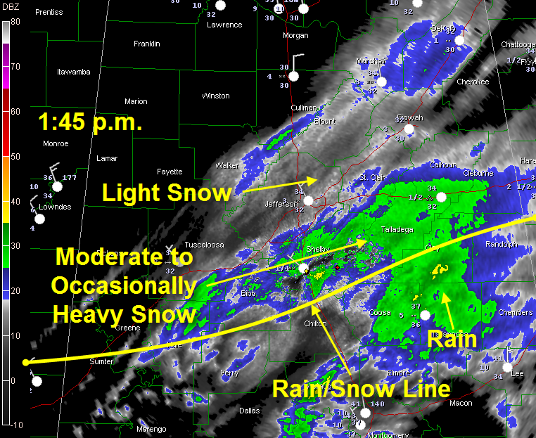
Moderate to occasionally heavy snow continues just south of the I-20 corridor this afternoon, in areas east of Moundville.
Light snow continues back from Tuscaloosa and Walker Counties into Jefferson, Blount and St. Clair Counties. Some moderate snow is over Northeast Alabama over Marshall, DeKalb and Cherokee Counties. The snow has mostly stopped here in Trussville.
Some enhanced snowfall was over Blount County, from Cleveland to Hayden.
The rain/snow line extends from Eutaw to Clanton to Roanoke. South of that, it is raining. The rain/snow line has slowed its southward progress as the low moves south of the Gulf Coast to the south of Fort Walton. As the low continues east, the transport of cold air from the north will increase, pushing the rain/snow line back to the south.
The precipitation will continue to diminish through the afternoon hours as the low moves east.
Meanwhile, snow showers now to our northwest will rotate into North and Central Alabama this evening in association with a a cold upper trough. Additional significant accumulations are not expected, but some sopts could pick up another 1/2 inch of snow from any heavier showers. This could accumulate on roadways, especially bridges and overpasses with temperatures in the 20s.
Also, any snow or moisture left on roadways could freeze into icy patches this evening. Be careful if you will be traveling this afternoon or tonight. Lows tonight will drop into the lower and middle 20s.



