


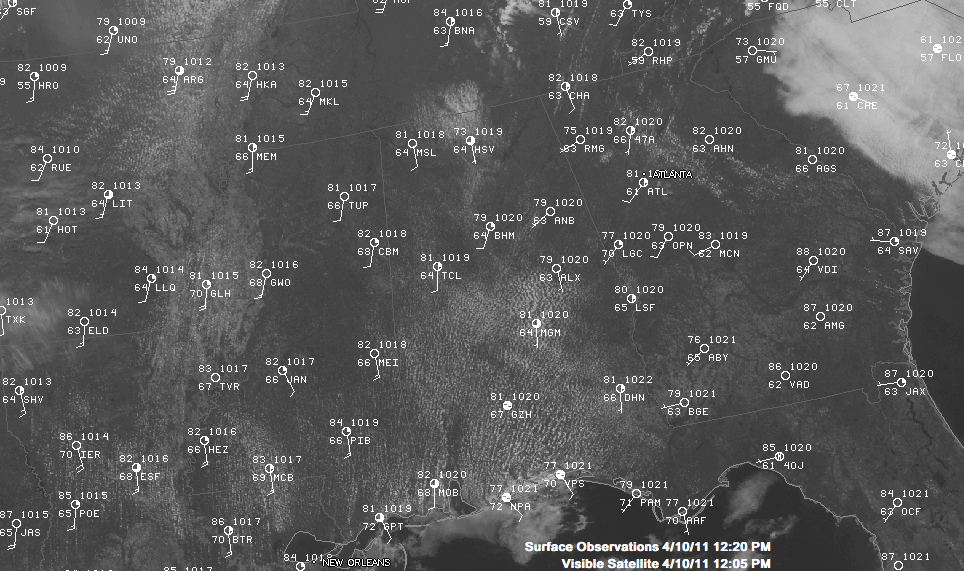
80F AT 1 PM IN BIRMINGHAM: It was 80F in Birmingham at 1 p.m., some five degrees behind the same time yesterday. But sunshine is out in full force now and the mercury will soar. More high temperature records may fall this afternoon across Alabama as our early preview of summer continues for one more today. Showers and storms are on the menu for tomorrow, and some of them could be severe. We will enjoy two fine days Tuesday and Wednesday, with cooler temperatures and lower humidities followed by a transition back to rain and storms for late Thursday and Friday followed by fair and cooler conditions for race weekend.
WIDE RANGE IN READINGS: There was a wide range in temperatures across Central Alabama this morning. It was 57F at Pinson and 67F just a few miles away at the Birmingham airport. Anniston dropped to 58F, while it was 68F at Tuscaloosa. Calera registered 64F for their morning low.
ACROSS ALABAMA AT NOON: Persistent low clouds formed again overnight as a moist atmosphere cooled even as moisture laden air continued to flow in from the Gulf of Mexico. The low clouds began to break up by 10 a.m. and this process will continue as sunshine increases and drier air aloft mixes down. This will allow the mercury to take off, and we expect readings that are running 3-4 degrees behind yesterday to quickly catch up. Readings will top out in the middle to upper 80s. Since we are getting a late start because of the clouds, it might be a little hard to tie or break the record high at Birmingham, which is 88F.
NO RAIN NEARBY: The nearest precipitation to Alabama is some light showers over northern Ohio. Thunderstorms are rapidly developing over southern Wisconsin. The Badger State will be ground zero for severe weather today as a capping inversion over an increasingly unstable airmass exploded later this afternoon. Strong upper level winds will allow for big supercells to form and lowlevel shear that is off the charts will result in strong tornadoes. It could be a long afternoon and night in the upper Midwest. Here, we will be mild and humid overnight with lows in the 60s and a light southerly breeze all night.
SEVERE WEATHER TOMORROW: The rapidly intensifying surface low at the heart of the Midwestern severe weather outbreak is centered near St. Cloud MN this afternoon with a central pressure of 992 millibars. By this evening, the pressure will drop to around 982 millibars, about the equivalent of a category one hurricane. It will get even stronger as it migrates into Canada, being forecast to drop to about 977 millibars by tomorrow morning. Luckily for us, that low is way far to the north of Alabama.
The trailing cold front will move into Arkansas overnight. As it pushes towards the southeast, strong storms will pound the Magnolia State and push into northwestern Mississippi during the morning. Meanwhile, the atmosphere over Alabama will be slowly growing unstable as temperatures warm the moist atmosphere. We expect CAPEs to rise to between 750-1500 joules/kg over Central Alabama ahead of the front. That is moderately unstable. Wind profiles will be unidirectional (generally the same direction as you go up in altitude). This tends to result in a line of intense thunderstorms.
The main threats look to be damaging winds and hail, but we will be watching two things that could increase the threat of tornadoes: discrete storms that develop ahead of the line and the potential that another surface low could develop along the southeastward moving front, increasing low level wind shear. In any case, be alert for severe weather on Monday and stay close to a source of reliable weather information. And don’t forget the number one Alabama weather maxim: when it comes to thunderstorms, expect the unexpected.
BREEZY TOMORROW: One thing you will notice tomorrow will be a breezy southerly wind, averaging some 12-25 mph with higher gusts.
COOLER/DRIER FOR TUESDAY: Cooler and drier air will flow into Alabama behind the cold front, which should reach the I-59 corridor by 4 p.m. Monday. Lows by Tuesday morning will make the upper 40s over portions of the area. Skies will clear quickly on Tuesday with highs topping out near 70 degrees. There will also be a persistent northerly breeze averaging 10 mph.



