


So, we have a high risk on the board for North and North Central Alabama for today.
And round one of today’s activity will be knocking on the door of West Alabama shortly…
Intense thunderstorms are now 80-90 miles west of Sumter, Pickens and southern Lamar Counties in West Alabama.
They are moving east northeast at 45 mph. Do the math, and you see that they will be approaching these counties between 3 and 4 a.m.
There are at least two tornado vortex signatures right now in these storms on the Jackson Doppler radar and a slew of warnings ahead of them, including two tornado warnings.
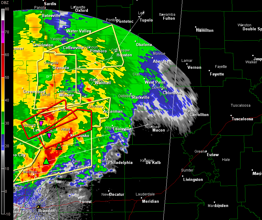
They have weakened some in the past hour, and by all expectations, they should continue to weaken. But they do have unstable air in front of them still, with CAPEs of 1000+ j/kg over the counties mentioned.
The SPC thinks they will continue and is already contemplating a tornado watch for Alabama…
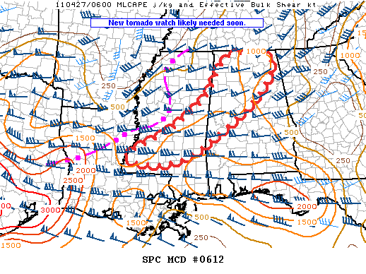
MESOSCALE DISCUSSION 0612
NWS STORM PREDICTION CENTER NORMAN OK
0156 AM CDT WED APR 27 2011
AREAS AFFECTED…SRN MS THROUGH WCNTRL AND NRN AL
CONCERNING…SEVERE POTENTIAL…TORNADO WATCH LIKELY
VALID 270656Z – 270800Z
SEVERE THREAT EXPECTED TO SPREAD THROUGH SRN MS…CNTRL AND NRN AL
DURING THE EARLY MORNING. DAMAGING WIND AND ISOLATED TORNADOES WILL
BE THE MAIN THREATS. A NEW TORNADO WATCH WILL LIKELY BE NEEDED SOON.
EXTENSIVE SQUALL LINE FROM MIDDLE TN SWWD THROUGH NRN AND CNTRL MS
INTO NRN LA IS MOVING EAST AT 40-50 KT. EMBEDDED SUPERCELL AND
BOWING SEGMENTS CONTINUE TO BE OBSERVED. THE ATMOSPHERE EAST OF THE
LINE REMAINS MODERATELY UNSTABLE WITH 1000-1500 J/KG MUCAPE. A
STRONG 60-70 KT LLJ WILL PERSIST ACROSS THE LOWER MS AND TN VALLEY
DURING THE MORNING WITH VERY LARGE 0-2 KM HODOGRAPHS SUPPORTIVE OF
LOW LEVEL MESOCYCLONES AND EMBEDDED QLCS TORNADOES IN ADDITION TO
DAMAGING WIND.
..DIAL.. 04/27/2011
So, look for a new tornado watch shortly, and severe thunderstorm and potentially tornado warnings for West Alabama counties from Sumter through Pickens, Lamar and Marion Counties within the next hour to 90 minutes.
WHAT IMPACT WILL THESE STORMS HAVE ON THE ATMOSPHERE LATER TODAY?
We just don’t know. As Dr. Tim said in a message to me before going to bed at 2, paraphrasing: If the storms come on through early in the morning, the atmosphere will have time to recharge to the impressive indices the models have been touting.
And they may pull up and stop, like the early morning storms did on April 15th. If that happens, there is no question that the airmass south of the storms will still be prime for severe weather, even more so than it was that day.
All we can do now is batten down the hatches in West Alabama for these first storms and then wait and see what the day brings. It’s going to be an interesting day. Let’s hope it’s not a memorable one.



