


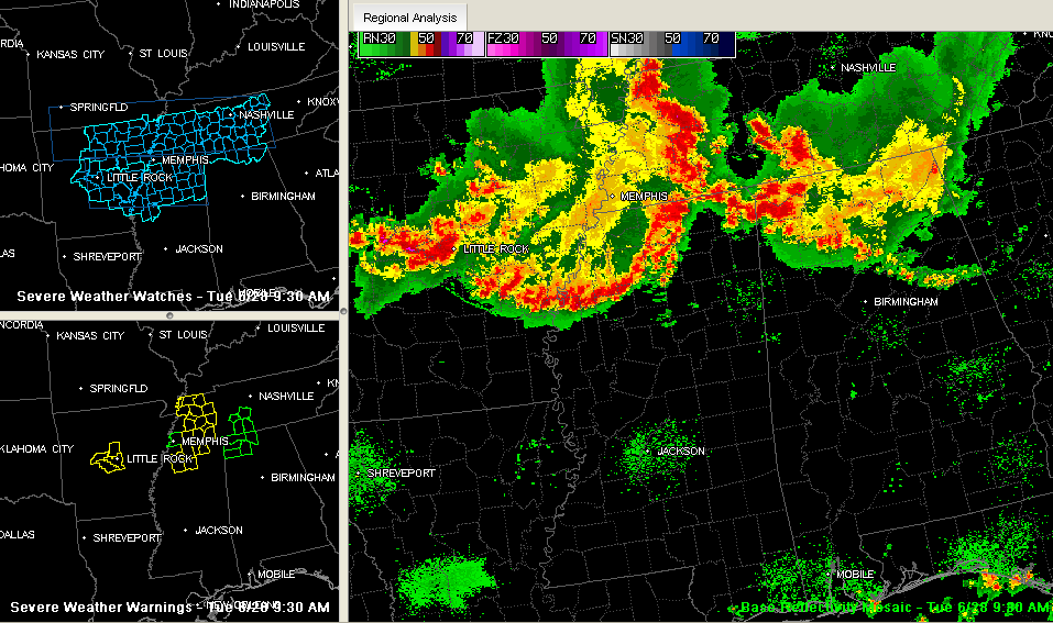
At least two waves of thunderstorms are in store for Alabama today.
The first is dropping southward across North and Northeast Alabama right now. It extends along a northwest to southeast line from Russellville in Franklin County to south of Moulton in Lawrence County to Addison in Winston County. From there it becomes more broken, extending to near Good Hope in Cullman County to north of Cleveland and Oneonta in Blount County to Ashville and Ragland in St. Clair County to Oxford in Calhoun County.
A larger area of rain and storms covers almost all of the Tennessee Valley from I-65 eastward into Jackson and DeKalb Counties. Some heavy rain was falling here.
When these storms were stronger a little earlier, they resulted in wind damage over Northeast Alabama including a tree down near Sylvania and a tree down on a house near Fort Payne…all in DeKalb County. Vic Bell in Black Creek observed 30 mph winds with the outflow.
But the strongest storms in Alabama are definitely the strongest but they have weakened a tad. There were severe thunderstorm warnings earlier for Colbert, Franklin and Lawrence Counties but they have expired.
Flash flood warnings are in effect for Colbert, Lauderdale, Lawrence, and Franklin Counties. There have probably been some three inch rainfall amounts up there. In addition, winds gusted to 55 mph near Muscle Shoals and 54 mph near Florence around 820-825 a.m. Colbert County reports numerous trees down and power outages across the county.
It will be interesting to see how far south this line makes it. It could run out of steam somewhere south of the I-22/I-20 corridor. It will act as a boundary today, with more stable, rain cooled air to the north and more unstable air to the south.
Then, looking up the tracks, a complex of strong storms has passed Memphis and is pushing southeastward through northwestern Mississippi. This complex is prompting several severe thunderstorm warnings from the Kentucky/Tennessee border to Jackson TN all the way to north of Oxford MS. It has produced numerous reports of wind damage across eastern Arkansas, western Tennessee and now Northwest Mississippi. These storms are associated with a mesoscale convective vortex (MCV)that is pushing into western Tennessee northwest of Jackson. These systems can hold together over long distances and pack quite a punch with wind damage.
Severe thunderstorm watches are in effect for for much of Tennessee, the Tennessee valley of North Alabama, eastern Arkansas and northwestern Mississippi.
It will be a complex forecast today as we watch the strong MCV and its storms interact with the first complex and the boundary that it is laying down across North Central and East Alabama.
In addition, other storms will form along any boundaries created this morning and those could be strong.
Storms will produce torrential rains, deadly lightning, some hail and the potential for damaging winds, especially in the big storm complexes.
Stay alert, watch the sky and radar, and be in a safe place when the strong storms approach your location. Be aware if you will be driving anywhere today and plan your trips to avoid the heaviest storms if possible.
For now….here is what you can expect…
NORTHWEST ALABAMA….rain and heavy thunderstorms north of the line as it sinks slowly south and stalls.
NORTHEAST/EAST ALABAMA…gusty winds with the line of showers moving south through Cullman, northern Jefferson, Bount, St. Clair, Talladega, Calhoun and into Clay and Randolph Counties. Moderate to heavy rain over Northeast Alabama from Huntsville to Scottsboro and Fort Payne. The NWS Huntsville has just issued a flash flood watch for their North Alabama Counties indluding Cullman until 10 p.m. tonight.
FOR THE REST OF CENTRAL ALABAMA…clouds down to I-22 and I-20, with increasing sunshine southwest of that line. Temperatures will warm well into the 90s southwest of the line, peak in the lower or middle 80s near I-22/20 and stay in the 70s over North Alabama. The big complex of storms will continue southeast. If it holds together, it will bring strong to severe storms to a wide area this afternoon southwest of a line from Marion County to Birmingham/Tuscaloosa and points southeast.



