


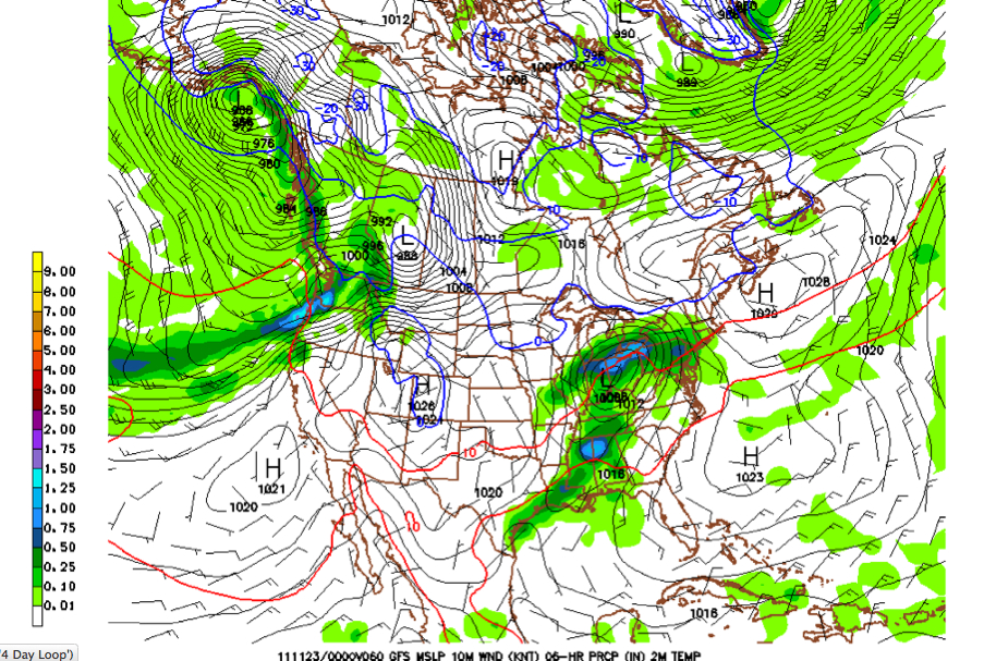
GFS Surface Setup for 6 p.m. CST Tuesday - Click to Enlarge Image
Tuesday seems to be shaping up as a potential severe weather day for Alabama as a strong upper trough and surface low impact the region.
By Tuesday morning, the surface low will be in Central Illinois with a trailing cold front west of the Mississippi River. Showers and storms will be spreading across Mississippi and will reach western Alabama during the afternoon.
Temperatures will be in the 70s ahead of the front, with dewpoints in the middle 60s. Instabilities will be between 750-1,000 j/kg. There will be a decent low level jet at 5,000 feet and bulk wind shear will be sufficient for sustained updrafts. There will also be divergence at the Jetstream level, which is another factor for severe storm development.
So, several ingredients will be in place for a significant severe weather outbreak across Alabama Tuesday afternoon and evening, including the potential for supercell thunderstorms.
The threat will mainly affect areas west of I-65 between noon and 6 p.m., shifting eastward as the afternoon and evening progress. It is a situation that will have to be monitored closely.
Needless to say, all Alabamians should carefully monitor this developing weather situation.
STACK THE ODDS IN YOUR FAVOR:
1. Have a method for receiving tornado warnings, whether it is NOAA Weatheradio, an app, social media, email or the television. In fact, have more than one method, because as April 27th proved, systems fail at critical moments.
2. Know what to do when severe weather threatens. Underground, under something sturdy is the best rule. But know what you will do when that moment comes and a tornado warning is issued for you. Here is a complete list of safety suggestions, broken down into actions during severe weather threat days and during tornado, severe thunderstorm and flash flood watches and warnings. Please use it to help formulate your family’s personal severe weather plan.
IF you have a warnings source and know what to do to get to a place of absolute safety, you are nearly 100% certain to be uninjured by a tornado. Stack the odds in your favor…it’s easy to do.
HAVING SAID ALL THIS…THIS EVENT IS NOT APRIL 27th
The April 27th tornado outbreak hopefully is a once in a lifetime event, but it doesn’t take a historic outbreak to produce tornadoes and severe thunderstorms that can injure and kill people. We need to treat all potential severe weather events as life threatening. This means knowing your plan and executing it when warnings are issued. Then you don’t have to worry!



