


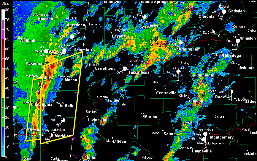
An intensifying line of thunderstorms is pushing through eastern Mississippi at this hour. It is approaching Noxubee, Kemper and Lauderdale Counties in eastern Mississippi.
Severe thunderstorm warnings have been in effect for Winston, Neshoba and Newton Counties. A new warning for just issued for parts of Kemper, Lauderdale, Noxubee, Winston and Lowndes Counties.
These storms will affect Lamar, Pickens, Sumter and Greene Counties within the next 75 minutes…by 2:15 p.m.
Severe thunderstorm warnings will be issued for parts of these western Alabama counties soon.
The main impact with this line will be damaging winds. They could occur across a wide area.
It would be advisable to be out of mobile homes before these storms arrive, don’t be driving during them and if you are in a site built home, be away from outside walls and windows. There have been multiple reports of trees down as this line has moved east northeastward.
Thunderstorms are strengthening across Tuscaloosa, western Jefferson and southeastern Walker Counties as well at this hour but they are not severe at this time. There is lots of lightning with this storm activity though. It will affect much of the Birmingham metro area over the next 90 minutes.
Other storms have formed over Blount County. They will push northeastward into Northeast Alabama, where conditions are not as favorable for severe weather.
Storms that form ahead of the main line do pose a threat to become severe with damaging winds. There could even be a couple of isolated tornadoes this afternoon, so stay close to a reliable source of weather information. A tornado watch remains in effect for much of West Central Alabama until 5 p.m. CST.



