


The SPC has had a slight risk outlook out for tomorrow since yesterday, so they have pretty good confidence that severe weather will be a problem on Sunday.
On their late morning update to the Day 2 outlook, they have increased the severe probabilities to 30% over areas northwest of I-59 for tomorrow night.
Here is the day two probabilities of severe weather within 25 miles of any point.
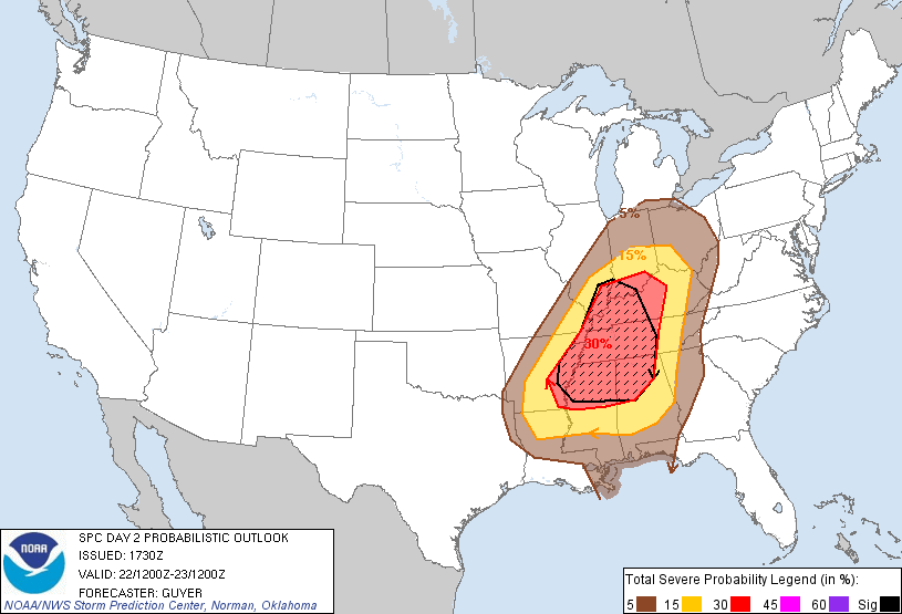
The hatched area is where the SPC forecaster thinks there is a 10% probability of significant severe weather during the period (F2 or greater tornado, 75 mph or greater winds or 2 inch or greater hail).
A stronger upper level system will rotate into place west of Alabama Sunday night. This will provide colder air aloft to enhance instabilities and extra lift to spark storm formation. The result will be increasing showers and thunderstorms Sunday night. The good news is that we couldn’t pick a better time of day for the storms to come in, at least from a heating and instability standpoint. Instabilities are predicted to be between 500-750 joules tomorrow night across Alabama, which is not very high.
But the wind fields look especially strong with 100 knot winds at 18,000 feet and 60 knot winds at 5,000 feet. These especially strong wind fields could overcome the low instability and produce a more significant severe weather event.
So concern is there that we could deal with a tornado event to our west late in the day, perhaps working into North and West Central Alabama during the night before it transitions to a damaging wind event during the early morning hours. The threat seems to be a little more significant and we will need to monitor it carefully.
Needless to say, all Alabamians will want to monitor the latest forecasts later today and tonight and on Sunday as we adjust our forecasts for this developing weather situation.



