


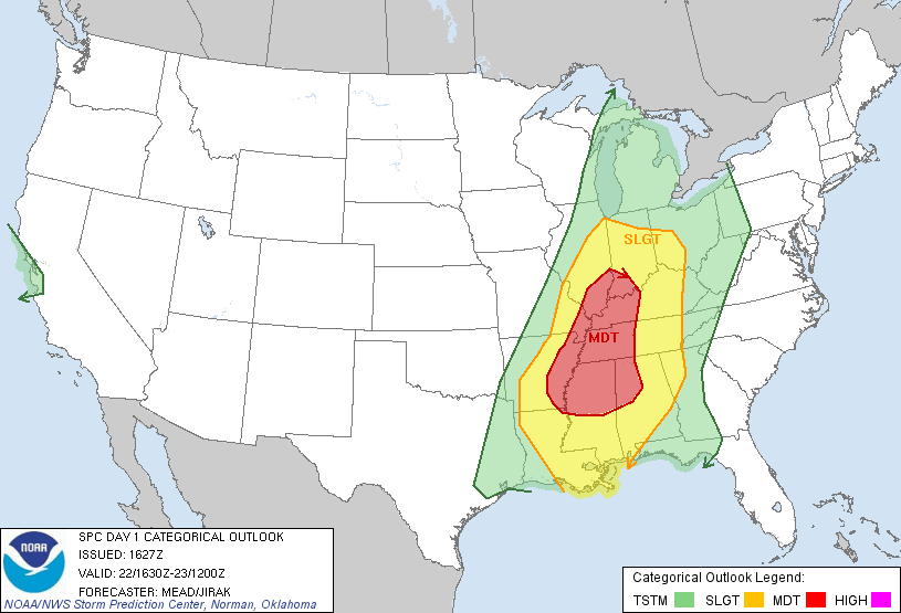
The Storm Prediction center has issued its 1030 a.m. update of the Day One Severe Weather Outlook.
It has expanded the moderate risk categorical outlook northward into Illinois and Indiana. It now extends nearly as far north as St. Louis and Indianapolis.
All this is due to a very strong upper level trough over the Plains that is expected to rotate east and northeast over the next 24 hours. It is accompanied by fast upper level winds. At 30,000 feet, jetstream winds are roaring at over 150 mph back over the Southwest into the Texas Panhandle. At 18,000 feet, winds are racing at over 100 mph through the base of the trough over New Mexico.
At the surface, a low is intensifying over western Kansas. This low will move northeastward to northern Illinois late tonight.
A tremendous amount of rich, moist air is over the Gulf of Mexico, extending into southern Louisiana, Mississippi, Alabamaa and Northwest Florida. Dewpoints along the coast include 67F at Pensacola, 69F at Panama City and 70F at New Orleans and Baton Rouge. It is already starting to come north behind a retreating warm front that is over southern Alabama and Mississippi. Dewpoints have risen in the past 6 hours from 46F to 55 F at Tuscaloosa, from 48F to 55F at Birmingham, from 48F to 57F at Meridian and 57F to 63F at Jackson. Dewpoints across Central Alabama will rise into the lower 60s tonight. Afternoon temperatures will rise into the upper 60s with a few spots getting into the lower 70s, especially if the sun comes out.
The sun is nowhere in sight right now, but looking at visible satellite imagery, you can see clouds beginning to thin a bit, especially over South Central Alabama.
The first radar echoes are showing up on radar near Atmore AL and north of Panama City. These are lifting northward with the warm front. This warm frontal boundary could be the focus for severe weather this afternoon as it lifts into Central Alabama. It should be near US-78/280 by late afternoon. Such boundaries are often capable of spinning up tornadoes, so it will have to be watched.
After the warm front passes, we will find ourselves in the warm sector of the cyclone. Instabilities will increase during the evening hours with 500-1000 j/kg of CAPE available over Central Alabama. That’s not very high. But as those 100 mph winds at 18,000 move into Northwest Alabama late tonight, and if our surface winds back a little to the southeast, the profiles could support significant tornadoes mainly in areas along and west of I-65 and along and north of I-59/20.
A powerful line of storms will form over Arkansas this afternoon and start sweeping eastward. It will have strong potential of producing widespread damaging winds tonight. There could also be significant tornadoes embedded in the line. Large hail will also be a threat. In addition, ahead of the main line, any individual storms that form have a higher potential of producing tornadoes as well. We will have to watch for this after the warm front passes and before the main squall line arrives after midnight tonight.
So, starting this afternoon, get ready for watches and warnings. It will be a long event, with the storms not moving out of the state into Georgia until after daybreak tomorrow. Having storms at night is the worst time from a personal planning standpoint, but hopefully it means a little less instability available for the storms.
We don’t even think this will be anything like April 27th, but it could be a significant severe weather outbreak with the potential for strong tornadoes. So we want everyone paying close attention to the weather through the day today and overnight tonight with reliable resources that can get severe weather warnings to you immediately.
Think about your safety plan and plan where you would go if warnings are issued for your specific location wherever you will be today and tonight. If you haven’t got a safety plan, now would be the time to think about that. I will post some specific safety advices shortly for you to review.
Don’t let the situation alarm you. Be armed with information and a plan and hopefully the system will pass with little impact. But if it doesn’t, you will be ready!



