


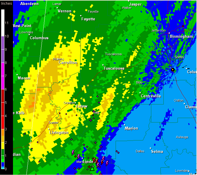
The rain is really coming down over West central Alabama this morning.
At this hour, it is pouring over a wide area from Jefferson through Tuscaloosa and Pickens Counties southward through Bibb, Hale, Greene, Sumter, Marengo and Perry Counties. Areal flood alerts are in effect for these areas.
Doppler radar estimates that over 1.5 inches of rain has fallen across a wide area of Pickens, Greene, Sumter and Hale Counties with over 2 inches from Carrollton to Livingston. Another band of heavy rainfall has been measured from Duncanville to Greensboro across Hale County, with some two inch amounts likely.
Skywatcher Ron Hughes in Coker reports 1.55 inches of rain as of 11 a.m. and still raining heavily.
A tornado watch remains in effect for much of the area southwest, south and east of Birmingham until 5 p.m. Storms were intensifying in areas south of I-59 over West Alabama. Instability is low, but wind fields are increasing a the surface low south of Memphis deepens. There appears to be an upper level disturbance over Marengo County near Linden. It will lift northeast at 30 mph, passing just south of Birmingham around 1:30. This disturbance could trigger some stronger storms as well in areas south of I-59.
So, for Central Alabama counties in the watch area, the threat is currently low, but for areas south of I-59, it will increase over the next couple of hours. There is an outside chance of a tornado in the watch area this afternoon. Damaging winds are also possible.



