


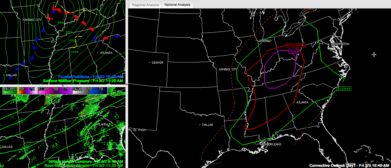
Click image to enlarge
We have already experienced round one of severe weather from this outbreak. More severe weather will develop this afternoon. Please make sure you have a plan for any places that you will be this afternoon and tonight in case a tornado warning is issued. Be sure that you have multiple sources for receiving weather warnings.
In the Tennessee Valley, upwards of 50,000 people are without power. This is bad news given that there is more severe weather ahead this afternoon and tonight.
SOME REPORTS FROM EARLIER
10:03: Huntsville Police reported rain wrapped tornado at Bob Wade/Nick Fitchard.
A tornado emergency was issued by the NWS Huntsville at 10:06 in a tornado warning follow up.
10:07: Wall Triana and Nick Davis looking NE past Capshaw Mountain – spotter reports large rotating wall cloud with defined funnel. Two minutes later, that funnel was reported descending.
10:10: Tornado on the ground…Moores Mill and Lincoln Road.
10:12: Wedge tornado likely moving through northern Madison county right now! CC values on KHTX indicative of very large debris.
The dual pol radar from Hytop and the ARMOR radar gave several excellent indications of debris.
10:15: Tornado on ground headed directly towards Buckhorn HS (New Market community). Damage was reported at Buckhorn HS. No injuries.
10:16: Confirmed tornado crossing Winchester Road at this time. Cross street Maysville Road.
10:18: From NWS HUN…getting reports of significant/major structural damage in northern Madison county. Note: preliminary reports at this time
Circulation has weakened on last two volume scans as cell approached Jackson county. Still some indications of debris on CC.
Tornado continued into southern Franklin County in Tennessee.
MORE REPORTS FROM NWS HUNTSVILLE
HUN: Fayetteville [Lincoln Co, TN] emergency mngr reports HAIL of pea size (E0.25 INCH) at 09:10 AM CST —
HUN: 2 S Athens [Limestone Co, AL] trained spotter reports FUNNEL CLOUD at 09:40 AM CST —
HUN: 5 S Hazel Green [Madison Co, AL] trained spotter reports TORNADO at 09:43 AM CST — 50 mph winds with power lines sparking…rotation reported. tornado reported on ground
HUN: 3 N Meridianville [Madison Co, AL] law enforcement reports TORNADO at 09:47 AM CST — power lines down on car
HUN: 6 Nw Huntsville [Madison Co, AL] amateur radio reports TORNADO at 09:49 AM CST — research park blvd and dan tibbs…funnel cloud
HUN: Ardmore [Limestone Co, AL] trained spotter reports HAIL of golf ball size (E1.75 INCH) at 09:58 AM CST —
HUN: 5 Wsw Meridianville [Madison Co, AL] law enforcement reports TORNADO at 10:01 AM CST — rain wrap tornado
HUN: Meridianville [Madison Co, AL] emergency mngr reports HAIL of golf ball size (E1.75 INCH) at 10:05 AM CST —
HUN: 1 E Meridianville [Madison Co, AL] public reports TORNADO at 10:07 AM CST — rain wrap tornado
HUN: 3 E Meridianville [Madison Co, AL] law enforcement reports TORNADO at 10:08 AM CST — tornado on ground
HUN: 4 Ene Moores Mill [Madison Co, AL] trained spotter reports TORNADO at 10:15 AM CST — tornado on ground
HUN: 5 Ne Meridianville [Madison Co, AL] emergency mngr reports TORNADO at 10:19 AM CST — house destroyed
HUN: 4 Ene Moores Mill [Madison Co, AL] emergency mngr reports TORNADO at 10:19 AM CST — people trapped in rubble with injuries
HUN: 4 Ene Moores Mill [Madison Co, AL] amateur radio reports TORNADO at 10:32 AM CST — trees down…cars damaged and farm house destroyed near buckhorn high school
HUN: 5 Nne Moores Mill [Madison Co, AL] trained spotter reports TORNADO at 10:43 AM CST — powerlines down at beth and butler roads
HUN: 3 E Meridianville [Madison Co, AL] trained spotter reports TORNADO at 10:54 AM CST — power lines down on roads and damage to farm building
There is a Twitter report of injuries at the Limestone Correction Facility.
Meridianville Middle School was hit by the tornado. The damage was not extensive and there are no injuries.
A number of schools have early dismissal today. Check for the latest regarding your students.
This is just round one. The atmosphere continues to heat up and become more unstable. Don’t let sunshine fool you. Sun provides heating that makes the atmosphere more volatile.
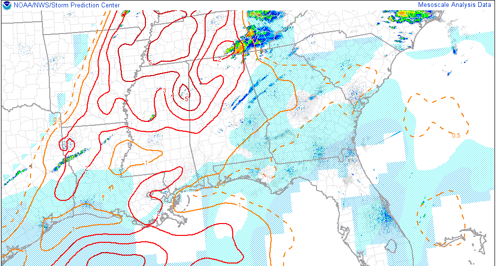
Look at the significant tornado parameter near Columbus MS. It is all the way up to 5 now. Anything above a 1 is indicative of the possibility of significant (EF2 or greater tornadoes). You can see that areas generally northwest of I-59 in Central and North Alabama are at or above 2.
The SPC maintains an enhanced risk of severe weather generally north of a line from York to Verbena to Roanoke. There is a slight risk south of there. There is a high risk over Kentucky, Tennessee, Indiana and Ohio. There is a PDS Tornado Watch for southeastern Missouri into Illinois, Indiana and western Kentucky.
A tornado is passing just north of Chattanooga.
Showers and storms are expected to fire over eastern Mississippi and northwestern Alabama in the next couple of hours. These storms will rapidly become severe. They will be capable of producing tornadoes, damaging winds and severe hail. This activity will develop southeastward through the afternoon hours, affecting the rest of Central Alabama with time. Eventually a long line of intense storms will sweep through the area overnight ahead of a cold front.
Be ready. Be safe. Tell others.



