


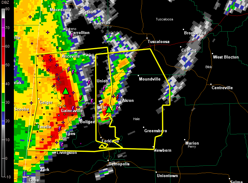
Dangerous bow echo moving across West Central Alabama this morning with high potential for damaging winds.
The high winds will be impacting Union, Eutaw, Forkland imminently. Folks in Moundville, Greensboro and Newbern can expect the high winds around 11 a.m. or sooner. There will be a gust front ahead of the main line, and it will look quite menacing as well and will have some strong winds. It produced strong winds as it passed through Boligee about 10:20.
ADVERTISEMENT
Getting severe weather alerts immediately wherever you are is a critical part of protecting yourself and your family. Bill Murray’s simple new iPhone app MyWARN delivers lifesaving tornado, severe thunderstorm and flash flood watches and warnings to you anywhere, based on your phone’s location based services. Take advantage of a special one time price offer for AlabamaWX.com readers.
THE NATIONAL WEATHER SERVICE IN BIRMINGHAM HAS ISSUED A
* SEVERE THUNDERSTORM WARNING FOR…
EASTERN GREENE COUNTY IN WEST CENTRAL ALABAMA…
HALE COUNTY IN WEST CENTRAL ALABAMA…
SOUTHWESTERN TUSCALOOSA COUNTY IN WEST CENTRAL ALABAMA…
* UNTIL 1130 AM CDT
* AT 1023 AM CDT…THE NATIONAL WEATHER SERVICE INDICATED A LINE OF
SEVERE THUNDERSTORMS CAPABLE OF PRODUCING QUARTER SIZE HAIL…AND
DAMAGING WINDS IN EXCESS OF 60 MPH. THESE STORMS WERE LOCATED
ALONG A LINE EXTENDING FROM ALICEVILLE TO ALLISON TO THE UNIVERSITY
OF WEST ALABAMA…AND MOVING EAST AT 40 MPH.
* LOCATIONS IMPACTED INCLUDE…
EUTAW…GREENSBORO…UNION…WALDEN QUARTERS…WEDGEWORTH…
EVANSVILLE…FORKLAND AND AKRON.
THIS INCLUDES…
INTERSTATE 20 EXIT NUMBERS 45 THROUGH 62…
PRECAUTIONARY/PREPAREDNESS ACTIONS…
FOR YOUR PROTECTION…MOVE TO AN INTERIOR ROOM ON THE LOWEST FLOOR OF
YOUR HOME OR BUSINESS.



