


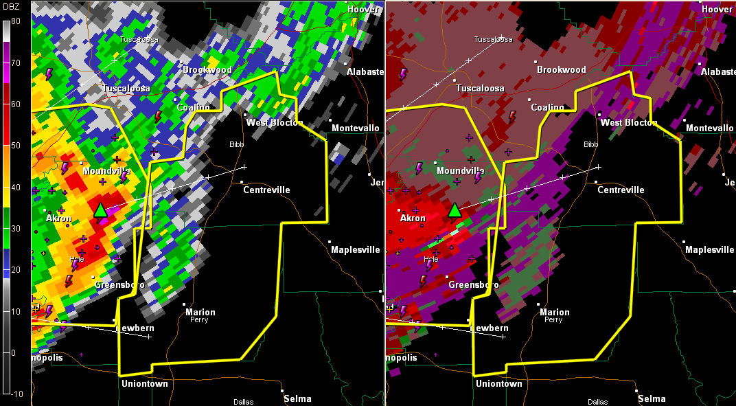
New severe thunderstorm warning for Bibb and Perry.
Tusclaoosa County is now clear from their severe thunderstorm warning.
Severe thunderstorm warning continues for Hale and southeastern Greene Counties until 11:30.
Our bow echo continues pushing east at 30-35 mph late this morning.
The reflectivities have weakened in the past few minutes, which is good. But Doppler Radar continues to indicate high winds just above the surface from Akron to Eutaw to south of Union.
The left image is reflectivity and shows precipitation. The green triangle is a hail indicator. The right side of the image is the Doppler Base Velocity showing winds. As you can see, there are still strong winds just above the surface behind the line of storms.
Very strong winds aloft have been pushing into the line of storms from the back all morning. As the line encounters a little more instability as it heads east over Central Alabama, the potential for more wind and hail will increase. A severe thunderstorm watch remains in effect until 5 p.m. for much of Central Alabama.
The bow appears to be turning into an mesoscale convective vortex that will continue east northeast.
Folks from Greensboro to Moundville up to West Blocton through Centreville down to Marion need to prepare for the potential for high winds. These winds can bring down trees and tree limbs which can damage homes and cars. Unanchored mobile homes could be blown over.
Hail is a threat also. Golf ball sized hail was reported in Havana Junction, the birthplace of America’s Great Weather Legend, J.B. Elliott. Good indication of hail just east of Akron.
ADVERTISEMENT
Getting severe weather alerts immediately wherever you are is a critical part of protecting yourself and your family. Bill Murray’s simple new iPhone app MyWARN delivers lifesaving tornado, severe thunderstorm and flash flood watches and warnings to you anywhere, based on your phone’s location based services. Take advantage of a special one time price offer for AlabamaWX.com readers.
THE NATIONAL WEATHER SERVICE IN BIRMINGHAM HAS ISSUED A
* SEVERE THUNDERSTORM WARNING FOR…
BIBB COUNTY IN ALABAMA…
PERRY COUNTY IN ALABAMA…
* UNTIL NOON CDT
* AT 1105 AM CDT…THE NATIONAL WEATHER SERVICE INDICATED A LINE OF
SEVERE THUNDERSTORMS CAPABLE OF PRODUCING GOLF BALL SIZE HAIL…AND
DAMAGING WINDS IN EXCESS OF 60 MPH. THESE STORMS WERE LOCATED
ALONG A LINE EXTENDING FROM MOUNDVILLE TO MERTZ TO 7 MILES
NORTHEAST OF GREENSBORO TO ARCOLA…AND MOVING EAST AT 45 MPH.
* LOCATIONS IMPACTED INCLUDE…
MARION…BRENT…CENTREVILLE…MERTZ…LOW GAP…HEIBERGER…
HARRISBURG AND EOLINE.
PRECAUTIONARY/PREPAREDNESS ACTIONS…
FOR YOUR PROTECTION…MOVE TO AN INTERIOR ROOM ON THE LOWEST FLOOR OF
YOUR HOME OR BUSINESS.



