


LATE REPORTS:
…Golf ball siexed hail reported in Cordoba at 5:46.
…Quarter sized hail in Poplar Springs in Winston County at 5:37.
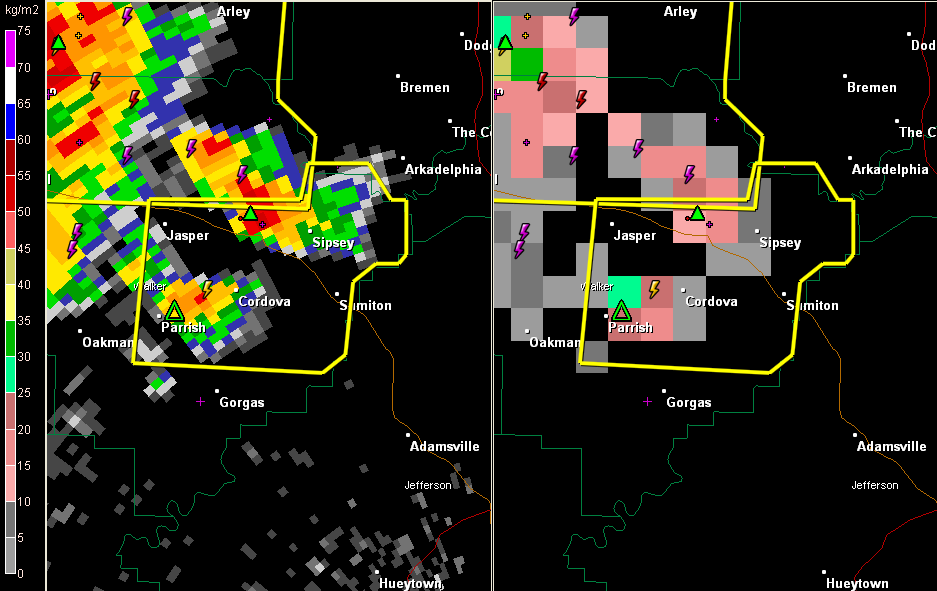
Strong storm near Cordova. It is intensifying quickly and will produce large hail as it moves toward Sipsey.
The storm just northeast of there produced enough hail just east of Jasper to cover the ground. It is moving northeast and is no into southeastern Winston County. It will push into Cullman County shortly.
To the south, a few reports of trees down in Fayette County, including one in the city of Fayette on 14th street NW.
ADVERTISEMENT
Getting severe weather alerts immediately wherever you are is a critical part of protecting yourself and your family. Bill Murray’s simple new iPhone app MyWARN delivers lifesaving tornado, severe thunderstorm and flash flood watches and warnings to you anywhere, based on your phone’s location based services. Take advantage of a special one time price offer for AlabamaWX.com readers.
THE NATIONAL WEATHER SERVICE IN BIRMINGHAM HAS ISSUED A
* SEVERE THUNDERSTORM WARNING FOR…
EAST CENTRAL WALKER COUNTY IN ALABAMA…
* UNTIL 630 PM CDT
* AT 538 PM CDT…THE NATIONAL WEATHER SERVICE INDICATED A SEVERE
THUNDERSTORM CAPABLE OF PRODUCING QUARTER SIZE HAIL…AND DAMAGING
WINDS IN EXCESS OF 60 MPH. THIS STORM WAS LOCATED NEAR CORDOVA…
AND MOVING EAST AT 25 MPH.
* LOCATIONS IMPACTED INCLUDE…
CORDOVA…DORA…SUMITON…BELOIT…LYNNS PARK…BURNWELL…QUINTON
AND ROCKY HOLLOW.
THIS INCLUDES…
US 78 EXIT NUMBERS 63 THROUGH 78…
PRECAUTIONARY/PREPAREDNESS ACTIONS…
IF YOU ARE IN THE PATH OF THIS STORM…PREPARE IMMEDIATELY FOR LARGE
HAIL AND DAMAGING WINDS. PEOPLE OUTSIDE SHOULD MOVE TO A SHELTER…
PREFERABLY INSIDE A STRONG BUILDING AND AWAY FROM WINDOWS.



