An all new edition of the ABC 33/40 Weather Xtreme video is available in the player on the right sidebar of the blog. You can subscribe to the Weather Xtreme video on iTunes by clicking here.
COOL MORNING: No doubt we need to focus our attention on the hot weather around here in coming days, but let’s not forget that actually about 75 percent of the nation had below average temperatures yesterday…
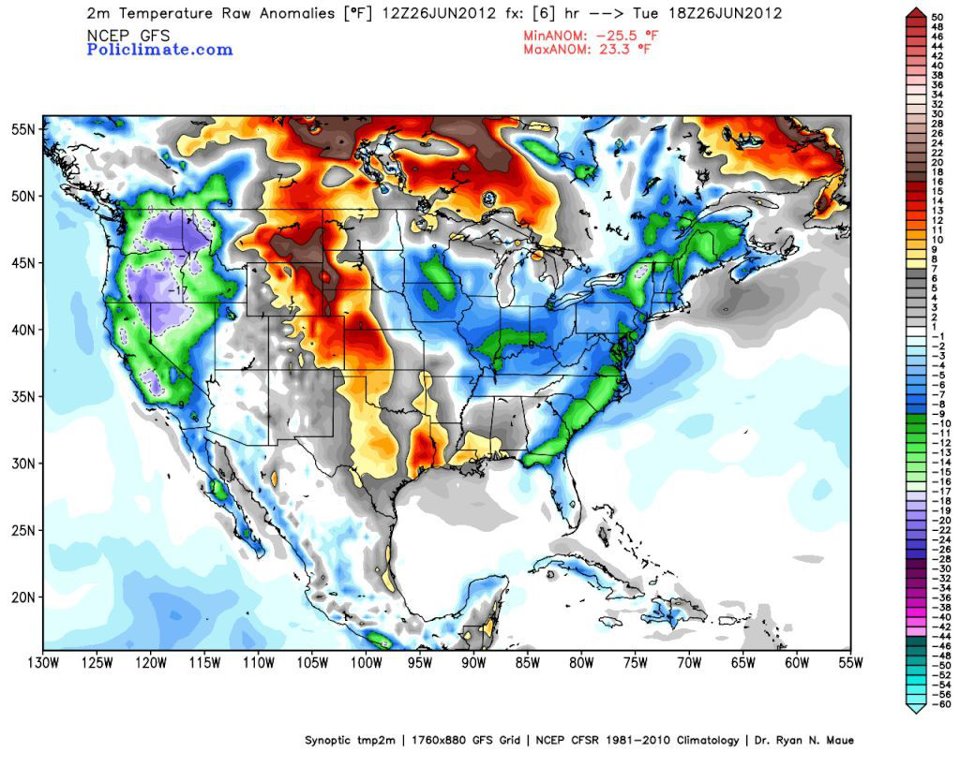
And, some of the that cool/dry air over the Northeast U.S. slipped into Alabama yesterday, and this morning it feels very refreshing. Some morning lows from our Skywatchers…
Black Creek (just northeast of Gadsden) 52
Concord 56
Fayette 57
Coker (west of Tuscaloosa) 57
The air is very dry, and it will heat up quickly again today with most locations seeing mid 90s this afternoon. The humidity will remain very low for a summer day in Alabama.
HEAT PARADE: The big “death ridge” to the west will move our way, and afternoons get very hot from tomorrow through early next week. We project upper 90s tomorrow, and then we deal with highs between 100 and 104 degrees Friday through Sunday. Days will be sunny, nights will be fair, and the chance of a cooling shower is almost nonexistent due to the sinking air motion associated with the upper ridge. If there is any good news it is that the humidity won’t be overly oppressive. Just hot, dry, and dusty.
NEXT WEEK: Big holiday week ahead as we celebrate the middle of summer and Independence Day. We all know it is always hot in Alabama, and with little topsoil moisture temperatures will stay hot next week, but heat levels will fall just a bit as the core of the heat drifts to the north. Looks like highs mostly in the 90s after Monday, and with a little increase in moisture a few widely scattered, pop-up showers or storms might show up by the middle of the week, but not the widespread kind of rain we need.
DEBBY DRIFTING EAST: Tropical Depression Debby is on the Atlantic Coast of Florida this morning south of Daytona Beach… most of the heavy rain is now out to sea, and Debby will move northeast in coming days, well off the East Coast of the U.S. Elsewhere in the Atlantic basin, there is a disturbance between the coast of Africa and the Lesser Antilles, but development is not expected there.
GULF COAST WEATHER: Expect about 8 to 10 hours of sunshine each day along the coast from Panama City to Gulf Shores through the weekend with only a small risk of a shower each day. Highs will be in the 87-90 degree range along the immediate coast, and the sea water temperatures are generally in the low 80s.
WEATHER BRAINS: Don’t forget you can listen to our weekly 90 minute netcast anytime on the web, or on iTunes. This is the show all about weather featuring many familiar voices, including our meteorologists here at ABC 33/40.
CONNECT: You can find me on all of the major social networks…
I will be over at the Talledaga Superspeedway this morning speaking to an Alabama Power function… look for the next Weather Xtreme video here by 3:30 or so this afternoon. Enjoy the day!