


The SPC says there is a good chance that a watch will be required for parts of Alabama soon.
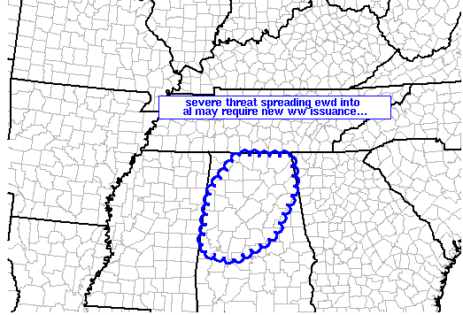
MESOSCALE DISCUSSION 2071
NWS STORM PREDICTION CENTER NORMAN OK
1110 PM CDT WED OCT 17 2012
AREAS AFFECTED…PARTS OF NRN AND CENTRAL AL
CONCERNING…SEVERE POTENTIAL…WATCH POSSIBLE
VALID 180410Z – 180545Z
PROBABILITY OF WATCH ISSUANCE…60 PERCENT
SUMMARY…BAND OF STORMS ADVANCING EWD INTO AL MAY REQUIRE NEW WW
ISSUANCE…
DISCUSSION…LATEST RADAR IMAGERY SHOWS A BAND OF STORMS WITH
EMBEDDED BOWS/LEWPS MARCHING EWD ACROSS NRN MS ATTM. THE DOWNSTREAM
AIRMASS ACROSS AL INCLUDES A MUCH MORE STABLE BOUNDARY
LAYER…SUGGESTING THAT SEVERE POTENTIAL SHOULD SLOWLY DIMINISH WITH
TIME AS STORMS BECOME INCREASINGLY ELEVATED.
STILL…GIVEN THE WELL-ORGANIZED NATURE OF THE LINE — OWING TO THE
VERY DYNAMIC MID-LEVEL SYSTEM…EXPECT SOME THREAT FOR LOCALLY
DAMAGING GUSTS WILL LIKELY PERSIST FOR AT LEAST A COUPLE MORE HOURS.
THUS…NEW WW MAY BE REQUIRED.
YAZOO CITY UNDER THE GUN
In Mississippi, very damaging winds and a possible tornado are impacting the area around Yazoo City. There has certainly had a bad run of luck there over the past few years. From Alan Gerard: Yazoo County reporting “heavy damage” NW of Yazoo City in Lake City and Deerfield Road areas. don’t know any more details than that. Could just be lots of trees, could be structures. Will advise when we know more.
This storm could end up impacting Sumter County a little after 1 a.m.
TORNADO REPORT
2 NE Shelby [Bolivar Co, MS] emergency mngr reports TORNADO at 09:08 PM CDT — heavy damage along blue cane rd…3 structures damaged with one home off its blocks along with the roof removed. power lines down and power poles snapped.
This is for the storm that is near Grenada now.



