


A significant November severe weather outbreak is underway this afternoon across parts of the Midwest with a very dynamic storm system moving across the Great Lakes. There have been numerous reports of severe weather, including large and damaging tornadoes as well as high winds and large hail across that region. Apparently, at least one long track, possibly violent tornado has traveled across Illinois, tracking toward the southern Chicago Metro. Illinois has borne much of the brunt so far, but severe weather will extend across much of the Ohio Valley and into the Deep South into the evening hours.
IMPACT ON ALABAMA: The good news for Alabama is that the main dynamics with this system are well to the north of Alabama and they will stay there. While the impact on our state is not expected to be as great as in states to the north, we still have a threat for severe weather this afternoon, evening and into the overnight.
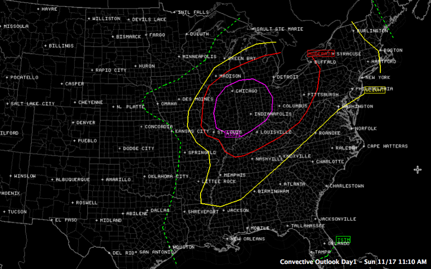
Here is the SPC risk area:
Let’s look at the specifics for our state.
THE ALABAMA WEATHER SITUATION: Clouds have remained thick across the state as warm, moist air has continued to pump into the state. That’s good news. Temperatures are climbing into the lower 70s now in t he I-20 corridor. Dewpoints are rising quickly from the lower 60s to the middle and upper 60s as more moisture moves into West Alabama. The dewpoint at Tuscaloosa had jumped to 67F at noon. There are some breaks in the clouds appearing over Central Mississippi and this should edge into western Alabama as well. There is a good bit of sunshine over eastern Arkansas ahead of the cold front. This sunshine is allowing instabilities to increase over western Mississippi and Arkansas.
Showers and elevated thunder continue over Northeast Alabama, with a band of showers extending southwestward across Marshall, Blount and Walker Counties.
We will be watching as more storms likely develop over Central Mississippi later this afternoon and work into Alabama this evening. Between 5-9 p.m., these storms will try to work into West Alabama. But the good news is that by then, instabilities will be rapidly decreasing and the dynamics will be lifting out to the north with the low. There will be a few potentially strong storms through the evening in the I-20 corridor. By 8-9 p.m., the main line of storms will be pushing into North Alabama. It will sweep southeast through the overnight hours, reaching I-59 around 1-2 a.m. and getting south of the Montgomery area by 7 a.m.
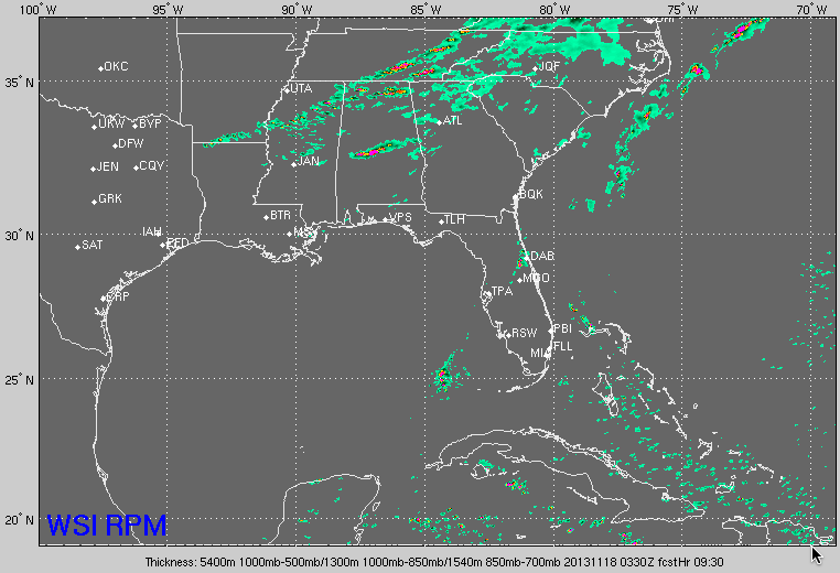
Here is forecast simulated radar from the RPM model at 9:30 p.m. tonight.
STAY ALERT: While the threat of severe weather is NOTHING like what we have seen over the Midwest today, we want all Alabamians in the severe weather risk area to remain alert until the cold front passes during the early morning hours. For Alabama, the greater threat will be damaging hail and damaging winds, with a smaller tornado threat. To be on the safe side, review your severe weather safety plan and have a reliable way to receive watches and warnings.



