


An all new edition of the ABC 33/40 Weather Xtreme video is available in the player on the right sidebar of the blog. You can subscribe to the Weather Xtreme video on iTunes by clicking here.
COMPLEX FORECAST: The pattern is setting up for a complex forecast for Alabama, especially late this week and over the weekend with a shallow layer of cold air will creep in here from the northwest, and a southwest flow aloft continues over the state. But, let’s look at short term weather first…
TONIGHT/TOMORROW: The weather turns warmer. Clouds stick around, and we might see a few widely scattered showers, but much of the day tomorrow will be dry. The high tomorrow will be in the mid to upper 60s.
EVEN WARMER WEDNESDAY/THURSDAY: We project a high between 70 and 74 degrees on these two days, with a mostly cloudy sky. A few scattered showers are possible, but the rain most likely won’t be too heavy or continuous.
TO THE WEST: Brutally cold air invades the western U.S…. many new record lows will be established. The anomalies below are projected Thursday evening from the ECMWF (Euro) model…
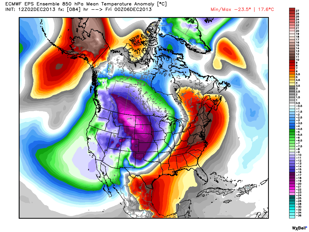
This cold air will only creep into Alabama in very shallow fashion, making for a challenging temperature forecast late in the week.
FRIDAY: I fully expect Florence and Muscle Shoals to stay in the 30s all day Friday, while places like Montgomery and Auburn should reach the 70s. This very tight thermal gradient will make forecasting the high temperature for your neighborhood very difficult. I figure Birmingham will fall into the 40s by afternoon, but just to the south it will be in the 60s. And, as the cold air moves in, rain is likely throughout the day.
To the west, freezing rain and ice accumulations will be an issue for places like Memphis, Little Rock, and Dallas. If you are traveling to these cities west of Alabama Friday, be aware there could be some significant problems due to cold weather and ice.
OUR WEEKEND: We will need to keep the chance of rain going over the weekend, but the rain won’t be continuous, and there should be some good breaks in the rain. Temperatures will remain all over the board; highs over North Alabama Saturday will be in the 40s, and again Muscle Shoals and Florence could hold in the 30s all day. To the south, the high Saturday will be in the 70s.
Showers remain possible Sunday. The ECMWF model shows a rather interesting temperature pattern, with cold Arctic air just to the west, and cold air to the east associated with cold air damming. Much of Alabama is in mild air with potential for temperatures in the 60s. Not sure it works out this way, but it is just an idea…
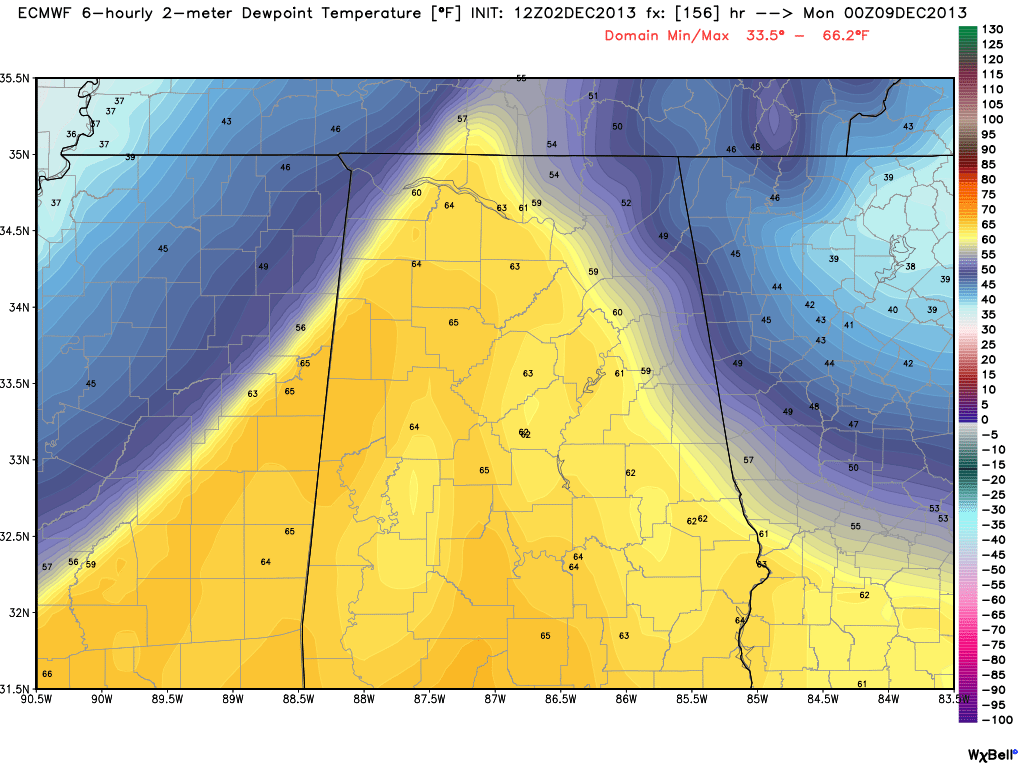
Rain continues at times Sunday night… ending Monday morning. We will still have to watch for some freezing rain Sunday night over Northwest Alabama, but for now we don’t see firm evidence of that happening.
Bottom line is that the forecast for the end of the week and the weekend is very complex, and will change as we get closer. Stay tuned.
WEATHER BRAINS: Don’t forget you can listen to our weekly 90 minute netcast anytime on the web, or on iTunes. This is the show all about weather featuring many familiar voices, including our meteorologists here at ABC 33/40. We will produce this week’s show tonight at 8:30p CT… Roger Edwards of the Storm Prediction Center will be our guest. Watch it live on “James Spann 24/7” on cable systems around the state, or on the web here.
CONNECT: You can find me on all of the major social networks…
Facebook
Twitter
Google Plus
Instagram
Had a great time today visiting with the kids at Elvin Hill Elementary in Columbiana, and Gwin Elementary in Hoover. Be looking for them on the Pepsi KIDCAM today at 5:00 and 6:00 on ABC 33/40 News… the next Weather Xtreme video will be posted here by 7:00 a.m. tomorrow…



