


An all new edition of the ABC 33/40 Weather Xtreme video is available in the player on the right sidebar of the blog. You can subscribe to the Weather Xtreme video on iTunes by clicking here.
WEATHER SMORGASBORD: Over the next seven days, parts of our state will have spring-like warmth, brutal Arctic cold, heavy rain with flooding potential, strong thunderstorms, freezing rain with potential for icy travel, and snow. Most be Alabama. Not everybody will deal with all of these issues, but it is a complex forecast that will require a rather detailed briefing.
Let me suggest you take a few minutes and watch the Weather Xtreme video for the maps, graphics, and details.
TONIGHT/TOMORROW: Not much change. We continue to warm up; we should reach the low 70s tomorrow with a mostly cloudy sky. A few showers or patches of light rain remain possible, but nothing too widespread or heavy.
TO THE WEST: Brutally cold Arctic air will spread down into the Great Plains, setting up an icy mess later in the week for parts of Texas, Oklahoma, Louisiana, Arkansas, West Tennessee, and North Mississippi. Maybe even Northwest Alabama. More on that later.
THURSDAY: The GFS is printing a high of 77 degrees in Birmingham… within two degrees of the record high for December 5, 79 set in 1998. The sky will remain mostly cloudy, but instability values will rise, with surface based CAPE values exceeding 1200 j/kg in spots. This could lead to a few strong thunderstorms Thursday afternoon… there is no formal risk, but SPC does have low end 5 percent severe weather possibilities in place for North Alabama…
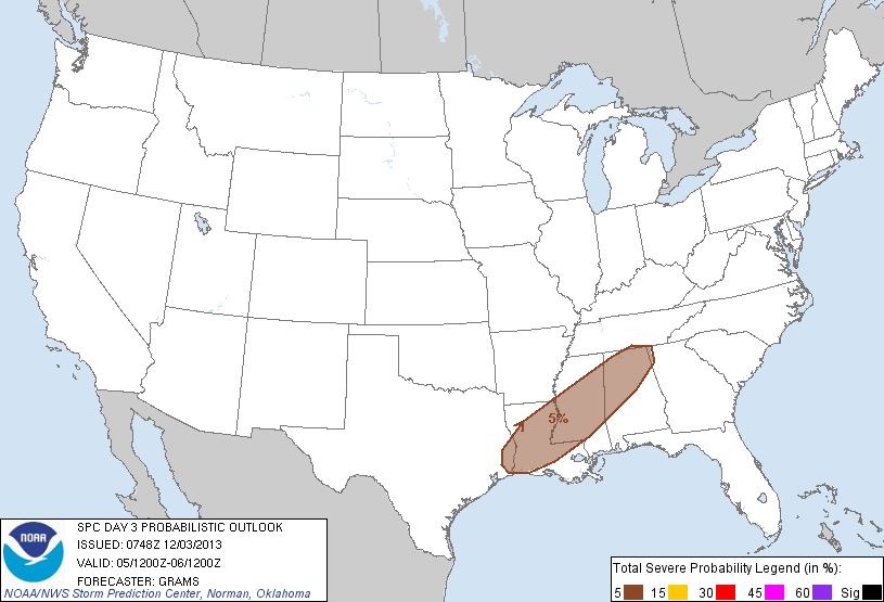
Wind fields are not especially strong, and vertical velocities are not too impressive, so for now the severe weather threat is looking rather minimal. But, we always have to watch it when temperatures rise into the 70s in December, and we must remember this is the core of the fall tornado season in Alabama.
We will forecast a good chance of showers and thunderstorms Thursday afternoon into Thursday night.
FALLING TEMPERATURES FRIDAY: There will be a huge temperature spread across Alabama Friday. During the midday hours, I expect Florence and Muscle Shoals to be in the 30s, while Montgomery is in the 70s. For Birmingham, Tuscaloosa, Anniston, and Gadsden, I figure we start the day in the 60s, with temperatures falling into the 40s during the afternoon as the shallow layer of cold air seeps southward. The sky will be cloudy, and there will be periods of rain as the cold air moves in.
TO THE WEST: Freezing rain and ice will be an issue Friday in cities like Dallas/Fort Worth, Shreveport, Little Rock, and Memphis. If you are traveling to the west, be ready for ice on bridges and overpasses. It could be a real mess in some places.
NORTHWEST ALABAMA ICE FRIDAY NIGHT? I think freezing rain (rain that falls in liquid form when surface temperatures are below 32 degrees) is a real possibility over Lauderdale, Colbert, Limestone, Lawrence, Winston, Marion, and Lamar Counties Friday night. The greatest chance of significant icing and travel problems will come around Florence and Muscle Shoals, but I can’t rule out some icing as far south as Haleyville, Hamilton, and Vernon. Computer models don’t have the resolution to handle the shallow layer of cold air, so I expect guidance to be a little too warm. We will fine tune this call later in the week as the cold air gets closer.
I don’t expect any ice issues now Friday night for Tuscaloosa, Birmingham, Anniston, or Gadsden.
COLD, WET SATURDAY: Rain continues Saturday with a cloudy sky. Temperatures won’t get out of the 40s as the rain falls.
WARMER SUNDAY? Sunday will be another day with temperatures all over the board. Arctic air will slowly retreat, but sometimes it is harder to dislodge that cold air than you might think. A tongue of warmer air will work up into North/Central Alabama Sunday, and temperatures could rise into the 60s thanks to the warm front passing through. But, Northwest Alabama could hold in the 40s, and to the east, some East Alabama communities could hold in the 40s due to cold air damming (the wedge). Whatever the temperature, rain will continue at times through the day and into Sunday night.
BIG TIME COLD NEXT WEEK: The 12Z computer model runs have come in much colder for Tuesday and Wednesday of next week. The GFS suggests the rain could change to light snow before ending Tuesday, with most of North/Central Alabama holding in the 30s all day. Then, by early Wednesday, we drop into the 16-22 degree range with a clearing sky. These numbers will probably have to adjusted later. But plan on very cold weather next week around here.
WEATHER BRAINS: Don’t forget you can listen to our weekly 90 minute netcast anytime on the web, or on iTunes. This is the show all about weather featuring many familiar voices, including our meteorologists here at ABC 33/40. Scroll down for the show notes on the new episode we recorded last night.
CONNECT: You can find me on all of the major social networks…
Facebook
Twitter
Google Plus
Instagram
I had a great time today visiting the 5th graders at Southside Elementary School in Etowah County… be looking for them on the Pepsi KIDCAM today at 5:00 on ABC 33/40 News! The next Weather Xtreme video will be posted here by 7:00 a.m. tomorrow….



