


An all new edition of the ABC 33/40 Weather Xtreme video is available in the player on the right sidebar of the blog. You can subscribe to the Weather Xtreme video on iTunes by clicking here.
HUGE CONTRAST: As forecast here for days, we have experienced a huge temperature swing across Alabama today with a sharp front bisecting the state. At mid-afternoon, there is a 46 degree swing from Haleyville’s 36, to 82 at Montgomery…
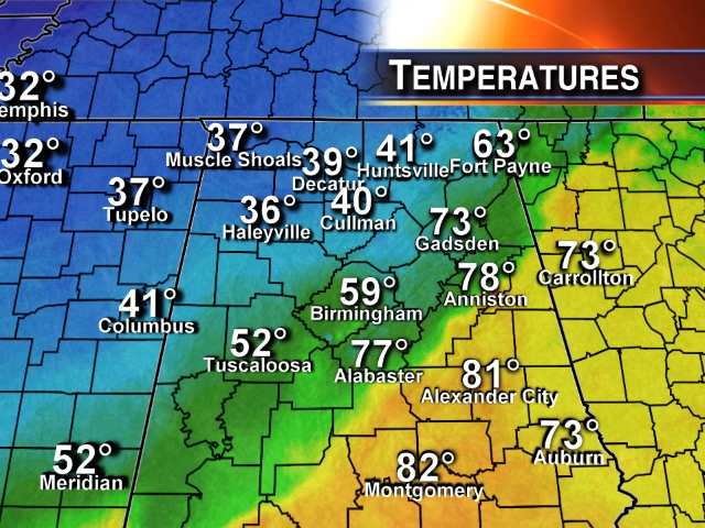
In the cold air over North Alabama, we have areas of dense fog, and lots of rain. In fact, we have thunderstorms in the cold air over Marion and Franklin Counties as I write this.
WET NIGHT: Rain is likely tonight across Alabama, and you might even hear some thunder despite the chill. We will still need to monitor the northwest corner of Alabama, where temperatures will drop below freezing. The bulk of the rain should be over by then, but a few slick spots are possible on bridges where there is standing water. Don’t we have too many issues with icy travel in our state.
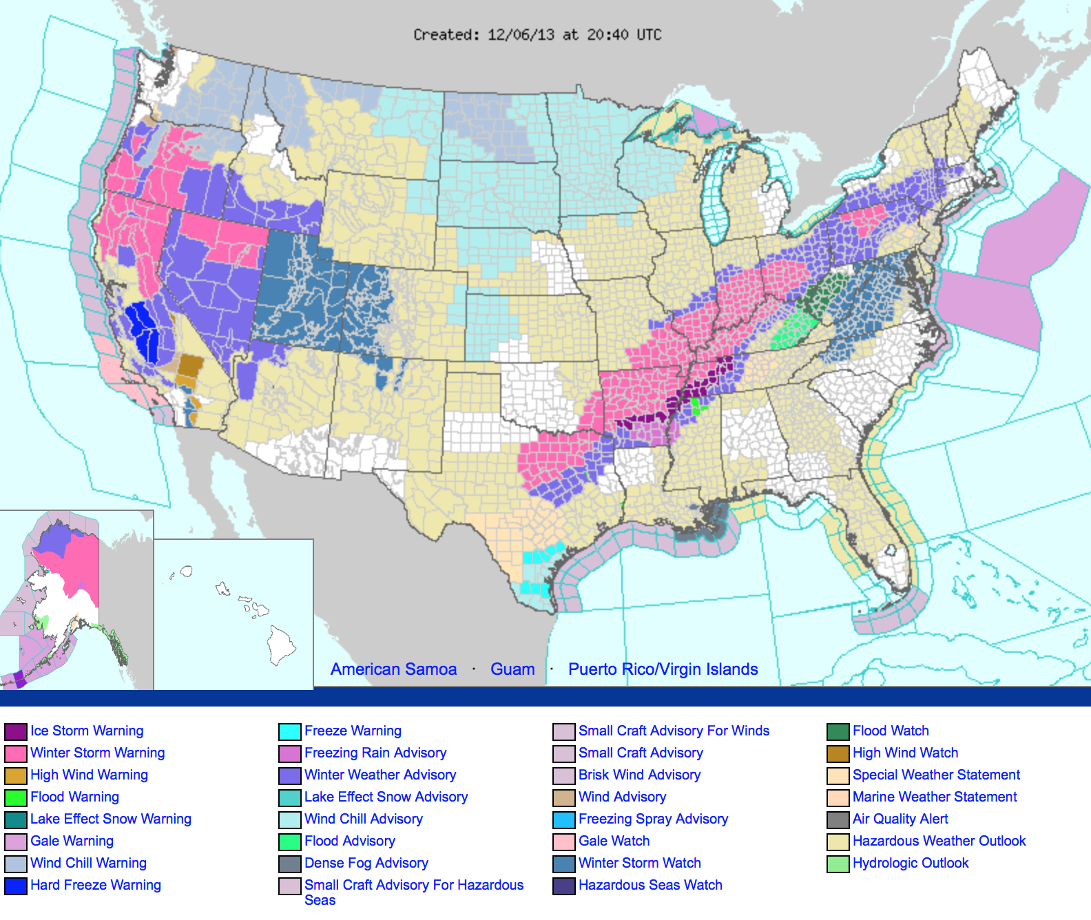
TO THE WEST: An ice storm warning remains in effect for the broad area from Memphis to just west of Nashville; Memphis has dropped to 32 degrees with some icy travel being reported. Winter storm warnings are up from Northeast Texas to Pennsylvania; if you are headed west of north, be aware of these issues tonight.
COLD SATURDAY: Tomorrow will be cloudy and cold, but probably not much rain over the northern half of the state. We won’t get out of the 40s, and some places up around Muscle Shoals will hold in the 30s all day, like today. Rain will be light and very scattered tomorrow and tomorrow night.
WET AND WARMER SUNDAY: A warm front will move northward across the state, with rain becoming widespread. The high resolution NAM shows the warm tongue reaching Birmingham by mid to late afternoon with temperatures nearing 60 degrees, but much of North Alabama will hold in the 40s as rain falls.
NEXT WEEK: The rain keeps falling Monday and Monday night, then winding down Tuesday. The 12Z GFS is slower with the end of the rain Tuesday. Rain totals between now and Tuesday of 2 to 3 inches are likely; some spots could see more. We will have to watch for flooding issues along the way. Temperatures Monday will hover around 47-50 degrees all day, and we won’t get past the mid 40s Tuesday.
There might be some risk of a few snow flurries on the back edge of the precipitation Tuesday or Tuesday night over North Alabama, but for now we don’t expect any issues if that happens.
The sun finally comes out Wednesday; the morning will be cold with a low in the 20s… we will then see a high near 50 degrees Wednesday afternoon.
The weather stays dry Thursday and Friday, but the GFS continues to look very wet for the following weekend (December 14-15). See the Weather Xtreme video for the maps, graphics, and details.
SUPER SIX FOOTBALL: A cold rain is likely in Tuscaloosa tonight with temperatures generally in the 40s.
SEC CHAMPIONSHIP: Of course, tomorrow’s title game in Atlanta which features Auburn vs Missouri will be played in the dome, but for fans headed over that way the day will be wet with light rain at times and a high around 50 degrees.
WEATHER BRAINS: Don’t forget you can listen to our weekly 90 minute netcast anytime on the web, or on iTunes. This is the show all about weather featuring many familiar voices, including our meteorologists here at ABC 33/40.
CONNECT: You can find me on all of the major social networks…
Facebook
Twitter
Google Plus
Instagram
I had a great time today visiting with the 5th graders at Glencoe Elementary School in Etowah County… be looking for them on the Pepsi KIDCAM today at 5:00 on ABC 33/40 News. My next Weather Xtreme video will be posted here by 7:00 a.m. Monday… Brian Peters will have the video updates tomorrow and Sunday. Enjoy the weekend!



