


I’ve been slaving all morning over a hot computer working on the afternoon forecast package. Here is a sneak peek:
Click image to enlarge
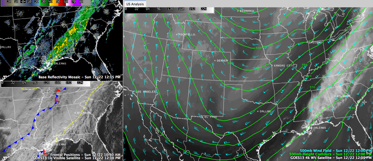
Weather maps on this Sunday afternoon are dominated by a huge upper level trough over the United States. The trough really hasn’t moved very much since the beginning of the weekend. The axis of the trough extends from Bismarck ND to El Paso, Texas. Friday night it as only a couple of hundred mile west of its current position, extending from Montana to Phoenix. It is moving slowly east now. A strong jet max (over 170 mph) is roaring across the Great Lakes. A plume of moisture extends from the Texas Coast to New England, keeping Alabama socked in with clouds.
Visible satellite imagery does indicate a few breaks in the clouds over western Alabama and eastern Mississippi. Skycams over the region confirm that. The breaks will be short lived, as more clouds will move in later.
At the surface, a prefrontal trough extends across South Central Alabama. Showers and thunderstorms cover the southeastern half of Alabama. The forward progress of the rain area has slowed as low pressure along the Gulf of Mexico near New Orleans gets ready to make a trek northeastward. This will hold things up a bit and produce heavy rainfall across South Central Alabama. A flash flood watch has been posted for this after through Monday morning for rainfall amounts that are expected to average 2-4 inches.
No more severe weather is expected today, although a couple of strong storms could affect southeastern Alabama. The main cold front is back over Arkansas, poised to sweep through our state tonight. Additional showers will form through the afternoon hours over Mississippi and Central Alabama. They will end from the northwest with the front tonight.
TRENDING TO COLDER: Colder air has filtered in behind the prefrontal trough over northwestern Alabama and the I-59 corridor. The mercury might warm back up into the middle 60s today for areas that see those breaks in the clouds work across and some warmer air is thrown back north by the low near New Orleans. But lows tonight will fall into the middle 40s as the main cold air starts arriving. This trend will continue for your Holiday week, with below average temperatures holding firm with the trough hanging out. There will even be one hard freeze thrown in for good measure.
SLOW CLEARING: The moisture will finally start to leave early tomorrow, but low clouds may hang tough for the morning hours. Highs will struggle to rise a couple of degrees from morning lows despite the increasing sunshine. You will also notice a strong northwesterly wind, averaging 10-20 mph. The winds will continue brisk into the overnight hours, which will keep Tuesday morning lows form being as cold as they could be. Most folks will be in the middle and upper 20s by then. Tuesday will feature total sunshine, but it won’t matter to the ol’ thermometer, as it will struggle to get out of the 30s!
CHRISTMAS EVE/DAY: By Christmas Eve morning, the trough axis will extend from the Great Lakes into Alabama. The coldest air will get its best shot at us by then. You can expect a hard freeze Wednesday morning, with lows in the teens in normally colder locations and widespread lower 20s. Highs on Wednesday will recover to the upper 40s and a few clouds will reappear on the scene.
REINFORCING SHOT: A dry cold front will arrive late on Thursday, reinforcing the cool air already in place across the state. After a brief flirtation with lower 50s on Thursday, we will be back in the 40s Friday afternoon thanks to the fresh batch of cool air.
RAISED EYEBROWS: The morning run of the GFS introduced an interesting idea for New Years. After getting through a chilly but dry weekend, a fast moving, moisture starved cold front may bring a chance of snow to North Alabama and light rain to southern sections that Monday night the 30th. While not a forecast at this point, it is something to keep an eye on.
VOODOO: Out in the long range model output territory, the GFS predicts another cold and moist system around the 3rd. That could mean another shot at the white stuff. A brief warm up should be sufficient to keep the system that comes in on the 6th and 7th all liquid. But stay tuned!



