


An all new edition of the ABC 33/40 Weather Xtreme video is available in the player on the right sidebar of the blog. You can subscribe to the Weather Xtreme video on iTunes by clicking here.
COLD START: Some North Alabama communities are dealing with a freeze, or at least some frost this morning. Some observations just before sunup…
Black Creek (just northeast of Gadsden) 28
Haleyville 29
Fort Payne 30
Valley Head 30
Gadsden 31
Sycamore 31
Cullman 33
Concord 33
Fayette 34
Helena 34
Anniston 36
Lake View 37
Despite the morning chill, the temperature will rise over 40 degrees in many places today; we expect a high in the mid 70s with a sunny sky. You can lose the jackets by mid-morning… it will be a beautiful early spring day.
WARMING TREND: We stay dry through Wednesday; upper 70s are likely tomorrow and Wednesday, and some places could very well touch the 80 degree mark. The sky will stay mostly sunny both days.
Moisture levels will rise Thursday, and we will mention the chance of a shower, but it looks like the most organized rain Thursday will be north and west of Alabama. The GFS is printing a high of 81 degrees for Birmingham Thursday afternoon.
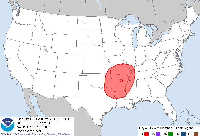
TO THE WEST: SPC has identified severe weather threats west of the state Wednesday and Thursday (the standard “slight risk”) as a significant upper trough moves out of the Rockies. The risk Thursday (Day 4) includes places like Memphis and Little Rock…
STORMS ARRIVE IN ALABAMA FRIDAY: The good news is that the primary dynamic support will pass well to the north of Alabama, and the overall risk of severe weather Friday is very low in our state. We do note that there will be plenty of surface based instability (CAPE values of 1,500 to 2,000 j/kg), but there is very little shear, and wind fields are weak. We will sure watch trends as we get closer to the end of the week, but it looks like any severe weather threat will be north of Alabama Friday where there better dynamics are in play.
THE ALABAMA WEEKEND: The GFS pushes the surface front down into South Alabama Saturday morning, with drier air over the northern counties of the state. So, for now we will forecast a dry day on Saturday with a partly sunny sky and a high in the low 70s.
Confidence in the forecast for Sunday is low due to model differences. The GFS keeps us in dry air, while the ECMWF wants to pull the moisture northward with a chance of rain. We will lean toward the drier GFS solution for now. Sunday’s high will stay in the low 70s.
LONG RANGE: The 00Z GFS really shows no severe weather look for Alabama through mid-month, which is a very good thing. But, also understand that could change since we are in the core of the spring tornado season in our state. See the Weather Xtreme video for the maps, graphics, and details.
AT THE BEACH: Mostly sunny mild days and fair nights along the coast from Panama City to Gulf Shores through Thursday (although there could be some morning fog later this week). Showers and storms return Friday into the weekend. Highs will be in the 60s along the immediate coast, with 70s just a few miles inland. The sea water temperature at the Dauphin Island Sea Lab this morning is 60 degrees.
WEATHER BRAINS: Don’t forget you can listen to our weekly 90 minute netcast anytime on the web, or on iTunes. This is the show all about weather featuring many familiar voices, including our meteorologists here at ABC 33/40. We will produce this week’s show Wednesday night (NOT tonight) at 8:30p CT.
CONNECT: You can find me on all of the major social networks…
Facebook
Twitter
Google Plus
Instagram
I will be doing a weather program this morning at Rock Quarry Elementary School in Tuscaloosa… be looking for the next Weather Xtreme video here by 4:00 this afternoon. Enjoy the day…



