



Not surprisingly, the NWS has issued a sever thunderstorm warning for those intense thunderstorms over Tallapoosa County in East Central Alabama.
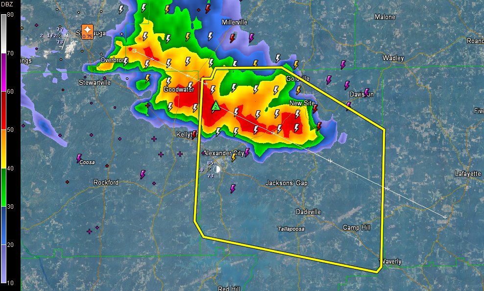
The cluster is moving southeast and sinking southward toward US-280 in the general direction of Alex City, Jackson’s Gap and Dadeville. If you are in the path of these storms, be inside until they pass. They will produce hail one inch or greater and winds of 60 mph or higher. Not to mention the deadly lightning and torrential rains.
THE NATIONAL WEATHER SERVICE IN BIRMINGHAM HAS ISSUED A
* SEVERE THUNDERSTORM WARNING FOR…
TALLAPOOSA COUNTY IN EAST CENTRAL ALABAMA…
* UNTIL 800 PM CDT
* AT 709 PM CDT…THE NATIONAL WEATHER SERVICE INDICATED A SEVERE
THUNDERSTORM CAPABLE OF PRODUCING QUARTER SIZE HAIL…AND DAMAGING
WINDS IN EXCESS OF 60 MPH. THIS STORM WAS LOCATED NEAR HILLABEE
CREEK…OR 6 MILES NORTHEAST OF ALEXANDER CITY…AND MOVING
SOUTHEAST AT 25 MPH.
* LOCATIONS IMPACTED INCLUDE…
DADEVILLE…CAMP HILL…WIND CREEK STATE PARK…NEW SITE…
JACKSONS’ GAP…JACKSONS GAP…HORSESHOE BEND AND HORSESHOE BEND
NATIONAL MILITARY PARK.
PRECAUTIONARY/PREPAREDNESS ACTIONS…
FOR YOUR PROTECTION…MOVE TO AN INTERIOR ROOM ON THE LOWEST FLOOR OF
YOUR HOME OR BUSINESS.
&&
TO REPORT SEVERE WEATHER…
CALL 1-800-856-0758 OR TWEET YOUR REPORT USING HASHTAG ALWX
LAT…LON 3272 8561 3279 8600 3282 8602 3309 8600
3309 8598 3311 8597 3311 8582 3299 8559
3273 8560
TIME…MOT…LOC 0009Z 303DEG 22KT 3299 8586
$$
73
WWWW



