


When you think of warm temperatures in December in Central Alabama, you generally think of thunderstorms and severe weather. And it is warm at the surface, with surface temperatures already in the 70s at 11 a.m. across the area.
But to get the instability necessary for thunderstorms, you have to have colder air aloft. But the air up at about 18,000 feet (or 500 millibars on a constant pressure chart) is at record warm levels.
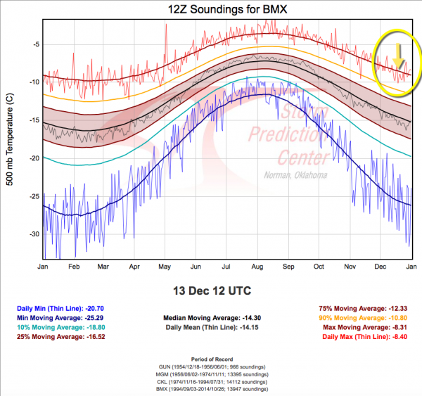
The 500 millibar temperature at BMX this morning was -7.8C, which is the warmest morning balloon sounding reading ever taken across Central Alabama on December 13th. The period of record goes back to December 1954, when soundings were taken from Gunter AFB in Montgomery.
Temperatures generally decrease with height as you go up through the atmosphere. Those warm temperatures have created an inversion, or layer where the temperatures increase as you go up with height. Air parcels that produce clouds only rise as long as they are warmer than the surrounding atmosphere. When they hit warmer air, they stop rising.
This morning, at 800 mb, or about 6,700 feet, the temperature was 9.8C. From there it started rising as you go up, peaking at 12.4C at 786 mb or 7,200 feet. This layer of warming air acts as a lid on the atmosphere. That lid is expected to be there throughout the night until the line of showers arrives after midnight as more warm air is being transported in from the south.
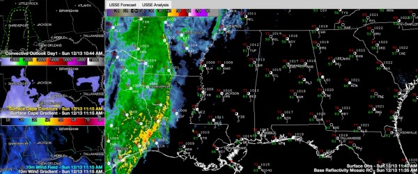
Click image to enlarge. The right panel shows the radar with warnings as well as surface observations. The top left panel shows the SPC severe weather outlook for today and tonight. The left middle panel shows current instability which is zero over Alabama. The bottom left panel shows current surface winds. Windy areas shown in blue.
There is meager instability in front of the line of storms right now over northern Louisiana, and severe thunderstorm warnings are in effect for several Louisiana parishes and southern Arkansas counties. But the warmer air aloft to the east is eliminating the instability and the line will weaken slightly.
There will be sufficient forcing along the leading edge of the system to produce a thin line of heavy showers that should reach Northwest Alabama around 10 p.m. and West Central Alabama around midnight. It will reach Tuscaloosa around 1 a.m. and Birmingham before 3 a.m., Gadsden around 4 a.m. and Anniston around 6.
The line will definitely be weakening as it approaches the Georgia border.
There could be some cloud to ground lightning at points along the line, but it will not be widespread.
There will be no severe weather with the line of showers tonight in Alabama. There is very strong wind shear, but there will be no instability.
Surface winds will be increasing ahead of the approaching system. They are averaging 15-25 mph over Mississippi right now and 10-20 mph over Alabama. They have been gusting to near 30 mph at times. They will average 15-25 with gusts to over 35 mph starting my mid-afternoon and continuing into the overnight hours. Lake wind advisories are in effect.
Holiday inflatables and other decorations will be vulnerable and should be protected. Tree branches could be blown off trees. High profile vehicles should use caution.



