It looks like we have a couple of great days ahead of us for Central Alabama that are actually coincident with the weekend. Look for dry weather today and Sunday with temperatures warming to around 60 today and into the upper 60s on Sunday as a surface centered over New Orleans this morning will slide slowly eastward through Sunday.
A weak surface front will move into the Southeast US on Monday, but the nearly zonal flow aloft from New Mexico to the Carolinas will see that front washout with only increased clouds and small chances for some showers.
Tuesday and Wednesday a fairly strong upper trough will makes its way from Oklahoma to the Carolinas. At the surface, a low pressure system will develop in the Lower Mississippi River Valley Tuesday and move rapidly northeastward to the vicinity of New York City by midday Wednesday. Tuesday, our primary election day, will be warm with some clouds but dry for most of the day until late evening and into early Wednesday. CAPE values are sufficient for some thunderstorms to occur, but the threat of severe weather appears to be relatively low in part due to a significant lack of moisture return at lower levels. GFS MOS guidance only showers dew points reaching near 50 Wednesday morning at Birmingham. But Tuesday should be warm with highs again well into the 60s with areas south of Birmingham reaching to around 70.
The front is forecast to move quickly across the Southeast US early Wednesday morning, so Wednesday could be another one of those days when the temperature readings go the wrong way. Temperatures are likely to top out early Wednesday morning in the 50s and fall slowly during the day. Rainfall is expected to be somewhat limited due to the fast passage of this system so rainfall totals are likely to top out around a half inch or so.
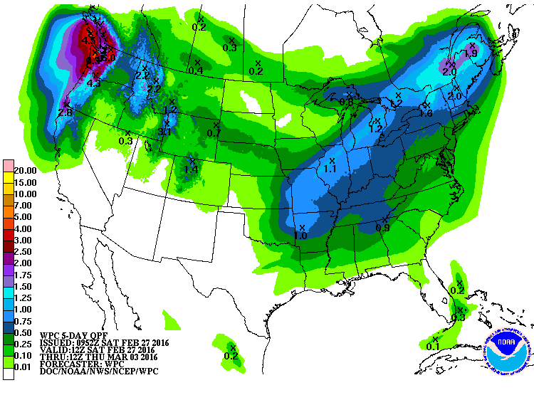
Another upper short wave trough over eastern Oklahoma on Thursday should provide another quick warmup for Alabama with highs rising back to around 60 degrees. But a surface low over the ARKLATEX will push eastward across the Southeast US to a point just east of Jacksonville by midday Friday. This will provide us with yet another chance for showers late Thursday into the first half of Friday with highs around 60. But with that system moving quickly by we should see the weather improve during the latter half of Friday paving the way for another nice weekend with highs in the lower 60s and lows around 40.
The overall flow for the week ahead is going to be rather fast, and that trend continues into voodoo country. A substantial ridge on March 7 and 8 promises a nice warmup as a deep trough develops over the western states extending all the way south into Baja California. That system will be slow to come eastward holding off until around the 11th of March. But keep your seat belts fastened for another strong trough is forecast to come into the Lower Mississippi River Valley by the 13th of March promising another potential round of thunderstorms.
I had a great time visiting with the folks at Black Warrior Methane in Brookwood yesterday morning. I especially appreciated their invitation to stay and join them for lunch and a fabulous crawfish boil! I plan to have the next edition of the Weather Xtreme Video posted here by 8 am or so on Sunday morning. Make plans to enjoy the weekend and the great weather. Godspeed.
-Brian-