


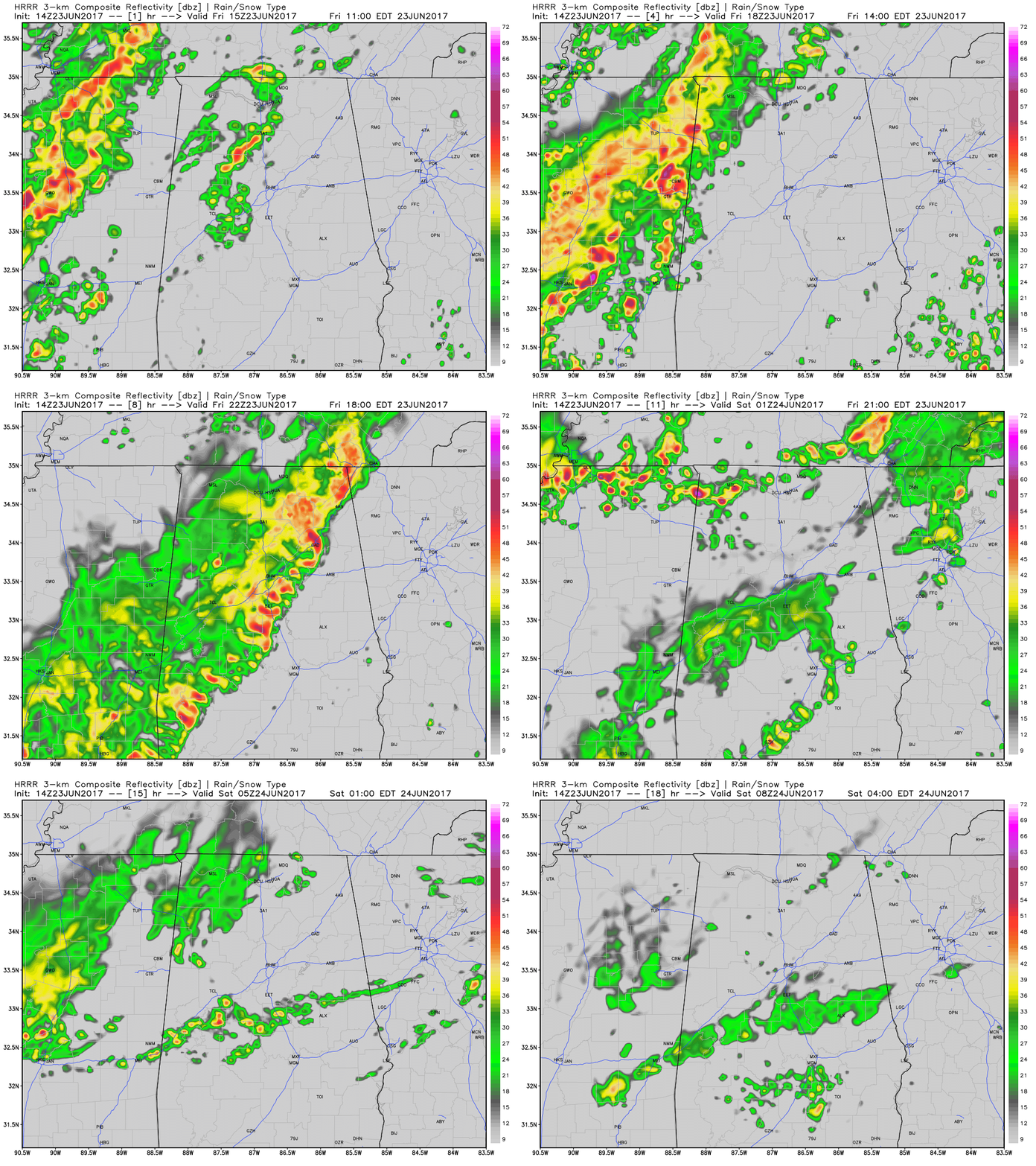
We will deal with more severe weather this afternoon and this evening across North and Central Alabama as Tropical Depression Cindy (yes, still a tropical depression) turns eastward across Tennessee.
ROUND ONE
A double line of broken rain and storms is pushing eastward across Mississippi this morning. There are already tornado warnings in Northeast Mississippi. This activity will be pushing into West Alabama’s Marion and Franklin by 11:15 a.m. It should arrive in Lamar County before noon and into Sumter/Pickens County by 1:30 p.m. Projected time in Tuscaloosa/Jasper will be 2 -3 PM and Birmingham 3-4 p.m.
MOISTURE/INSTABILITY
We still are in a very moist atmosphere across the state, with precipitable water values ranging from to 1-5-2 inches in the east and 2-2.4 in the west, with a max near the state line over Lamar and Pickens County. The airmass is moderately unstable, with CAPE values currently running about 1000-1500 joules over Central Alabama. CAPEs will increase to around 2000-2500 later this afternoon.
SHEAR
There is plenty of shear across Alabama thanks to the wind field around Cindy. There is 25-40 knots of bulk shear northwest of I-59, which is plenty sufficient for organized storms. There is 250-300 m2/s2 of 0-1 km helicity over Northwest Alabama. This is all indicative of tornado potential. The Significant Tornado Parameter is running about 1 over the northern half of the state. That is sufficient for a few isolated significant tornadoes like yesterday.
JET STRUCTURES
The strong wind fields go up into the atmosphere. A broad trough dominates the country and it will be digging southward over the weekend, sweeping Cindy out quickly and moving a refreshing cold front through the area tomorrow, setting the stage for a nice five day run of weather with low humidities and dry conditions. Look for a small jet feature to develop over the Tennessee Valley this afternoon, which might enhance the storms. At 500 mb (18,000 feet) there are strong winds over Alabama (45-55 knots), and they stay strong through this evening. A strong 850 mb jet develops over Alabama this evening, peaking at between 50-60 knots. Any updrafts that tap these strong winds will be able to easily produce damaging winds.
SURFACE LOW
The low that is Cindy will be north of Memphis by noon and near Nashville by 7 p.m. By midnight it will be over eastern Kentucky.
FRONT
The cold front should reach I-20 by 7 a.m. tomorrow morning and the push into Northwest Florida by 7 a.m. Sunday.
ROUND TWO
Another round of storms will impact West Alabama it appears this evening between 8 p.m. and 11 p.m. These storms could be severe west of I-65, but should weaken after that.
ROUND THREE
It looks like another round of storms will affect South Central Alabama Saturday morning.
ROUND FOUR?
The WRF shows a third round of storms across Northwest Alabama by noon tomorrow and into Birmingham by 3-4 p.m. I am a little skeptical of that, but we will see. The SPC does not have any of Alabama in a severe weather risk tomorrow.
RISK LEVELS THROUGHOUT TODAY AND TONIGHT
SPC continues to have much of the northern half of the state defined in a Slight Risk (level 2 out of 5) for the rest of the day and through the overnight areas. The main risk will once again be from brief isolated spin-up tornadoes, but damaging wind gusts will be possible as well.
FLASH FLOOD WATCH
A Flash Flood Watch continues in effect for much of Central Alabama until 7PM tonight. Rainfall totals of 2 to 4 inches and localized amounts being higher, conditions will persist today as an additional 1 to 3 inches will be possible from the tropical moisture of the remnants of Cindy. The watch could be extended into Saturday with the approach of a frontal boundary and more expected rainfall.



