


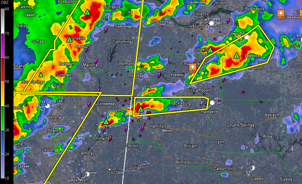
Storms are strengthening over Northwest Alabama and Northeast Mississippi ahead of the main line of storms with is about 40 miles behind the initial activity.
Storms over Itawamba County MS and Marion County Alabama are intensifying but not severe yet. LIghtning is increasing as is heavy rain. Hail is likely approaching one inch now along I-22 on the Alabama/Mississippi border northwest of Hamilton. Warnings could be coming shortly.
LATE NOTE
The NW Birmingham just issued a severe thunderstorm warning for Marion County.
Just to the north, severe storms are over Franklin, Lauderdale and Colbert Counties as well as Limestone and Madison Counties. Marble sized hail was reported in Russellville and dime sized hail in Athens.
The SPC just issued a discussion and puts the chance at 80% that they will issued a watch shortly for much of Central Alabama east and southeast of the current watch.
There are strong indications that we will deal with hail up to 2 inches in diameter this afternoon generally in areas south of I-20. The atmospheric conditions are right for large hail, with the wet blub zero height around 8-9,000 feet. This is right in the middle of the sweet spot for large hail.
CAPE values will be going up as the temperature rises into the 70s, approaching 1,000-1,500 joules. This is all we need for severe weather in Central Alabama this time of year.
The good news is that low level wind shear values will diminish quickly this afternoon, with 0-1 km storm relative helicity dropping from 220 m2/s2 around noon to less than 100 m2/s2 by mid afternoon. These values need to be between 250-350 for a significant tornado threat this time of year.
The lifted condensation level will also be rising, which is a good sign, as temperatures increase and the spread between the temperature and dewpoint rises. Those values will rise from around 700m, where they have been all morning to more like 2,000m by midafternoon. This makes it harder for tornadoes to form. LCLs need to be around 550-600m for tornadoes in Central Alabama.
So the tornado threat is small. Can’t rule out the possibility of one with stronger storms, but the threat is small.
There is an isolated threat of damaging winds though over Central Alabama, with a higher threat over the Tennessee Valley.
We will be actively monitoring the situation and reporting throughout the afternoon and evening here on the blog.



