


CONGRATS TO THE BIRMINGHAM STALLIONS ON WINNING THE INAUGURAL UFL CHAMPIONSHIP AND THEIR THIRD CHAMPIONSHIP IN A ROW. THE HEADLINES ARE IN STALLION RED TO CELEBRATE THEIR INCREDIBLE SEASON.
Spann is out on vacation this week, so Bill Murray and I will be bringing you this week’s morning briefing videos. We will be on a one-video-per-day schedule through Friday. Spann returns on Monday.
THIS WEEK’S OUTLOOK
Ridging will expand over the Mid-Atlantic states today and by the afternoon, drier air will move westward from Georgia and the Carolinas. While everyone will have a chance of rain, the eastern half of Central Alabama will only see a few isolated showers and storms, while the western half will see scattered to numerous showers and storms. Highs in the lower to mid 90s.
While the weather will be calm on Tuesday, our attention will be focused on the southwestern Gulf of Mexico as we may see a depression form and bring tropical rainfall to the western and northwestern Gulf Coast. For us, we’ll be dry with partly sunny skies, and highs in the upper 80s to the lower 90s.
Ridging will continue to hold strong over the southeast and will keep our weather calm for Juneteenth. Highs will be in the upper 80s to the lower 90s under partly sunny skies.
On Thursday, we’ll continue the stretch of dry weather with a decent bit of sunshine. However, the ridge over the southeast will allow for a tropical wave to move toward the southeastern US, and potentially making landfall on Thursday evening or into the pre-dawn hours on Friday. More on that in the tropical update. Highs in the upper 80s to the mid 90s, but those may be lowered by a few degrees if the recent model trends continue.
With tropical moisture starting to flow westward on Friday from the land falling wave, scattered showers and storms look to be possible over the southern third of Central Alabama, while we may see an isolated shower somewhere over the northern 2/3rds. Highs in the lower to mid 90s, but as stated for Thursday’s forecast, these highs may be backed down by a couple of degrees in later forecasts.
THIS WEEKEND’S OUTLOOK
With that deep tropical moister in place throughout the upcoming weekend, scattered showers and storms will be possible over the southern half of the area on both days, and a few isolated showers can’t be ruled out over the northern half. Saturday’s highs will be in the lower to mid 90s, with will almost exactly match the forecasted highs on Sunday.
TROPICAL OUTLOOK
9 pm Sunday Night
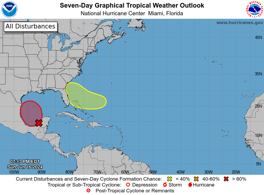
A large area of disturbed weather is currently over Central America, the Yucatán Peninsula of Mexico, and the nearby waters of the northwestern Caribbean Sea and southern Gulf of Mexico. Within the next day or so, this system is expected to develop into a broad area of low pressure over the southwestern Gulf of Mexico. Conditions are favorable for gradual development, and a tropical depression or tropical storm is likely to form by midweek. This system will move slowly towards the western Gulf coast.
Whether or not this system develops, expect several days of heavy rainfall across parts of southern Mexico and Central America, which could lead to life-threatening flooding and flash floods. Heavy rainfall is also expected to reach the northwestern coast of the Gulf of Mexico by midweek. Gale warnings have been issued for parts of the Gulf of Mexico already. Formation chance within the next 48 hours is at 50%, and there’s a 70% chance of formation within the next 7 days.
Meanwhile, in the southwestern Atlantic Ocean, an area of low pressure is forecast to form a few hundred miles northeast of the central Bahamas in the next couple of days. While environmental conditions could support some development as it moves westward or west-northwestward, the system is expected to approach the southeast U.S. coast by Thursday or Friday. Formation chance within the next 48 hours is near 0%, but it increases to 30% over the next 7 days.
ON THIS DAY IN WEATHER HISTORY: 2010
One of the most severe weather events to occur on June 17th in history was the tornado outbreak on June 17, 2010. This event primarily affected the Upper Midwest of the United States, particularly Minnesota, which experienced a state record of 48 tornadoes in a single day. Among the 74 tornadoes recorded across four states, 15 were classified as EF2 or stronger, including four EF4 tornadoes. These tornadoes caused significant damage, including widespread destruction of homes and businesses, and resulted in three fatalities and many injuries.
CELEBRATING NATIONAL DAYS
So, we have a list of events, festivals, weird, funny, and national days set for this day of the year. Here’s what we can celebrate:
– National Eat Your Vegetables Day
– World Tessellation Day
– World Day to Combat Desertification and Drought
– National Take Your Cat to Work Day
– National Stewart’s Root Beer Day
– Global Garbage Man Day
– National Apple Strudel Day (don’t tell Nathan Detroit!)
SEVERE WEATHER SAFETY
Weather can be unpredictable, catching us off guard with its sudden changes. From thunderstorms to tornadoes or flash floods, being ready beforehand can be a lifesaver. Alabama, with its varied climate, faces its share of severe weather. That’s why having a solid safety plan is so important for everyone. Check out our Severe Weather Safety Guide for valuable tips on how to stay safe when severe weather is on the horizon.
BEACH FORECAST CENTER
Please visit our Beach Forecast Center page to access the most up-to-date weather and rip current forecasts for the beaches spanning from Fort Morgan to Panama City. On this platform, you can choose the forecast specific to the region you intend to visit, ensuring you have accurate and relevant information for your plans.
ADVERTISE ON THE BLOG
Ensure you don’t miss this opportunity! Allow us to tailor a bespoke package designed to meet the unique requirements of your organization. Our offerings are creative, flexible, and affordably priced. For further details and inquiries, please reach out to Bill Murray at (205) 687-0782.
E-FORECAST SIGN UP
Receive the Alabama Weather Blog’s comprehensive Seven-Day Forecast directly to your inbox via email, delivered twice daily. Recognized as the most detailed weather forecast accessible in Central Alabama, our service ensures you stay informed and prepared. Subscribe now to access this valuable resource at no cost!



