


EARLY THIS MORNING: We have a weakening band of showers and storms pushing through North and West Alabama, and a few isolated storms over the central counties of the state. The airmass remain very humid with high precipitable water values; dewpoints are in the 70s.
The morning activity will continue to weaken in coming hours and slowly dissipate. With some midday sun, the air heats up quickly and becomes unstable this afternoon, meaning additional thunderstorm formation. With colder air aloft, some dynamic forcing coming into play, and a boundary left over from the morning convection, the storms later today could be strong to severe. SPC has an enhanced risk (level 3 out of 5) now defined for much of North Alabama…
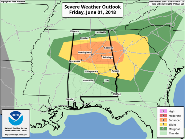
Where storms form this afternoon, they could produce large hail and damaging straight line winds. Most of these heavier storms will come from 10:00 a.m. until 10:00 p.m… they will be in random places. If you have an outdoor event planned, just keep a close eye on radar and pay attention to severe thunderstorm warnings if they are required. The high today will be in the upper 80s in most places.
THE ALABAMA WEEKEND: SPC has a marginal risk (level 1 out of 5) defined for much of the state tomorrow. While a decent part of the day will dry, a few scattered storms will form tomorrow afternoon with potential for some hail and strong gusty winds. The chance of any one spot seeing a storm tomorrow is about one in four, otherwise the day will be partly sunny, hot, and humid with a high around 90 degrees.

High resolution model data suggests a weakening band of storms could push into Alabama during the pre-dawn hours Sunday ahead of a cold front. Then, during the day, the higher probabilities of storms will push into East and South Alabama ahead of the front. SPC has a marginal risk defined there.

A decent part of North Alabama should be dry during the day Sunday with that better chance of storms to the east and south. The sky will be partly sunny with a high between 87 and 90 degrees.
DRIER AIR NEXT WEEK: Dry, continental air rolls into Alabama Sunday night, and most of next week looks rain-free for a change with lower humidity levels and cooler nights. Expect lots of sunshine each day with highs in the 80s; early morning lows will be well down in the 60s. Cooler spots will visit the 50s Monday, Tuesday, and Wednesday morning. Moisture levels slowly rise late in the week, and a few scattered showers could break out Friday (one week from today), but nothing really widespread. See the Weather Xtreme video for maps, graphics, and more details.

HURRICANE SEASON BEGINS TODAY: Today marks the first day of the Atlantic hurricane season, which will run until November 30. Long-term averages for the number of named storms, hurricanes, and major hurricanes are 12, 6, and 3, respectively.
Here are the 2018 names: Alberto, Beryl, Chris, Debby, Ernesto, Florence, Gordon, Helene, Isaac, Joyce, Kirk, Leslie, Michael, Nadine, Oscar, Patty, Rafael, Sara, Tony, Valerie, and William.
The tropics are quiet now, and tropical storm formation is not expected through next week.
BEACH FORECAST: Click here to see the AlabamaWx Beach Forecast Center page.
WEATHER BRAINS: Don’t forget you can listen to our weekly 90 minute netcast anytime on the web, or on iTunes. This is the show all about weather featuring many familiar voices, including our meteorologists here at ABC 33/40.
CONNECT: You can find me on all of the major social networks…
Facebook
Twitter
Google Plus
Instagram
Pinterest
Snapchat: spannwx
Look for the next Weather Xtreme video here by 4:00 this afternoon… enjoy the day!



