


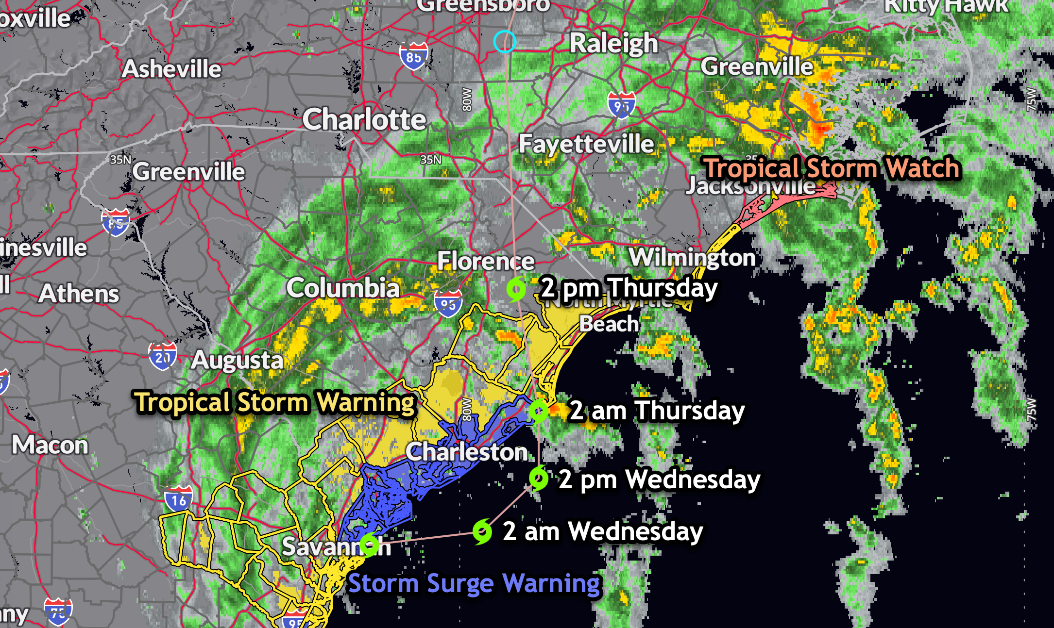
Surface, satellite, and radar data indicate that Tropical Storm Debby continues to linger near the coastline around the Georgia/South Carolina border. The storm currently lacks strong convection near its center, with the tropical-storm-force winds occurring mainly in bands to the northeast and east of the center, as confirmed by an earlier ASCAT pass. The central pressure remains unchanged, and the intensity is maintained at 35 knots (40 mph).
Current Motion and Forecast Track:
Debby is trapped in a zone of weak steering currents within the subtropical ridge, resulting in a slow eastward drift at approximately 3 knots. The track guidance indicates that Debby will generally move eastward for the next 24 hours, temporarily moving offshore. By 24-36 hours, a building mid-level ridge should turn Debby northward, with landfall expected early Thursday. The system will then accelerate northeastward over the eastern and northeastern U.S. ahead of an approaching mid-level trough. The forecast track has been adjusted slightly left and faster based on the latest consensus model guidance.
Intensity Forecast:
As Debby moves back over water tonight and Wednesday, some re-strengthening is anticipated. However, due to the lack of an inner core and limited interaction with the high oceanic heat content of the Gulf Stream, significant intensification is unlikely. The official intensity forecast is at the high end of the model guidance.
Key Messages:
1. Heavy Rainfall and Flooding: Potentially historic heavy rainfall across eastern South Carolina through Friday may result in catastrophic flooding. Significant flooding impacts are expected from central to the Upstate of South Carolina, western North Carolina, and Southwest Virginia through portions of the Mid-Atlantic States, western and northern New York State, and northern New England through Saturday.
2. Tropical Storm Conditions: Tropical storm conditions will spread northward along the southeast U.S. coast from northeastern Georgia to North Carolina through Thursday. Tropical storm warnings and watches are in effect for portions of this area.
3. Storm Surge: A dangerous storm surge is possible along the coast of South Carolina and southeastern North Carolina from South Santee River to Cape Fear. Residents in the area should follow any advice given by local officials.



