


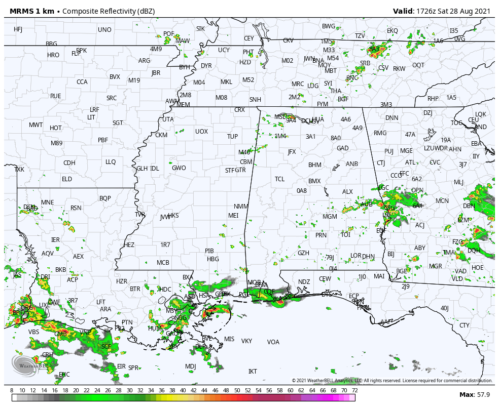
For the most part, Central Alabama is dry and very warm, as we have reached the halfway point of the midday hour. We do have some shower and thunderstorm activity over the southeastern parts of the area, and a few spotty showers over the northwestern parts. Temperatures were in the lower 80s to the lower 90s across the area. Troy was at 90 degrees. Auburn was at 82 degrees with rain-cooled air and clouds. Birmingham was sitting at 86 degrees.
We’ll continue to have partly to mostly cloudy skies throughout the remainder of the daylight hours, with a chance of isolated to scattered showers and thunderstorms. Coverage will be more limited in the northern half of the area, while more numerous in the southern half. Afternoon highs will get up into the upper 80s to the lower 90s. For tonight and through the overnight hours, any shower activity will subside by the end of the evening, and we’ll be partly cloudy throughout the rest of the nighttime hours. Lows will be in the lower to mid 70s.
It will be nearly the same story through a decent part of your Sunday, but as Hurricane Ida moves onshore in Louisiana, we’ll start to see the outer rain bands move into the southern and southwestern parts of the area. The best chance of rain will occur along and south of a line from Tuscaloosa to Clanton to Troy. Coverage will be more scattered and widespread in nature north of that. Highs will be in the upper 80s to the lower 90s.
CENTRAL ALABAMA IMPACTS FROM HURRICANE IDA: With tropical systems that move through the Southeast, the eastern side of the storms are usually the more active side with heavy rainfall and the potential for a few tropical-type, brief spin-up tornadoes, and Central Alabama will be on that eastern side on Monday and Tuesday. Here is a brief synopsis of what we can expect:
• The potential for rainfall amounts ranging from as little as 1/2-inch in the extreme eastern and southeastern parts of the area, to as much as 4-6 inches over the extreme western parts of the area, with localized heavier amounts through Wednesday evening. Flooding issues will be possible for locations west of I-65.
• It will be quite breezy at times, with potential wind gusts reaching or exceeding 40 mph, especially over the west and northwestern parts of the area and any higher elevations.
• A few tornadoes will be possible on Monday and Tuesday across all of Central Alabama. A Marginal Risk is up for locations along and south of a line from roughly Tuscaloosa to Montgomery to Troy for Sunday night through sunrise on Monday, then the risk expands to include everyone along and west of a line from roughly Hamilton to Clanton, to Fort Deposit throughout the rest of Monday and through sunrise on Tuesday.
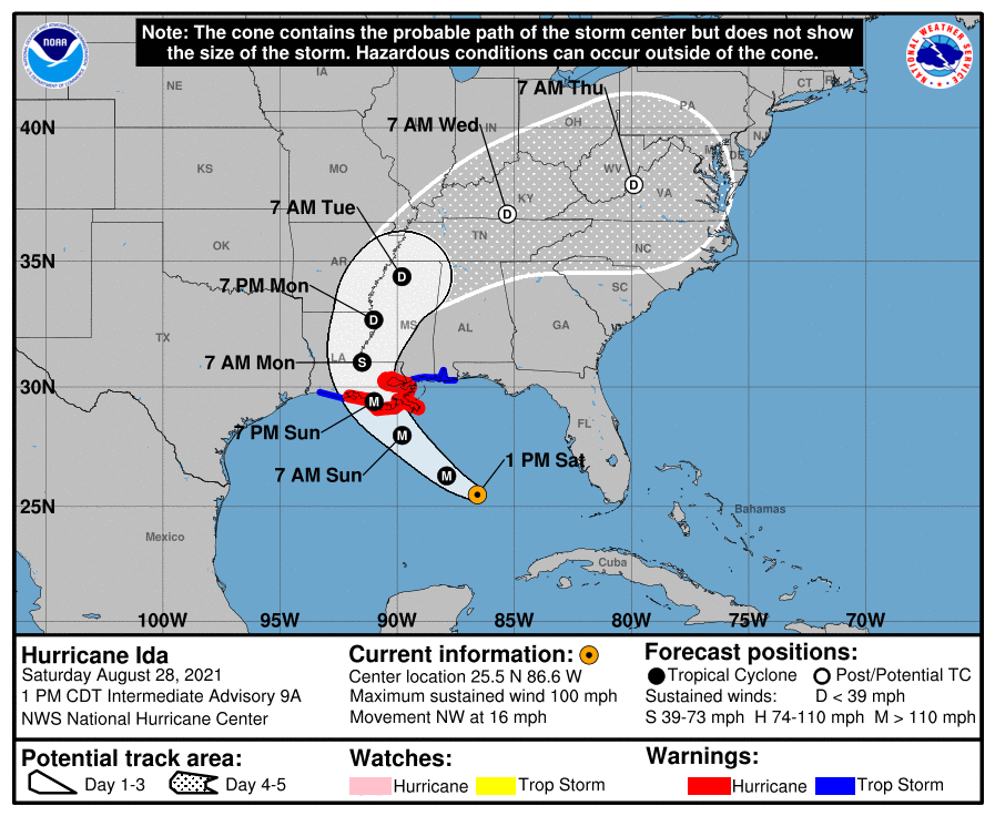
UPDATE ON HURRICANE IDA: The 1 pm advisory is out as Ida has now strengthened with 100 mph maximum sustained winds and a minimum central pressure of 976 mb. The eye was located around 290 miles south-southeast of the mouth of the Mississippi River and was moving to the northwest at 16 mph. Click HERE to see the 1 pm advisory.
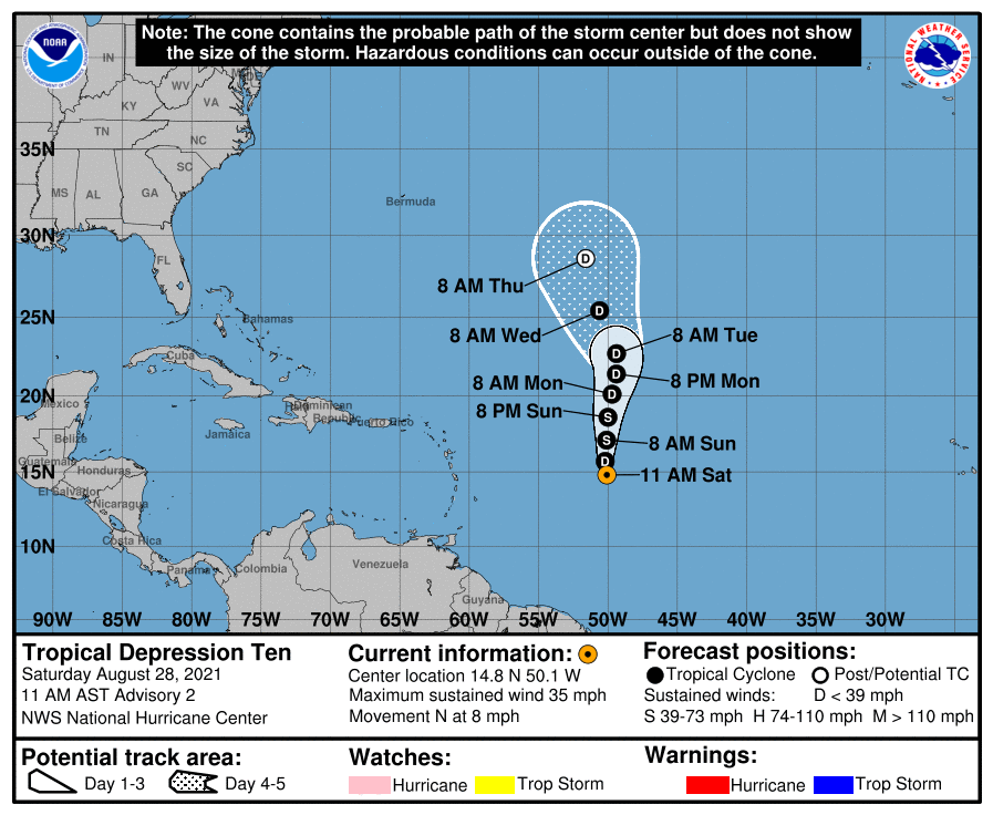
TROPICAL DEPRESSION 10: TD-10 formed earlier this morning and is struggling through a good bit of wind shear and a rather dry environment. NHC still believes it will strengthen enough to become a weak tropical storm and gain the name of Julian as it moves mainly in a northerly direction, before eventually weakening back to a depression and becoming a remnant low by Thursday morning at the latest. 10 will be no threat to land.
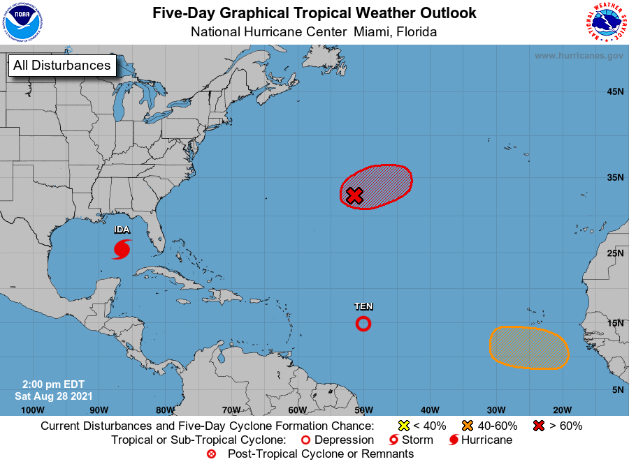
TWO OTHER PLACES OF INTEREST OUT IN THE TROPICS: Showers and thunderstorms continue to show signs of organization in association with an area of low pressure located over the central Atlantic. In addition, satellite wind data indicate that the circulation has become a little better defined. Although environmental conditions remain only marginally conducive for further development, only a slight increase in organization would result in the formation of a tropical depression later today or tonight. In a couple of days, the system is forecast to be absorbed by a frontal system. The disturbance is expected to drift eastward through today, then accelerate northeastward Sunday toward the central North Atlantic. No threat to the US.
A tropical wave is expected to emerge off the coast of West Africa by the middle of next week. Thereafter, environmental conditions appear somewhat conducive for gradual development toward the end of next week as the system moves west-northwestward to northwestward at 10 to 15 mph. Tropical cyclone formation chance through the next five days…medium…60 percent.



